National Register of Historic Places listings in Marin County, California
This list includes properties and districts listed on the National Register of Historic Places in Marin County, California. Click the "Map of all coordinates" link to the right to view a Google map of all properties and districts with latitude and longitude coordinates in the table below.[1]
-
- This National Park Service list is complete through NPS recent listings posted May 1, 2015.[2]
| [3] | Name on the Register[4] | Image | Date listed[5] | Location | City or town | Description |
|---|---|---|---|---|---|---|
| 1 | Alexander-Acacia Bridge | 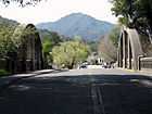 |
(#84000903) |
Alexander Avenue between Acacia and Monte Vista Avenues 37°55′48″N 122°31′55″W / 37.929978°N 122.532033°W |
Larkspur | |
| 2 | Angel Island, U.S. Immigration Station | 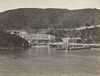 |
(#71000164) |
Southeast of Tiburon in San Francisco Bay 37°51′44″N 122°25′53″W / 37.862222°N 122.431389°W |
Tiburon | |
| 3 | William G. Barrett House | 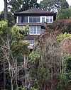 |
(#80004490) |
156 Bulkley Avenue 37°51′25″N 122°28′52″W / 37.856936°N 122.481225°W |
Sausalito | |
| 4 | Boyd House | 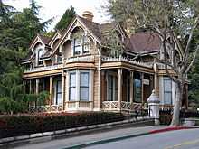 |
(#74000528) |
1125 B Street 37°58′31″N 122°31′46″W / 37.975281°N 122.529369°W |
San Rafael | Now houses the Marin History Museum |
| 5 | Bradford House | 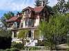 |
(#80000818) |
333 G Street 37°58′37″N 122°32′13″W / 37.976931°N 122.536817°W |
San Rafael | |
| 6 | China Camp | 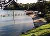 |
(#79000493) |
247 North San Pedro Drive 38°00′03″N 122°27′41″W / 38.000844°N 122.461339°W |
San Rafael | |
| 7 | The Dipsea Trail | 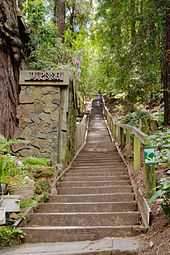 |
(#10000356) |
Throckmorton Avenue, Sequoia Valley Road, Panoramic Highway, State Route 1, Muir Woods National Monument, Golden Gate National Recreation Area Coordinates missing |
Mill Valley and Stinson Beach vicinity | |
| 8 | Dixie Schoolhouse | 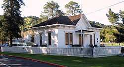 |
(#72000236) |
2255 Las Gallinas Avenue 38°01′46″N 122°32′46″W / 38.029347°N 122.546192°W |
San Rafael | |
| 9 | Robert Dollar Estate | 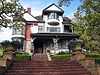 |
(#72000237) |
1408 Mission Avenue 37°58′33″N 122°31′56″W / 37.975822°N 122.532108°W |
San Rafael | |
| 10 | Robert Dollar House | 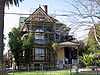 |
(#91000920) |
115 J Street 37°58′48″N 122°32′28″W / 37.979872°N 122.541122°W |
San Rafael | |
| 11 | Dolliver House | 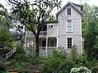 |
(#78000703) |
58 Madrone Avenue 37°55′53″N 122°32′15″W / 37.931386°N 122.537525°W |
Larkspur | |
| 12 | Drakes Bay Historic and Archeological District |  |
(#12001006) |
Address Restricted 38°02′03″N 122°56′27″W / 38.034223°N 122.940800°W |
Point Reyes Station vicinity | The recognized landing site of Francis Drake in 1579 and Sebastian Rodriguez Cermeño in 1595, and the early interactions between Native Americans and these European visitors. |
| 13 | Fashion Shop and Stephen Porcella House | 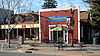 |
(#80000817) |
800 Grant Avenue and 1009 Reichert Avenue 38°06′26″N 122°33′59″W / 38.107253°N 122.5665°W |
Novato | |
| 14 | Forts Baker, Barry, and Cronkhite | |
(#73000255) |
South of Sausalito off U.S. Route 101 37°50′09″N 122°28′40″W / 37.835833°N 122.477778°W |
Sausalito | Forts Baker, Barry and Cronkhite form a historical district together. |
| 15 | Green Brae Brick Yard | 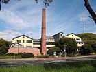 |
(#78000704) |
125 East Sir Francis Drake Boulevard 37°56′41″N 122°30′20″W / 37.944822°N 122.505517°W |
Larkspur | Now known as The Melting Pot restaurant |
| 16 | Griswold House | 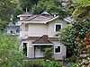 |
(#85002306) |
639 Main Street 37°50′56″N 122°29′07″W / 37.848764°N 122.485172°W |
Sausalito | |
| 17 | Hamilton Army Air Field Discontiguous Historic District | |
(#98001347) |
Mostly the southwest part of Hamilton Army Air Field 38°03′33″N 122°30′52″W / 38.059147°N 122.514444°W |
Novato | |
| 18 | Larkspur Downtown Historic District | 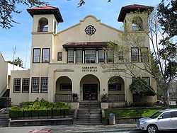 |
(#82000972) |
234-552½ Magnolia Avenue 37°56′06″N 122°32′08″W / 37.935136°N 122.535461°W |
Larkspur | |
| 19 | Lyford's Stone Tower | 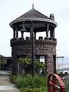 |
(#76000497) |
2034 Paradise Drive 37°52′24″N 122°26′57″W / 37.873392°N 122.449253°W |
Tiburon | |
| 20 | Benjamin and Hilarita Lyford House | .JPG) |
(#00001268) |
376 Greenwood Beach Road 37°53′40″N 122°29′50″W / 37.894464°N 122.497297°W |
Tiburon | |
| 21 | Marin County Civic Center | 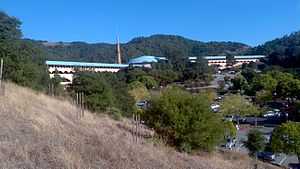 |
(#91002055) |
Junction of North San Pedro Road and Civic Center Drive 37°59′51″N 122°31′49″W / 37.997514°N 122.530353°W |
San Rafael | The last commission of architect Frank Lloyd Wright[6] |
| 22 | Erskine B. McNear House | 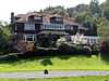 |
(#82002204) |
121 Knight Drive 37°59′06″N 122°28′46″W / 37.985131°N 122.479419°W |
San Rafael | |
| 23 | Miller Creek School Indian Mound | Upload image | (#71000163) |
Address restricted |
San Rafael | |
| 24 | Mount Tamalpais Mountain Theater | 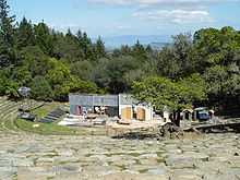 |
(#14001234) |
3801 Panoramic Hwy. 37°54′47″N 122°36′30″W / 37.913°N 122.6084°W |
Mill Valley vicinity | |
| 25 | Muir Beach Archeological Site | Upload image | (#81000097) |
Address restricted |
Marin City | |
| 26 | Muir Woods National Monument | 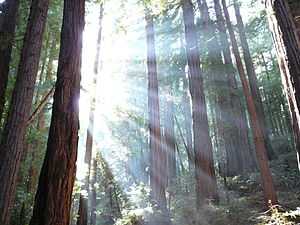 |
(#07001396) |
Muir Woods Road 37°53′33″N 122°34′20″W / 37.892547°N 122.572286°W |
Mill Valley | |
| 27 | Olema Lime Kilns | .jpg) |
(#76000217) |
4 mi (6.4 km) southeast of Olema on State Route 1 37°59′18″N 122°44′46″W / 37.988333°N 122.746111°W |
Olema | |
| 28 | Outdoor Art Club | 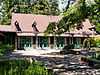 |
(#78000705) |
1 W. Blithedale Avenue 37°54′25″N 122°32′49″W / 37.906897°N 122.546883°W |
Mill Valley | 1904 American Craftsman style clubhouse designed by Bernard Maybeck. 1923 wing by William Huson. With mature gardens and pergola.[7] |
| 29 | Pierce Point Ranch | 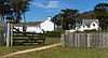 |
(#85003324) |
Point Reyes National Seashore 38°11′23″N 122°57′15″W / 38.1896°N 122.954244°W |
Inverness | |
| 30 | Point Bonita Light Station | .JPG) |
(#91001099) |
Point Bonita 37°48′56″N 122°31′46″W / 37.815608°N 122.529542°W |
Sausalito | Built in 1887 in the Marin Headlands at entrance to San Francisco Bay. Last manned lighthouse on the California coast (until 1980). |
| 31 | Point Reyes Lifeboat Rescue Station, 1927 | 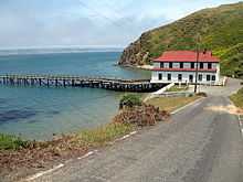 |
(#85002756) |
Drake's Bay, Point Reyes National Seashore 37°59′39″N 122°58′25″W / 37.994122°N 122.973747°W |
Inverness | |
| 32 | Point Reyes Light Station | 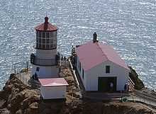 |
(#91001100) |
Point Reyes National Seashore 37°59′44″N 123°01′24″W / 37.995511°N 123.023217°W |
Point Reyes | Completed and first lit in 1870. Automated in 1975. |
| 33 | Rancho Olompali |  |
(#73000409) |
Olompali State Historic Park 38°09′12″N 122°34′18″W / 38.153333°N 122.571667°W |
Novato | Site of Coast Miwok village, Mexican Rancho Olompali and subsequent ranch buildings. |
| 34 | Valentine Rey House | .JPG) |
(#82002203) |
428 Golden Gate Avenue 37°51′54″N 122°27′37″W / 37.865067°N 122.460306°W |
Belvedere | |
| 35 | San Francisco and North Pacific Railroad Station House-Depot | .JPG) |
(#95000997) |
1920 Paradise Drive 37°52′21″N 122°27′08″W / 37.872589°N 122.452186°W |
Tiburon | |
| 36 | San Rafael Improvement Club |  |
(#84000907) |
1800 5th Avenue 37°58′30″N 122°32′20″W / 37.975094°N 122.538756°W |
San Rafael | |
| 37 | Sausalito Woman's Club |  |
(#93000272) |
120 Central Avenue 37°51′07″N 122°28′51″W / 37.851886°N 122.48095°W |
Sausalito | 1918 building by Bay Area architect Julia Morgan[8] |
| 38 | Brock Schreiber Boathouse and Beach | 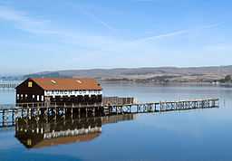 |
(#78000702) |
12830 Sir Francis Drake Boulevard 38°06′01″N 122°51′16″W / 38.100314°N 122.854436°W |
Inverness | |
| 39 | Station KPH Operating Station | 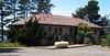 |
(#89000819) |
18500 State Route 1 38°08′39″N 122°52′38″W / 38.144167°N 122.877222°W |
Marshall | |
| 40 | Station KPH, Marconi Wireless Telegraph Company of America | 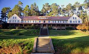 |
(#88003223) |
18500 State Route 1 38°08′39″N 122°52′38″W / 38.144167°N 122.877222°W |
Marshall | |
| 41 | Steamship Tennessee remains | Upload image | (#81000102) |
Address restricted |
Marin City | |
| 42 | Tomales Presbyterian Church and Cemetery | 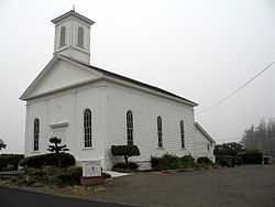 |
(#75000437) |
11 Church Street 38°14′43″N 122°54′26″W / 38.245325°N 122.907111°W |
Tomales | |
| 43 | West Point Inn | 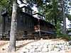 |
(#11000934) |
Old railroad grade, Mt. Tamalpais 37°55′00″N 122°35′38″W / 37.916686°N 122.593903°W |
Mill Valley vicinity | 1904 inn at the westernmost point of the Mount Tamalpais and Muir Woods Railway[9] |
See also
| Wikimedia Commons has media related to National Register of Historic Places in Marin County, California. |
- National Register of Historic Places listings in California
- List of National Historic Landmarks in California
- California Historical Landmarks in Marin County, California
References
- ↑ The latitude and longitude information provided in this table was derived originally from the National Register Information System, which has been found to be fairly accurate for about 99% of listings. For about 1% of NRIS original coordinates, experience has shown that one or both coordinates are typos or otherwise extremely far off; some corrections may have been made. A more subtle problem causes many locations to be off by up to 150 yards, depending on location in the country: most NRIS coordinates were derived from tracing out latitude and longitudes off of USGS topographical quadrant maps created under the North American Datum of 1927, which differs from the current, highly accurate WGS84 GPS system used by most on-line maps. Chicago is about right, but NRIS longitudes in Washington are higher by about 4.5 seconds, and are lower by about 2.0 seconds in Maine. Latitudes differ by about 1.0 second in Florida. Some locations in this table may have been corrected to current GPS standards.
- ↑ "National Register of Historic Places: Weekly List Actions". National Park Service, United States Department of the Interior. Retrieved on May 1, 2015.
- ↑ Numbers represent an ordering by significant words. Various colorings, defined here, differentiate National Historic Landmarks and historic districts from other NRHP buildings, structures, sites or objects.
- ↑ "National Register Information System". National Register of Historic Places. National Park Service. 2008-04-24.
- ↑ The eight-digit number below each date is the number assigned to each location in the National Register Information System database, which can be viewed by clicking the number.
- ↑ King, John (2012-10-09). "At 50, Marin Civic Center comes of age". San Francisco Chronicle. Retrieved 2013-05-20.
- ↑ NRHP: Outdoor Art Club page — with text + photos links . accessed 2.14.2014
- ↑ Prado, Mark (2013-03-19). "Sausalito Woman's Club celebrates 100 years this week". Marin Independent Journal. Retrieved 2013-05-20.
- ↑ "The West Point Inn: About the Inn". West Point Inn Association. 2005. Retrieved March 2, 2012.
| ||||||||||||||||||||||||||
