| [5] |
Name on the Register |
Image |
Date listed[6] |
Location |
City or town |
Description |
|---|
| 1 |
Birch Creek Ranch Historic Rural Landscape |
Upload image |
01997-08-25-0000August 25, 1997
(#97000882) |
Owyhee R., jct. with Birch Cr. and Gaging Stn.
43°12′54″N 117°30′12″W / 43.214904°N 117.503204°W / 43.214904; -117.503204 (Birch Creek Ranch Historic Rural Landscape) |
Jordan Valley |
|
| 2 |
James Rowley and Mary J. Blackaby House |
|
02001-12-28-0000December 28, 2001
(#01001391) |
717 SW 2nd St.
44°01′15″N 116°58′00″W / 44.020833°N 116.966667°W / 44.020833; -116.966667 (James Rowley and Mary J. Blackaby House) |
Ontario |
|
| 3 |
Jean Baptiste Charbonneau Memorial and Inskip Station Ruins |
|
01973-03-14-0000March 14, 1973
(#73001577) |
N of Danner off US 95
42°52′00″N 117°20′15″W / 42.866667°N 117.3375°W / 42.866667; -117.3375 (Jean Baptiste Charbonneau Memorial and Inskip Station Ruins) |
Danner |
|
| 4 |
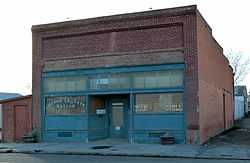
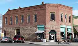
First Bank of Vale |
|
01992-03-05-0000March 5, 1992
(#92000132) |
148 Main St. S.
43°58′54″N 117°14′20″W / 43.981667°N 117.238889°W / 43.981667; -117.238889 (First Bank of Vale) |
Vale |
|
| 5 |
Green Lantern Saloon |
|
01996-09-06-0000September 6, 1996
(#96000980) |
11 S. 1st St.
43°52′35″N 116°59′35″W / 43.876389°N 116.993056°W / 43.876389; -116.993056 (Green Lantern Saloon) |
Nyssa |
|
| 6 |
Moses and Mary Hart Stone House and Ranch Complex |
|
02001-10-01-0000October 1, 2001
(#01000498) |
1 mile (1.6 km) west of Post Office on Bully Creek County Rd.
43°58′53″N 117°43′20″W / 43.981411°N 117.722343°W / 43.981411; -117.722343 (Moses and Mary Hart Stone House and Ranch Complex) |
Westfall |
|
| 7 |
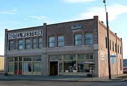
Hotel Western |
|
01996-09-06-0000September 6, 1996
(#96000981) |
9 Good Ave.
43°52′33″N 116°59′34″W / 43.875833°N 116.992778°W / 43.875833; -116.992778 (Hotel Western) |
Nyssa |
|
| 8 |
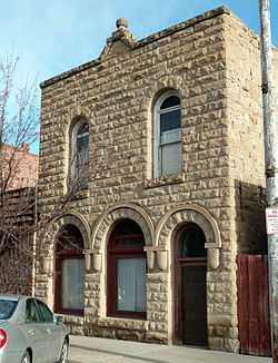
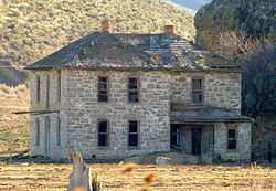
Old Stone House |
|
01972-05-19-0000May 19, 1972
(#72001085) |
283 S. Main St.
43°58′51″N 117°14′22″W / 43.980833°N 117.239444°W / 43.980833; -117.239444 (Old Stone House) |
Vale |
|
| 9 |
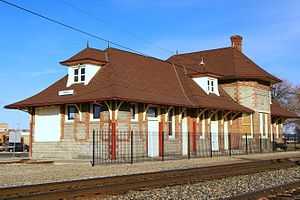
Oregon Short Line Railroad Depot |
|
01999-08-05-0000August 5, 1999
(#99000950) |
300 Depot Lane
44°01′26″N 116°57′42″W / 44.023889°N 116.961667°W / 44.023889; -116.961667 (Oregon Short Line Railroad Depot) |
Ontario |
|
| 10 |
Oregon Trail Historic District |
|
01975-10-29-0000October 29, 1975
(#75001589) |
5 miles (8.0 km) southeast of Vale at Lytle Blvd.
43°54′50″N 117°10′35″W / 43.913889°N 117.176389°W / 43.913889; -117.176389 (Oregon Trail Historic District) |
Vale |
|
| 11 |
Owyhee Dam Historic District |
|
02010-09-23-0000September 23, 2010
(#10000791) |
Owyhee Lake Road
43°35′31″N 117°14′33″W / 43.591825°N 117.242389°W / 43.591825; -117.242389 (Owyhee Dam Historic District) |
Adrian vicinity |
Historic district including Owyhee Dam
|
| 12 |
Pelota Fronton |
|
01972-05-19-0000May 19, 1972
(#72001084) |
Bassett St. (U.S. 95)
42°58′23″N 117°03′03″W / 42.973056°N 117.050833°W / 42.973056; -117.050833 (Pelota Fronton) |
Jordan Valley |
|
| 13 |
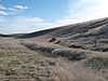
Sheep Ranch Fortified House |
Upload image |
01974-11-01-0000November 1, 1974
(#74001695) |
W of Arock
42°55′12″N 117°32′50″W / 42.919902°N 117.547140°W / 42.919902; -117.547140 (Sheep Ranch Fortified House) |
Arock vicinity |
|
| 14 |
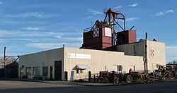
Al Thompson and Son's Feed and Seed Company |
|
01996-09-06-0000September 6, 1996
(#96000982) |
117 Good Ave.
43°52′33″N 116°59′38″W / 43.875833°N 116.993889°W / 43.875833; -116.993889 (Al Thompson and Son's Feed and Seed Company) |
Nyssa |
|
| 15 |
Vale Drug Store |
|
02002-09-06-0000September 6, 2002
(#02000950) |
158 Main St. N
43°58′56″N 117°14′20″W / 43.982222°N 117.238889°W / 43.982222; -117.238889 (Vale Drug Store) |
Vale |
|
| 16 |
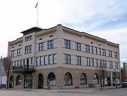
Vale Hotel and Grand Opera House |
|
01984-08-01-0000August 1, 1984
(#84003032) |
123 S. Main St.
43°58′56″N 117°14′43″W / 43.982222°N 117.245278°W / 43.982222; -117.245278 (Vale Hotel and Grand Opera House) |
Vale |
|
| 17 |
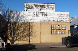
Vinsonhaler Blacksmith Shop |
|
01996-09-06-0000September 6, 1996
(#96000983) |
122 Good Ave.
43°52′34″N 116°59′38″W / 43.876111°N 116.993889°W / 43.876111; -116.993889 (Vinsonhaler Blacksmith Shop) |
Nyssa |
|
.jpg)

_(malD0081).jpg)
_(malD0117a).jpg)
_(malDA0101).jpg)
 Media related to National Register of Historic Places in Malheur County, Oregon at Wikimedia Commons