National Register of Historic Places listings in Madison County, Tennessee
Location of Madison County in Tennessee
This is a list of the National Register of Historic Places listings in Madison County, Tennessee.
This is intended to be a complete list of the properties and districts on the National Register of Historic Places in Madison County, Tennessee, United States. Latitude and longitude coordinates are provided for many National Register properties and districts; these locations may be seen together in a Google map.[1]
There are 28 properties and districts listed on the National Register in the county, including 1 National Historic Landmark.
| Anderson – Bedford – Benton – Bledsoe – Blount – Bradley – Campbell – Cannon – Carroll – Carter – Cheatham – Chester – Claiborne – Clay – Cocke – Coffee – Crockett – Cumberland – Davidson – Decatur – DeKalb – Dickson – Dyer – Fayette – Fentress – Franklin – Gibson – Giles – Grainger – Greene – Grundy – Hamblen – Hamilton – Hancock – Hardeman – Hardin – Hawkins – Haywood – Henderson – Henry – Hickman – Houston – Humphreys – Jackson – Jefferson – Johnson – Knox – Lake – Lauderdale – Lawrence – Lewis – Lincoln – Loudon – Macon – Madison – Marion – Marshall – Maury – McMinn – McNairy – Meigs – Monroe – Montgomery – Moore – Morgan – Obion – Overton – Perry – Pickett – Polk – Putnam – Rhea – Roane – Robertson – Rutherford – Scott – Sequatchie – Sevier – Shelby – Smith – Stewart – Sullivan – Sumner – Tipton – Trousdale – Unicoi – Union – Van Buren – Warren – Washington – Wayne – Weakley – White – Williamson – Wilson |
- This National Park Service list is complete through NPS recent listings posted May 1, 2015.[2]
Current listings
| [3] | Name on the Register[4] | Image | Date listed[5] | Location | City or town | Description |
|---|---|---|---|---|---|---|
| 1 | Anderson Presbyterian Church | Upload image | (#07000157) |
899 Steam Mill Ferry Rd. 35°33′42″N 88°52′22″W / 35.561667°N 88.872778°W |
Madison Hall | |
| 2 | Bemis Historic District | Upload image | (#91001777) |
Roughly bounded by D St., the Illinois Central railroad tracks, 6th St., and rural property lines to the west and south 35°34′23″N 88°49′31″W / 35.573056°N 88.825278°W |
Jackson | Includes the Bemis mill.[6] |
| 3 | The Cedars | Upload image | (#99000536) |
260 Cotton Grove Rd. 35°37′57″N 88°45′03″W / 35.6325°N 88.750833°W |
Jackson | |
| 4 | Deberry-Hurt House | Upload image | (#80003846) |
Southwest of Jackson 35°36′43″N 88°44′48″W / 35.611944°N 88.746667°W |
Jackson | |
| 5 | Denmark Mound Group | Upload image | (#92001656) |
Address Restricted |
Denmark | |
| 6 | Denmark Presbyterian Church | 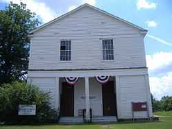 |
(#83003048) |
Jackson-Denmark Rd. 35°31′56″N 89°00′01″W / 35.532222°N 89.000278°W |
Denmark | |
| 7 | East Main Street Historic District | Upload image | (#80003847) |
Irregular pattern along E. Main St. 35°36′50″N 88°48′35″W / 35.613889°N 88.809722°W |
Jackson | |
| 8 | Capt. H. P. Farrar House | 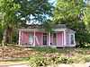 |
(#82003989) |
161 West Orleans St. 35°37′08″N 88°49′19″W / 35.618889°N 88.821944°W |
Jackson | |
| 9 | Greyhound Bus Station | 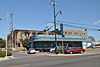 |
(#92001871) |
407 E. Main St. 35°36′52″N 88°48′58″W / 35.614444°N 88.816111°W |
Jackson | |
| 10 | William Holland, Jr., House | 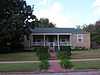 |
(#05000696) |
215 Roland Ave. 35°38′05″N 88°49′14″W / 35.634722°N 88.820556°W |
Jackson | |
| 11 | Hollywood Cemetery | 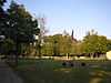 |
(#03000430) |
406 Hollywood Dr. 35°37′26″N 88°50′01″W / 35.623889°N 88.833611°W |
Jackson | |
| 12 | Illinois Central Railroad Division Office | Upload image | (#92001869) |
245 W. Sycamore St. 35°36′43″N 88°49′21″W / 35.611944°N 88.8225°W |
Jackson | |
| 13 | Jackson Free Library | 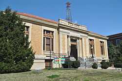 |
(#75001769) |
College and Church Sts. 35°36′58″N 88°49′01″W / 35.616111°N 88.816944°W |
Jackson | |
| 14 | Lane College Historic District | Upload image | (#87001117) |
Lane Ave.; also an area including the president's house and Lane Ave. to the original district boundary 35°37′41″N 88°48′26″W / 35.628056°N 88.807222°W |
Jackson | Second set of boundaries represents a boundary increase of November 8, 1991 |
| 15 | Madison County Courthouse | 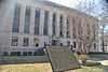 |
(#95000342) |
Public Sq. 35°36′49″N 88°49′10″W / 35.613611°N 88.819444°W |
Jackson | |
| 16 | Mt. Olivet Cemetery | Upload image | (#02000237) |
E. Forest Ave. 35°38′10″N 88°48′29″W / 35.636111°N 88.808056°W |
Jackson | |
| 17 | Murphy Hotel | Upload image | (#92001872) |
545 S. Royal St. 35°36′22″N 88°48′51″W / 35.606111°N 88.814167°W |
Jackson | |
| 18 | Nashville, Chattanooga & St. Louis Passenger Depot-Jackson | 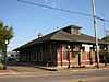 |
(#92001870) |
590 S. Royal St. 35°36′20″N 88°48′47″W / 35.605556°N 88.813056°W |
Jackson | |
| 19 | New Southern Hotel | 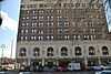 |
(#02001378) |
112-120 E. Baltimore St. 35°36′50″N 88°49′06″W / 35.613889°N 88.818333°W |
Jackson | |
| 20 | Northwood Avenue Historic District | Upload image | (#90001659) |
1-38 Northwood Ave. 35°37′52″N 88°48′55″W / 35.631111°N 88.815278°W |
Jackson | |
| 21 | Oakslea Place | 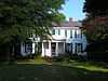 |
(#03001305) |
1210 N. Highland Ave. 35°37′58″N 88°49′05″W / 35.632778°N 88.818056°W |
Jackson | |
| 22 | Pinson Mounds | 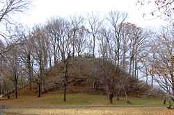 |
(#66000727) |
460 Ozier Rd.[7] 35°30′00″N 88°41′48″W / 35.5°N 88.6967°W |
Pinson | |
| 23 | Riverside Cemetery | Upload image | (#03000394) |
300 Riverside Dr. 35°36′38″N 88°49′31″W / 35.610556°N 88.825278°W |
Jackson | |
| 24 | Ross-Sewell House | Upload image | (#83003049) |
909 Highland Ave. 35°37′42″N 88°49′08″W / 35.628333°N 88.818889°W |
Jackson | |
| 25 | St. Luke Episcopal Church | Upload image | (#84003600) |
309 E. Baltimore St. 35°36′49″N 88°49′01″W / 35.613611°N 88.816944°W |
Jackson | |
| 26 | Southern Engine and Boiler Works | |
(#92001868) |
342 N. Royal St. 35°37′05″N 88°48′46″W / 35.618056°N 88.812778°W |
Jackson | |
| 27 | Temple B'Nai Israel | 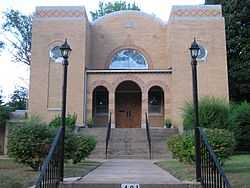 |
(#08000687) |
401 W. Grand St. Coordinates missing |
Jackson | |
| 28 | William Kirby Walsh House | 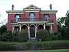 |
(#93001374) |
204 E. Deaderick St. 35°37′11″N 88°48′55″W / 35.619722°N 88.815278°W |
Jackson |
Former listings
| [3] | Name on the Register | Image | Date listed | Date removed | Location | City or town | Summary |
|---|---|---|---|---|---|---|---|
| 1 | Casey Jones Home and Railroad Museum | Upload image | (#72001244) | 211 W. Chester St. |
Jackson |
See also
| Wikimedia Commons has media related to National Register of Historic Places in Madison County, Tennessee. |
- List of National Historic Landmarks in Tennessee
- National Register of Historic Places listings in Tennessee
References
- ↑ The latitude and longitude information provided in this table was derived originally from the National Register Information System, which has been found to be fairly accurate for about 99% of listings. For about 1% of NRIS original coordinates, experience has shown that one or both coordinates are typos or otherwise extremely far off; some corrections may have been made. A more subtle problem causes many locations to be off by up to 150 yards, depending on location in the country: most NRIS coordinates were derived from tracing out latitude and longitudes off of USGS topographical quadrant maps created under the North American Datum of 1927, which differs from the current, highly accurate WGS84 GPS system used by most on-line maps. Chicago is about right, but NRIS longitudes in Washington are higher by about 4.5 seconds, and are lower by about 2.0 seconds in Maine. Latitudes differ by about 1.0 second in Florida. Some locations in this table may have been corrected to current GPS standards.
- ↑ "National Register of Historic Places: Weekly List Actions". National Park Service, United States Department of the Interior. Retrieved on May 1, 2015.
- ↑ 3.0 3.1 Numbers represent an ordering by significant words. Various colorings, defined here, differentiate National Historic Landmarks and historic districts from other NRHP buildings, structures, sites or objects.
- ↑ "National Register Information System". National Register of Historic Places. National Park Service. 2008-04-24.
- ↑ The eight-digit number below each date is the number assigned to each location in the National Register Information System database, which can be viewed by clicking the number.
- ↑ Tennessee Historical Commission, The Courier, Vol . XLIX, No. 2, June 2011, page 15
- ↑ Location derived from this Tennessee Department of Environment and Conservation website; the NRIS lists the site as "Address Restricted"
| ||||||||||||||||||||||||||
| |||||||||||||||||||||