National Register of Historic Places listings in Macon County, Georgia
This is a list of properties and districts in Macon County, Georgia that are listed on the National Register of Historic Places (NRHP).
- This National Park Service list is complete through NPS recent listings posted May 1, 2015.[1]
Current listings
| [2] |
Name on the Register |
Image |
Date listed[3] |
Location |
City or town |
Description |
|---|
| 1 |
Alma Fruit Farm |
Upload image |
01980-11-25-0000November 25, 1980
(#80004446) |
GA 49W
Coordinates missing |
Marshallville |
|
| 2 |
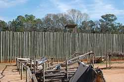
Andersonville National Historic Site |
|
01970-10-16-0000October 16, 1970
(#70000070) |
1 mi. E of Andersonville on GA 49
32°12′23″N 84°07′24″W / 32.206389°N 84.123333°W / 32.206389; -84.123333 (Andersonville National Historic Site) |
Andersonville |
|
| 3 |
Billy Place |
Upload image |
01980-11-25-0000November 25, 1980
(#80004444) |
Rt. 1
32°25′10″N 83°57′44″W / 32.419444°N 83.962222°W / 32.419444; -83.962222 (Billy Place) |
Marshallville |
|
| 4 |
DeVaughn-Lewis House |
Upload image |
01985-05-02-0000May 2, 1985
(#85000937) |
510 S. Dooly St.
32°17′38″N 84°01′53″W / 32.293889°N 84.031389°W / 32.293889; -84.031389 (DeVaughn-Lewis House) |
Montezuma |
|
| 5 |
East Main Street Residential District |
Upload image |
01980-11-25-0000November 25, 1980
(#80004454) |
E. Main St.
32°27′18″N 83°56′12″W / 32.455°N 83.936667°W / 32.455; -83.936667 (East Main Street Residential District) |
Marshallville |
|
| 6 |
William Hamilton Felton House |
Upload image |
01980-11-25-0000November 25, 1980
(#80004447) |
McCaskill St.
32°26′53″N 83°56′57″W / 32.448056°N 83.949167°W / 32.448056; -83.949167 (William Hamilton Felton House) |
Marshallville |
|
| 7 |
Wilkes Knob Plantation |
Upload image |
01980-11-25-0000November 25, 1980
(#80004451) |
Rt. 1
32°28′22″N 83°52′36″W / 32.472778°N 83.876667°W / 32.472778; -83.876667 (Wilkes Knob Plantation) |
Marshallville |
|
| 8 |
Lamson-Richardson School |
Upload image |
01981-05-18-0000May 18, 1981
(#81000697) |
Railroad St.
32°26′49″N 83°56′40″W / 32.446944°N 83.944444°W / 32.446944; -83.944444 (Lamson-Richardson School) |
Marshallville |
|
| 9 |
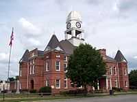
Macon County Courthouse |
|
01980-09-18-0000September 18, 1980
(#80001113) |
Courthouse Sq.
32°17′35″N 84°03′37″W / 32.293056°N 84.060278°W / 32.293056; -84.060278 (Macon County Courthouse) |
Oglethorpe |
|
| 10 |
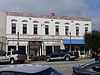
Marshallville Commercial District |
Upload image |
01980-11-25-0000November 25, 1980
(#80004452) |
Main St.
32°27′23″N 83°55′24″W / 32.456389°N 83.923333°W / 32.456389; -83.923333 (Marshallville Commercial District) |
Marshallville |
|
| 11 |
Massee Lane |
Upload image |
01980-11-25-0000November 25, 1980
(#80004450) |
Rt. 1
32°29′21″N 83°56′09″W / 32.489167°N 83.935833°W / 32.489167; -83.935833 (Massee Lane) |
Marshallville |
|
| 12 |
Montezuma Depot |
|
01980-06-12-0000June 12, 1980
(#80001112) |
S. Dooly St.
32°18′02″N 84°01′46″W / 32.300556°N 84.029444°W / 32.300556; -84.029444 (Montezuma Depot) |
Montezuma |
|
| 13 |
Montezuma Historic District |
|
02003-10-13-0000October 13, 2003
(#03001017) |
Roughly centered along N. and S. Dooly St.
32°18′11″N 84°01′47″W / 32.303056°N 84.029722°W / 32.303056; -84.029722 (Montezuma Historic District) |
Montezuma |
|
| 14 |
Thronateeska |
Upload image |
01980-11-25-0000November 25, 1980
(#80004445) |
Rt. 1
32°25′04″N 84°00′51″W / 32.417778°N 84.014167°W / 32.417778; -84.014167 (Thronateeska) |
Marshallville |
|
| 15 |
West Main Street Residential District |
Upload image |
01980-11-25-0000November 25, 1980
(#80004453) |
W. Main St.
32°27′21″N 83°56′59″W / 32.455833°N 83.949722°W / 32.455833; -83.949722 (West Main Street Residential District) |
Marshallville |
|
| 16 |
Willow Lake |
Upload image |
01980-11-25-0000November 25, 1980
(#80004449) |
Rt. 1
32°28′36″N 83°53′32″W / 32.476667°N 83.892222°W / 32.476667; -83.892222 (Willow Lake) |
Marshallville |
|
References
Rose Hill Cemetery
.JPG)