National Register of Historic Places listings in Macon County, Alabama
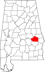
Location of Macon County in Alabama
This is a list of the National Register of Historic Places listings in Macon County, Alabama.
This is intended to be a complete list of the properties and districts on the National Register of Historic Places in Macon County, Alabama, United States. Latitude and longitude coordinates are provided for many National Register properties and districts; these locations may be seen together in a Google map.[1]
There are 12 properties and districts listed on the National Register in the county, including 1 National Historic Landmark, the Tuskeegee Institute.
- This National Park Service list is complete through NPS recent listings posted May 1, 2015.[2]
Current listings
| [3] | Name on the Register | Image | Date listed[4] | Location | City or town | Description |
|---|---|---|---|---|---|---|
| 1 | Archeological Site No. 1MC110 |  |
(#85003118) |
Address Restricted |
Tuskegee | |
| 2 | Atasi Site | |
(#77000210) |
Address Restricted |
Shorter | |
| 3 | Butler Chapel African Methodist Episcopal Zion Church | 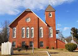 |
(#95001022) |
1002 N. Church St. 32°25′07″N 85°41′58″W / 32.418611°N 85.699444°W |
Tuskegee | |
| 4 | Creekwood |  |
(#89000310) |
Society Hill Rd., 0.4 miles (0.64 km) north of County Highway 10 32°18′00″N 85°28′46″W / 32.3°N 85.479444°W |
Creek Stand | Circa 1844 |
| 5 | Grey Columns | 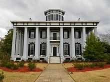 |
(#80000364) |
399 Old Montgomery Rd. 32°25′27″N 85°41′59″W / 32.424291°N 85.699596°W |
Tuskegee | Built in 1857, Grey Columns now serves as the home of the president of Tuskegee University. |
| 6 | Macon County Courthouse |  |
(#78000495) |
E. Northside and N. Main Sts. 32°25′28″N 85°41′27″W / 32.424444°N 85.690833°W |
Tuskegee | |
| 7 | Main Street Historic District | 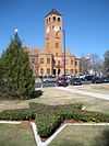 |
(#84000650) |
Main St. 32°25′22″N 85°41′23″W / 32.422778°N 85.689722°W |
Tuskegee | |
| 8 | North Main Street Historic District | 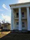 |
(#85000445) |
600, 615, and 616 N. Main, 101 and 110 E. Water, 700 Water, 701 Maple, and 811 N. Maple Sts. 32°25′46″N 85°41′40″W / 32.429444°N 85.694444°W |
Tuskegee | |
| 9 | Shiloh Missionary Baptist Church and Rosenwald School | 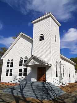 |
(#10000522) |
7 Shiloh Rd. 32°31′24″N 85°40′05″W / 32.523333°N 85.668056°W |
Notasulga | |
| 10 | Tuskegee Airmen National Historic Site |  |
(#01000284) |
c/o Tuskegee Institute, PO Drawer 10 Coordinates missing |
Tuskegee | |
| 11 | Tuskegee Institute National Historic Site |  |
(#66000151) |
1 mile (1.6 km) northwest of Tuskegee on U.S. Route 80 Coordinates missing |
Tuskegee | |
| 12 | Tuskegee Veterans Administration Hospital | Upload image | (#12000140) |
2400 Hospital Rd. 32°26′43″N 85°42′47″W / 32.445157°N 85.713083°W |
Tuskegee | part of the United States Second Generation Veterans Hospitals Multiple Property Submission |
See also
| Wikimedia Commons has media related to National Register of Historic Places in Macon County, Alabama. |
- List of National Historic Landmarks in Alabama
- National Register of Historic Places listings in Alabama
References
- ↑ The latitude and longitude information provided in this table was derived originally from the National Register Information System, which has been found to be fairly accurate for about 99% of listings. For about 1% of NRIS original coordinates, experience has shown that one or both coordinates are typos or otherwise extremely far off; some corrections may have been made. A more subtle problem causes many locations to be off by up to 150 yards, depending on location in the country: most NRIS coordinates were derived from tracing out latitude and longitudes off of USGS topographical quadrant maps created under the North American Datum of 1927, which differs from the current, highly accurate WGS84 GPS system used by most on-line maps. Chicago is about right, but NRIS longitudes in Washington are higher by about 4.5 seconds, and are lower by about 2.0 seconds in Maine. Latitudes differ by about 1.0 second in Florida. Some locations in this table may have been corrected to current GPS standards.
- ↑ "National Register of Historic Places: Weekly List Actions". National Park Service, United States Department of the Interior. Retrieved on May 1, 2015.
- ↑ Numbers represent an ordering by significant words. Various colorings, defined here, differentiate National Historic Landmarks and historic districts from other NRHP buildings, structures, sites or objects.
- ↑ The eight-digit number below each date is the number assigned to each location in the National Register Information System database, which can be viewed by clicking the number.
| |||||||||||||||||||||


| |||||||||||||||||||||||||