National Register of Historic Places listings in Lonoke County, Arkansas

Location of Lonoke County in Arkansas
This is a list of the National Register of Historic Places listings in Lonoke County, Arkansas.
This is intended to be a complete list of the properties and districts on the National Register of Historic Places in Lonoke County, Arkansas, United States. The locations of National Register properties and districts for which the latitude and longitude coordinates are included below, may be seen in a Google map.[1]
There are 30 properties and districts listed on the National Register in the county, including 1 National Historic Landmark. Another property was once listed but has been removed.
- This National Park Service list is complete through NPS recent listings posted May 1, 2015.[2]
Current listings
| [3] | Name on the Register[4] | Image | Date listed[5] | Location | City or town | Description |
|---|---|---|---|---|---|---|
| 1 | Ashley-Alexander House | Upload image | (#76000431) |
North of Scott 34°42′21″N 92°05′33″W / 34.705833°N 92.0925°W |
Scott | |
| 2 | Thomas Sloan Boyd House | Upload image | (#76000430) |
220 Park Ave. 34°46′55″N 91°54′07″W / 34.781944°N 91.901944°W |
Lonoke | |
| 3 | Camp Nelson Confederate Cemetery | 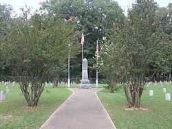 |
(#96000503) |
Rye St., approximately 1 mile northwest of the junction of Highways 319 and 321 34°56′46″N 91°58′49″W / 34.946111°N 91.980278°W |
Cabot | |
| 4 | Carlisle Rock Island Depot | Upload image | (#90000905) |
Junction of Main St. and Court Ave. 34°46′58″N 91°44′46″W / 34.782778°N 91.746111°W |
Carlisle | |
| 5 | Carver Gymnasium | Upload image | (#09000741) |
400 Ferguson St. 34°46′51″N 91°53′47″W / 34.780875°N 91.896497°W |
Lonoke | |
| 6 | Coy Mound Site | Upload image | (#95001120) |
Address Restricted |
Coy | |
| 7 | Dortch Plantation | Upload image | (and 79003777&natregadvancedsearch=Search #75000397 and 79003777) |
Northeast of Scott off Highway 130 at Bearskin Lake 34°42′55″N 92°03′13″W / 34.715278°N 92.053611°W |
Scott | |
| 8 | Eagle House | Upload image | (#82000858) |
217 Ash St. 34°46′57″N 91°54′06″W / 34.7825°N 91.901667°W |
Lonoke | |
| 9 | Joe P. Eagle and D. R. Boone Building | Upload image | (#94001462) |
105-107 W. Front St. 34°47′01″N 91°54′01″W / 34.783611°N 91.900278°W |
Lonoke | |
| 10 | First Christian Church | Upload image | (#97000748) |
Junction of 2nd and Depot Sts. 34°47′07″N 91°54′04″W / 34.785278°N 91.901111°W |
Lonoke | |
| 11 | First Presbyterian Church | 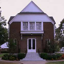 |
(#04001037) |
304 S. Center St. 34°46′53″N 91°54′01″W / 34.781389°N 91.900278°W |
Lonoke | |
| 12 | W.P. Fletcher House | Upload image | (#90001373) |
604 W. 4th St. 34°47′14″N 91°54′19″W / 34.787222°N 91.905278°W |
Lonoke | |
| 13 | Keo Commercial Historic District |  |
(#11000355) |
Main & Fleming Sts., Arkansas Highway 232 34°36′02″N 92°00′33″W / 34.600556°N 92.009167°W |
Keo | Cotton and Rice Farm History and Architecture in the Arkansas Delta MPS |
| 14 | Lonoke Confederate Monument | Upload image | (#96000508) |
On the courthouse lawn, near the junction of 3rd and Center Sts. 34°47′09″N 91°53′58″W / 34.785833°N 91.899444°W |
Lonoke | |
| 15 | Lonoke County Courthouse | Upload image | (#82002121) |
N. Center St. 34°47′09″N 91°53′57″W / 34.785833°N 91.899167°W |
Lonoke | |
| 16 | Lonoke Downtown Historic District | 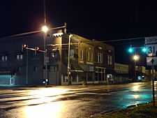 |
(#96000528) |
Junction of Front and Center Sts. 34°47′05″N 91°53′58″W / 34.784722°N 91.899444°W |
Lonoke | |
| 17 | Memphis to Little Rock Road-Bayou Two Prairie Segment | Upload image | (#06000836) |
Address Restricted |
Brownsville | A segment of the Trail of Tears[6] |
| 18 | Memphis to Little Rock Road-Brownsville Segment | Upload image | (#03000954) |
Address Restricted |
Brownsville | A segment of the Trail of Tears[6] |
| 19 | Rock Island Depot | Upload image | (#84000006) |
U.S. Route 70 and Center St. 34°47′02″N 91°54′02″W / 34.783889°N 91.900556°W |
Lonoke | |
| 20 | Sears House | Upload image | (#92000952) |
Southeast of the junction of Highways 38 and 319 34°59′05″N 91°57′43″W / 34.984722°N 91.961944°W |
Austin | |
| 21 | Shull House | Upload image | (#82000859) |
418 Park 34°46′48″N 91°54′05″W / 34.78°N 91.901389°W |
Lonoke | |
| 22 | Toltec Mounds | 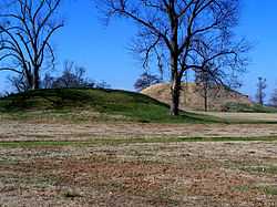 |
(#73000382) |
Address Restricted |
Scott | |
| 23 | Trimble House | Upload image | (#82000860) |
518 Center St. 34°46′46″N 91°53′59″W / 34.779444°N 91.899722°W |
Lonoke | |
| 24 | Trimble-McCrary House | Upload image | (#04001038) |
516 Jefferson 34°46′45″N 91°54′10″W / 34.779167°N 91.902778°W |
Lonoke | |
| 25 | US 70, Union Valley Segment | Upload image | (#04001040) |
North and south of U.S. Route 70 from the S28/S29 boundary line R9W west to the S26/S27 boundary line R10W 34°45′56″N 92°01′25″W / 34.765556°N 92.023611°W |
Union Valley | |
| 26 | Dr. E.F. Utley House |  |
(#98000623) |
401 W. Pine St. 35°00′43″N 92°01′04″W / 35.011944°N 92.017778°W |
Cabot | |
| 27 | Walls Farm Barn and Corn Crib | Upload image | (#95001379) |
Highway 31 north of Tomberlin 34°31′26″N 91°52′26″W / 34.523889°N 91.873889°W |
Tomberlin | |
| 28 | Walls House | Upload image | (#82000861) |
406 Jefferson St. 34°46′49″N 91°54′12″W / 34.780278°N 91.903333°W |
Lonoke | |
| 29 | Wheat House | Upload image | (#82000862) |
600 Center St. 34°46′43″N 91°53′59″W / 34.778611°N 91.899722°W |
Lonoke | |
| 30 | Woodlawn School Building | Upload image | (#93000086) |
Northwest of the junction of Highway 31 and Bizzell Rd. 34°55′22″N 91°52′30″W / 34.922778°N 91.875°W |
Woodlawn |
Former listing
| [3] | Name on the Register | Image | Date listed | Date removed | Location | City or town | Summary |
|---|---|---|---|---|---|---|---|
| 1 | St. Louis Southwest Railway (Cotton Belt Route) Depot | Upload image | (#03001459) | Main St. (Highway 31) |
Coy |
See also
| Wikimedia Commons has media related to National Register of Historic Places in Lonoke County, Arkansas. |
- List of National Historic Landmarks in Arkansas
- National Register of Historic Places listings in Arkansas
References
- ↑ The latitude and longitude information provided in this table was derived originally from the National Register Information System, which has been found to be fairly accurate for about 99% of listings. For about 1% of NRIS original coordinates, experience has shown that one or both coordinates are typos or otherwise extremely far off; some corrections may have been made. A more subtle problem causes many locations to be off by up to 150 yards, depending on location in the country: most NRIS coordinates were derived from tracing out latitude and longitudes off of USGS topographical quadrant maps created under the North American Datum of 1927, which differs from the current, highly accurate WGS84 GPS system used by most on-line maps. Chicago is about right, but NRIS longitudes in Washington are higher by about 4.5 seconds, and are lower by about 2.0 seconds in Maine. Latitudes differ by about 1.0 second in Florida. Some locations in this table may have been corrected to current GPS standards.
- ↑ "National Register of Historic Places: Weekly List Actions". National Park Service, United States Department of the Interior. Retrieved on May 1, 2015.
- ↑ 3.0 3.1 Numbers represent an ordering by significant words. Various colorings, defined here, differentiate National Historic Landmarks and historic districts from other NRHP buildings, structures, sites or objects.
- ↑ "National Register Information System". National Register of Historic Places. National Park Service. 2009-03-13.
- ↑ The eight-digit number below each date is the number assigned to each location in the National Register Information System database, which can be viewed by clicking the number.
- ↑ 6.0 6.1 "Trail Of Tears National Historic Trail: National Register Research". National Park Service. Retrieved January 22, 2013.
| ||||||||||||||||||||||||||
| |||||||||||||||||||||||||||||||||