National Register of Historic Places listings in Lincoln County, Wyoming

Location of Lincoln County in Wyoming
This is a list of the National Register of Historic Places listings in Lincoln County, Wyoming.
It is intended to be a complete list of the properties and districts on the National Register of Historic Places in Lincoln County, Wyoming, United States. The locations of National Register properties and districts for which the latitude and longitude coordinates are included below, may be seen in a Google map.[1]
There are 12 properties and districts listed on the National Register in the county, 1 of which is a National Historic Landmark. Another property was previously listed on the National Register but has been removed.
- This National Park Service list is complete through NPS recent listings posted May 1, 2015.[2]
Current listings
| [3] |
Name on the Register |
Image |
Date listed[4] |
Location |
City or town |
Description |
|---|
| 1 |
Emigrant Springs |
Upload image |
01976-01-11-0000January 11, 1976
(#76001956) |
Approximately 18 miles (29 km) west of Fontenelle[5]
41°58′39″N 110°24′23″W / 41.9775°N 110.406389°W / 41.9775; -110.406389 (Emigrant Springs) |
Kemmerer |
|
| 2 |
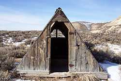
Haddenham Cabin |
|
02003-12-23-0000December 23, 2003
(#03001339) |
Fossil Butte National Monument
41°49′49″N 110°43′52″W / 41.830278°N 110.731111°W / 41.830278; -110.731111 (Haddenham Cabin) |
Kemmerer |
|
| 3 |
Fossil Oregon Short Line Depot |
Upload image |
02013-12-11-0000December 11, 2013
(#13000919) |
Approx. .4 mi. WNW. of the Jct. of US 30 & Cty. Rd. 300
41°49′00″N 110°43′36″W / 41.816779°N 110.726537°W / 41.816779; -110.726537 (Fossil Oregon Short Line Depot) |
Kemmerer |
|
| 4 |
Johnston Scout Rocks |
Upload image |
01976-11-07-0000November 7, 1976
(#76001957) |
Approximately 1 mile (1.6 km) south of Emigrant Springs[6]
41°57′56″N 110°24′32″W / 41.96544°N 110.40877°W / 41.96544; -110.40877 (Johnston Scout Rocks) |
Kemmerer |
|
| 5 |
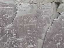
La Barge Bluffs Petroglyphs |
Upload image |
02014-04-07-0000April 7, 2014
(#14000134) |
Address Restricted
|
La Barge vicinity |
|
| 6 |
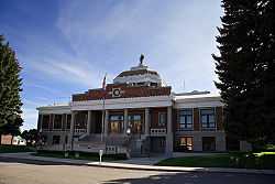
Lincoln County Courthouse |
|
01984-11-08-0000November 8, 1984
(#84000385) |
Sage Ave. and Garnet St.
41°47′33″N 110°32′24″W / 41.7925°N 110.54°W / 41.7925; -110.54 (Lincoln County Courthouse) |
Kemmerer |
|
| 7 |
Names Hill |
|
01969-04-16-0000April 16, 1969
(#69000193) |
On the Green River, 5 mi (8.0 km) south of LaBarge and west of U.S. Route 189
42°09′03″N 110°11′04″W / 42.150833°N 110.184444°W / 42.150833; -110.184444 (Names Hill) |
La Barge |
|
| 8 |
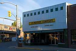
J. C. Penney Historic District |
|
01978-06-02-0000June 2, 1978
(#78002830) |
J.C. Penney Ave. and S. Main St.
41°47′41″N 110°32′09″W / 41.794722°N 110.535833°W / 41.794722; -110.535833 (J. C. Penney Historic District) |
Kemmerer |
|
| 9 |
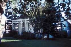
J.C. Penney House |
|
01976-06-18-0000June 18, 1976
(#76001958) |
Railroad Park
41°47′43″N 110°32′08″W / 41.795278°N 110.535556°W / 41.795278; -110.535556 (J.C. Penney House) |
Kemmerer |
|
| 10 |
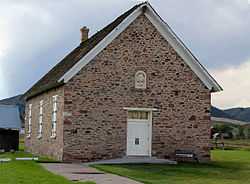
Rock Church |
|
01985-12-13-0000December 13, 1985
(#85003222) |
2nd W. and 1st S. Sts.
42°47′30″N 111°00′04″W / 42.791667°N 111.001111°W / 42.791667; -111.001111 (Rock Church) |
Auburn |
|
| 11 |
Salt River Hydroelectric Powerplant |
Upload image |
01993-12-02-0000December 2, 1993
(#93000889) |
End of County Road 12-104, 0.7 miles west of U.S. Route 89
43°06′14″N 111°02′20″W / 43.103889°N 111.038889°W / 43.103889; -111.038889 (Salt River Hydroelectric Powerplant) |
Etna |
Extends into Bonneville County, Idaho
|
| 12 |
US Post Office-Kemmerer Main |
Upload image |
01987-05-19-0000May 19, 1987
(#87000786) |
318 Sapphire St.
41°47′40″N 110°32′18″W / 41.794444°N 110.538333°W / 41.794444; -110.538333 (US Post Office-Kemmerer Main) |
Kemmerer |
|
Former listings
See also
References
- ↑ The latitude and longitude information provided in this table was derived originally from the National Register Information System, which has been found to be fairly accurate for about 99% of listings. For about 1% of NRIS original coordinates, experience has shown that one or both coordinates are typos or otherwise extremely far off; some corrections may have been made. A more subtle problem causes many locations to be off by up to 150 yards, depending on location in the country: most NRIS coordinates were derived from tracing out latitude and longitudes off of USGS topographical quadrant maps created under the North American Datum of 1927, which differs from the current, highly accurate WGS84 GPS system used by most on-line maps. Chicago is about right, but NRIS longitudes in Washington are higher by about 4.5 seconds, and are lower by about 2.0 seconds in Maine. Latitudes differ by about 1.0 second in Florida. Some locations in this table may have been corrected to current GPS standards.
- ↑ "National Register of Historic Places: Weekly List Actions". National Park Service, United States Department of the Interior. Retrieved on May 1, 2015.
- ↑ 3.0 3.1 Numbers represent an ordering by significant words. Various colorings, defined here, differentiate National Historic Landmarks and historic districts from other NRHP buildings, structures, sites or objects.
- ↑ The eight-digit number below each date is the number assigned to each location in the National Register Information System database, which can be viewed by clicking the number.
- ↑ Location derived from this Wyoming State Historic Preservation Office webpage, and coordinates derived from its GNIS feature record; the NRIS lists the site as "Address Restricted"
- ↑ Location derived from this Wyoming State Historic Preservation Office webpage; the NRIS lists the site as "Address Restricted"
|
|---|
| | Topics | |
|---|
| | Lists by states | |
|---|
| | Lists by insular areas | |
|---|
| | Lists by associated states | |
|---|
| | Other areas | |
|---|
|
-
 Category Category
-
 Portal Portal
-
 WikiProject WikiProject
|
|