| [3] |
Name on the Register[4] |
Image |
Date listed[5] |
Location |
City or town |
Description |
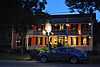
|---|
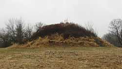
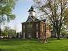
| 1 |
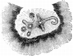
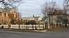
Alligator Effigy Mound |
|
01971-11-05-0000November 5, 1971
(#71000643) |
End of Bryn Du Dr.[6]
40°04′12″N 82°30′04″W / 40.07°N 82.5011°W / 40.07; -82.5011 (Alligator Effigy Mound) |
Granville |
|
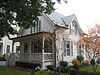
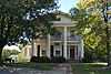
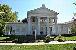
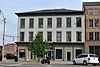
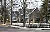
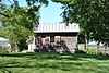
| 2 |
Avery-Hunter House |
|
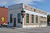
01979-12-27-0000December 27, 1979
(#79001877) |
221 E. Broadway
40°04′03″N 82°31′04″W / 40.0675°N 82.517778°W / 40.0675; -82.517778 (Avery-Hunter House) |
Granville |
|
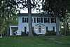
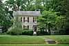
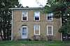
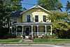
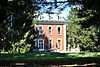
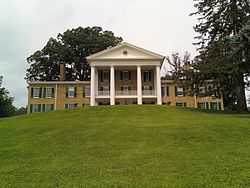
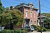
| 3 |
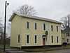
A.A. Bancroft House |
|
01980-11-28-0000November 28, 1980
(#80003135) |
N. Pearl St. and Washington Dr.
40°04′27″N 82°31′06″W / 40.074167°N 82.518333°W / 40.074167; -82.518333 (A.A. Bancroft House) |
Granville |
|
| 4 |
Belle Hall Covered Bridge |
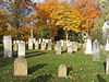
Upload image |
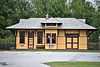
01976-10-22-0000October 22, 1976
(#76001464) |
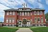
East of Hartford on Dutch Cross Rd.
40°14′08″N 82°38′26″W / 40.235556°N 82.640556°W / 40.235556; -82.640556 (Belle Hall Covered Bridge) |
Bennington Township |
|
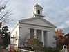
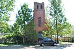
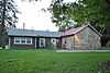
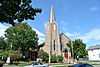
| 5 |
Bethel Baptist Church |
|
01983-09-22-0000September 22, 1983
(#83001990) |
Vine and Cedar Sts.
40°00′00″N 82°40′40″W / 40.0°N 82.677778°W / 40.0; -82.677778 (Bethel Baptist Church) |
Pataskala |
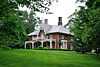
|
| 6 |
Bryn Mawr |
Upload image |
01983-03-29-0000March 29, 1983
(#83001991) |
3758 Lancaster Rd., SW., south of Granville
40°02′07″N 82°31′26″W / 40.035278°N 82.523889°W / 40.035278; -82.523889 (Bryn Mawr) |
Union Township |
|
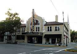
| 7 |
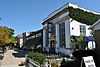
Buxton Inn |
|
01972-12-26-0000December 26, 1972
(#72001029) |
313 E. Broadway
40°04′03″N 82°30′58″W / 40.0675°N 82.516111°W / 40.0675; -82.516111 (Buxton Inn) |
Granville |
|
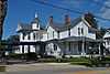
| 8 |
Wallace W. Carpenter House |
|
01980-11-28-0000November 28, 1980
(#80003136) |
323 Summit Dr.
40°04′11″N 82°30′57″W / 40.069722°N 82.515833°W / 40.069722; -82.515833 (Wallace W. Carpenter House) |
Granville |
|
| 9 |
Casterton House |
|
01983-09-22-0000September 22, 1983
(#83001992) |
105 Broadway
39°59′37″N 82°40′42″W / 39.993611°N 82.678333°W / 39.993611; -82.678333 (Casterton House) |
Pataskala |
|
| 10 |
Cedar Hill Cemetery Buildings |
|
01977-04-13-0000April 13, 1977
(#77001071) |
Cedar St.
40°04′04″N 82°23′10″W / 40.067778°N 82.386111°W / 40.067778; -82.386111 (Cedar Hill Cemetery Buildings) |
Newark |
|
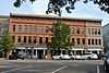
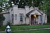
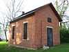
| 11 |
Courthouse Center |
|
01979-11-29-0000November 29, 1979
(#79001879) |
35-37 S. Park Pl. and junction of S. Park and S. 2nd St.
40°03′26″N 82°24′03″W / 40.057222°N 82.400833°W / 40.057222; -82.400833 (Courthouse Center) |
Newark |
|
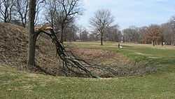
| 12 |
Dixon Mound |
|
01973-06-04-0000June 4, 1973
(#73001494) |
Next to the Homer Public Library in Homer[7]
40°15′05″N 82°31′28″W / 40.2515°N 82.5245°W / 40.2515; -82.5245 (Dixon Mound) |
Burlington Township |
|
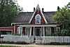
| 13 |
Dustin Cabin |
|
01980-11-28-0000November 28, 1980
(#80003137) |
597 N. Pearl St.
40°04′30″N 82°31′08″W / 40.075°N 82.518889°W / 40.075; -82.518889 (Dustin Cabin) |
Granville |
|
| 14 |
Elliot House |
|
01983-11-14-0000November 14, 1983
(#83004315) |
301 S. Main St.
39°59′49″N 82°40′32″W / 39.996944°N 82.675556°W / 39.996944; -82.675556 (Elliot House) |
Pataskala |
|
| 15 |
Etna Township Mounds I And II |
Upload image |
01975-09-05-0000September 5, 1975
(#75001457) |
East of Reynoldsburg off Interstate 70[8]
|
Etna Township |
|
| 16 |
Evans-Holton-Owens House |
|
01986-10-16-0000October 16, 1986
(#86002874) |
162 W. Locust St.
40°03′32″N 82°24′38″W / 40.058889°N 82.410556°W / 40.058889; -82.410556 (Evans-Holton-Owens House) |
Newark |
Destroyed by fire in 2009[9]
|
| 17 |
Flint Ridge State Memorial |
|
01970-11-10-0000November 10, 1970
(#70000505) |
2 mi (3.2 km) north of Brownsville
39°59′10″N 82°16′04″W / 39.986111°N 82.267778°W / 39.986111; -82.267778 (Flint Ridge State Memorial) |
Hopewell Township |
|
| 18 |
Fuller House |
|
01991-03-22-0000March 22, 1991
(#91000304) |
203 N. Main St.
40°14′13″N 82°27′10″W / 40.237°N 82.452667°W / 40.237; -82.452667 (Fuller House) |
Utica |
|
| 19 |
Granville Historic District |
|
01980-11-28-0000November 28, 1980
(#80003138) |
State Route 37
40°04′04″N 82°31′10″W / 40.067778°N 82.519444°W / 40.067778; -82.519444 (Granville Historic District) |
Granville |
|
| 20 |
Home Building Association Bank |
|
01973-07-02-0000July 2, 1973
(#73001495) |
6 W. Main St.
40°03′28″N 82°24′09″W / 40.057778°N 82.4025°W / 40.057778; -82.4025 (Home Building Association Bank) |
Newark |
|
| 21 |
Hudson Avenue Historic District |
|
01987-03-18-0000March 18, 1987
(#86003506) |
Hudson Ave. between Stevens St. and State Route 16
40°04′10″N 82°24′30″W / 40.069444°N 82.408333°W / 40.069444; -82.408333 (Hudson Avenue Historic District) |
Newark |
|
| 22 |
Hull Place |
|
01979-12-21-0000December 21, 1979
(#79001880) |
686 W. Main St.
40°03′08″N 82°25′43″W / 40.052222°N 82.428611°W / 40.052222; -82.428611 (Hull Place) |
Newark |
|
| 23 |
Johnstown Jail |
|
02003-04-18-0000April 18, 2003
(#03000274) |
66 W. Pratt St.
40°09′06″N 82°41′08″W / 40.151667°N 82.685444°W / 40.151667; -82.685444 (Johnstown Jail) |
Johnstown |
|
| 24 |
Warren F. Kauber Funeral Home |
|
01983-09-22-0000September 22, 1983
(#83001993) |
289 S. Main St.
39°59′50″N 82°40′32″W / 39.997222°N 82.675556°W / 39.997222; -82.675556 (Warren F. Kauber Funeral Home) |
Pataskala |
|
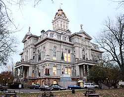
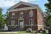
| 25 |
Licking County Courthouse |
|
01973-03-20-0000March 20, 1973
(#73001496) |
Courthouse Sq.
40°03′28″N 82°24′06″W / 40.057778°N 82.401667°W / 40.057778; -82.401667 (Licking County Courthouse) |
Newark |
|
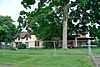
| 26 |
Lynnwood Farm |
Upload image |
01979-06-22-0000June 22, 1979
(#79001878) |
South of Johnstown at 4986 Caswell Rd.
40°07′40″N 82°40′22″W / 40.127778°N 82.672778°W / 40.127778; -82.672778 (Lynnwood Farm) |
Monroe Township |
|
| 27 |
McCune's Villa |
|
01982-04-22-0000April 22, 1982
(#82003602) |
537 Jones Rd., northeast of Granville
40°05′07″N 82°29′33″W / 40.085278°N 82.4925°W / 40.085278; -82.4925 (McCune's Villa) |
Granville Township |
|
| 28 |
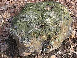
McDaniel Mound |
Upload image |
01974-05-02-0000May 2, 1974
(#74001545) |
Address Restricted
|
Washington Township |
Near Utica
|
| 29 |
McNamar-McLure-Miller Residence |
|
01982-06-17-0000June 17, 1982
(#82003603) |
124 W. Main St.
40°03′24″N 82°24′27″W / 40.056667°N 82.407500°W / 40.056667; -82.407500 (McNamar-McLure-Miller Residence) |
Newark |
|
| 30 |
Mead House |
|
01983-09-22-0000September 22, 1983
(#83001994) |
245 S. Main St.
39°59′54″N 82°40′33″W / 39.998333°N 82.675833°W / 39.998333; -82.675833 (Mead House) |
Pataskala |
|
| 31 |
Melick Mound |
Upload image |
01974-03-27-0000March 27, 1974
(#74001546) |
South of the North Fork of the Licking River, near Utica[8]
|
Washington Township |
|
| 32 |
Monroe Township Hall-Opera House |
|
01981-07-06-0000July 6, 1981
(#81000446) |
1 S. Main St.
40°09′14″N 82°41′04″W / 40.153806°N 82.684583°W / 40.153806; -82.684583 (Monroe Township Hall-Opera House) |
Johnstown |
|
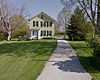
| 33 |
Newark Downtown Historic District |
|
02002-01-15-0000January 15, 2002
(#01001482) |
Roughly bounded by Church St., 2nd St., 5th St., and Canal St.
40°03′29″N 82°24′12″W / 40.058056°N 82.403333°W / 40.058056; -82.403333 (Newark Downtown Historic District) |
Newark |
|
| 34 |
Newark Earthworks |
|
01966-10-15-0000October 15, 1966
(#66000614) |
Roughly bounded by Union, 30th, James, and Waldo Sts., and State Route 16
40°03′07″N 82°26′55″W / 40.051944°N 82.448611°W / 40.051944; -82.448611 (Newark Earthworks) |
Heath and Newark |
|
| 35 |
Oakwood |
|
01980-05-29-0000May 29, 1980
(#80003141) |
64-70 Penney Ave.
40°03′41″N 82°23′03″W / 40.061389°N 82.384167°W / 40.061389; -82.384167 (Oakwood) |
Newark |
|
| 36 |
Ohio Canal Groundbreaking Site |
Upload image |
01973-05-24-0000May 24, 1973
(#73001493) |
State Route 79
40°00′46″N 82°27′27″W / 40.012778°N 82.4575°W / 40.012778; -82.4575 (Ohio Canal Groundbreaking Site) |
Heath |
|
| 37 |
Old Colony Burying Ground |
|
02005-06-10-0000June 10, 2005
(#05000577) |
250 S. Main St.
40°03′55″N 82°31′12″W / 40.065278°N 82.52°W / 40.065278; -82.52 (Old Colony Burying Ground) |
Granville |
|
| 38 |
Outville Depot |
|
01995-08-22-0000August 22, 1995
(#95001034) |
6750 Outville Rd., SW., east of Pataskala
39°59′41″N 82°35′49″W / 39.994722°N 82.596944°W / 39.994722; -82.596944 (Outville Depot) |
Harrison Township |
|
| 39 |
Pataskala Banking Company |
|
01983-09-22-0000September 22, 1983
(#83001996) |
354 S. Main St.
39°59′45″N 82°40′31″W / 39.995833°N 82.675278°W / 39.995833; -82.675278 (Pataskala Banking Company) |
Pataskala |
|
| 40 |
Pataskala Elementary School |
|
01983-09-22-0000September 22, 1983
(#83001995) |
396 S. High St.
40°00′00″N 82°40′42″W / 40.0°N 82.678333°W / 40.0; -82.678333 (Pataskala Elementary School) |
Pataskala |
|
| 41 |
Pataskala Jail |
|
01983-09-22-0000September 22, 1983
(#83001997) |
Main St.
39°59′56″N 82°40′31″W / 39.998889°N 82.675278°W / 39.998889; -82.675278 (Pataskala Jail) |
Pataskala |
|
| 42 |
Pataskala Presbyterian Church |
|
01983-11-14-0000November 14, 1983
(#83004323) |
Atkinson and Main Sts.
39°59′40″N 82°40′32″W / 39.994444°N 82.675556°W / 39.994444; -82.675556 (Pataskala Presbyterian Church) |
Pataskala |
|
| 43 |
Pataskala Town Hall |
|
01983-09-22-0000September 22, 1983
(#83001998) |
430 Main St.
39°59′38″N 82°40′30″W / 39.993889°N 82.675°W / 39.993889; -82.675 (Pataskala Town Hall) |
Pataskala |
|
| 44 |
Pataskala United Methodist Church |
|
01983-09-22-0000September 22, 1983
(#83001999) |
458 S. Main St.
39°59′36″N 82°40′30″W / 39.993333°N 82.675°W / 39.993333; -82.675 (Pataskala United Methodist Church) |
Pataskala |
|
| 45 |
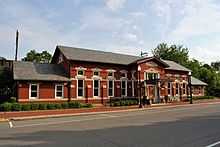
Pennsylvania Railway Station |
|
01979-11-29-0000November 29, 1979
(#79001881) |
25 E. Walnut St.
40°03′20″N 82°24′02″W / 40.055556°N 82.400556°W / 40.055556; -82.400556 (Pennsylvania Railway Station) |
Newark |
|
| 46 |
Anthony Pitzer, Jr., House |
|
01988-08-25-0000August 25, 1988
(#88001297) |
6019 White Chapel Rd., south of Newark
39°59′54″N 82°25′41″W / 39.998333°N 82.428056°W / 39.998333; -82.428056 (Anthony Pitzer, Jr., House) |
Licking Township |
|
| 47 |
Peter F. Rhoads House |
|
01980-11-28-0000November 28, 1980
(#80003142) |
74 Granville St.
40°03′38″N 82°24′34″W / 40.060556°N 82.409444°W / 40.060556; -82.409444 (Peter F. Rhoads House) |
Newark |
|
| 48 |
Rodrick Bridge |
|
01998-05-22-0000May 22, 1998
(#98000442) |
North of Granville Rd. between Hall Ave. and Village Dr. W
40°04′05″N 82°26′26″W / 40.068056°N 82.440556°W / 40.068056; -82.440556 (Rodrick Bridge) |
Newark |
Moved;[10] originally located southeast of Coshocton, Ohio[11]
|
| 49 |
Rogers House |
|
01980-11-28-0000November 28, 1980
(#80003139) |
304 N. Pearl St.
40°04′13″N 82°30′59″W / 40.070278°N 82.516389°W / 40.070278; -82.516389 (Rogers House) |
Granville |
|
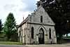
| 50 |
Capt. Levi Rose House |
|
01980-11-28-0000November 28, 1980
(#80003140) |
631 N. Pearl St.
40°03′59″N 82°31′15″W / 40.066389°N 82.520833°W / 40.066389; -82.520833 (Capt. Levi Rose House) |
Granville |
|
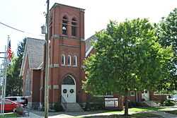
| 51 |
St. Luke's Episcopal Church |
|
01976-04-26-0000April 26, 1976
(#76001465) |
111 E. Broadway St.
40°04′03″N 82°31′11″W / 40.067500°N 82.519722°W / 40.067500; -82.519722 (St. Luke's Episcopal Church) |
Granville |
|
| 52 |
Martin Shaub Mill Site/House |
|
01985-01-23-0000January 23, 1985
(#85000119) |
8259 Duncan Plains Rd., northwest of Alexandria
40°06′25″N 82°38′53″W / 40.106944°N 82.648056°W / 40.106944; -82.648056 (Martin Shaub Mill Site/House) |
St. Albans Township |
|
| 53 |
Sherwood-Davidson and Buckingham Houses |
|
01977-11-10-0000November 10, 1977
(#77001072) |
W. Main and 6th Sts.
40°03′23″N 82°24′36″W / 40.056389°N 82.41°W / 40.056389; -82.41 (Sherwood-Davidson and Buckingham Houses) |
Newark |
|
| 54 |
Shield's Block |
|
01978-11-29-0000November 29, 1978
(#78002101) |
23-29 S. Park Pl.
40°03′26″N 82°24′03″W / 40.057222°N 82.400833°W / 40.057222; -82.400833 (Shield's Block) |
Newark |
|
| 55 |
Edwin Stanbery Office |
Upload image |
01978-11-30-0000November 30, 1978
(#78002100) |
1 mi (1.6 km) east of central Granville
40°04′03″N 82°30′31″W / 40.0675°N 82.508611°W / 40.0675; -82.508611 (Edwin Stanbery Office) |
Granville |
|
| 56 |
Upham-Wright House |
|
01979-06-22-0000June 22, 1979
(#79001882) |
342 Granville St.
40°03′49″N 82°25′10″W / 40.063611°N 82.419444°W / 40.063611; -82.419444 (Upham-Wright House) |
Newark |
|
| 57 |
Upland Farm |
Upload image |
01978-12-01-0000December 1, 1978
(#78002102) |
North of Newark off State Route 657
40°10′31″N 82°27′07″W / 40.175278°N 82.451944°W / 40.175278; -82.451944 (Upland Farm) |
Newton Township |
|
| 58 |
West Side Planing Mill (rear) |
Upload image |
01983-01-21-0000January 21, 1983
(#83002000) |
197 Maholm St.
40°03′03″N 82°25′40″W / 40.050833°N 82.427778°W / 40.050833; -82.427778 (West Side Planing Mill (rear)) |
Newark |
|
| 59 |
Elias Williams House |
|
01979-04-16-0000April 16, 1979
(#79001883) |
565 Granville St.
40°03′53″N 82°25′39″W / 40.064722°N 82.4275°W / 40.064722; -82.4275 (Elias Williams House) |
Newark |
|


.jpg)