National Register of Historic Places listings in Lewis and Clark County, Montana
Location of Lewis and Clark County in Montana
This is a list of the National Register of Historic Places listings in Lewis and Clark County, Montana.
This is intended to be a complete list of the properties and districts on the National Register of Historic Places in Lewis and Clark County, Montana, United States. The locations of National Register properties and districts for which the latitude and longitude coordinates are included below, may be seen in a Google map.[1]
There are 67 properties and districts listed on the National Register in the county.
- This National Park Service list is complete through NPS recent listings posted May 1, 2015.[2]
Current listings
| [3] | Name on the Register | Image | Date listed[4] | Location | City or town | Description |
|---|---|---|---|---|---|---|
| 1 | Algeria Shrine Temple | _-_Lewis_and_Clark_County%2C_Montana.png) |
(#88000434) |
Neill and Park Aves. 46°35′43″N 112°02′21″W / 46.595278°N 112.039167°W |
Helena | |
| 2 | Alice Creek Historic District |  |
(#06000531) |
Helena National Forest[5] 47°08′22″N 112°27′30″W / 47.139444°N 112.458333°W |
Lincoln | |
| 3 | Appleton House No. 9 | Upload image | (#95001264) |
1999 Euclid Ave. 46°36′20″N 112°03′52″W / 46.605556°N 112.064444°W |
Helena | |
| 4 | Appleton House No. 13 | Upload image | (#82000593) |
2200 Cannon 46°36′24″N 112°04′05″W / 46.606667°N 112.068056°W |
Helena | |
| 5 | Joshua and Martha Armitage House | Upload image | (#05000408) |
1117 E. Broadway 46°35′04″N 112°01′13″W / 46.584444°N 112.020278°W |
Helena | |
| 6 | Benton Avenue Cemetery | _-_Lewis_and_Clark_County%2C_Montana.png) |
(#03000689) |
1800 N. Benton Ave. 46°36′16″N 112°02′31″W / 46.604444°N 112.041944°W |
Helena | |
| 7 | Charles A. Broadwater House | Upload image | (#08000825) |
1104 Williams St. 46°36′21″N 112°05′19″W / 46.605703°N 112.088561°W |
Helena | |
| 8 | Cathedral of Saint Helena |  |
(#80004270) |
530 N. Ewing St. 46°35′25″N 112°01′57″W / 46.590278°N 112.0325°W |
Helena | |
| 9 | Childs Carriage House |  |
(#95001263) |
318 E. 6th Ave. 46°35′15″N 112°02′00″W / 46.5875°N 112.033333°W |
Helena | |
| 10 | William C. Crum House |  |
(#97000502) |
535 5th Ave. 46°35′09″N 112°01′50″W / 46.585833°N 112.030556°W |
Helena | |
| 11 | D.H. Cuthbert House | 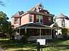 |
(#95000536) |
602 N. Ewing 46°35′28″N 112°01′53″W / 46.591111°N 112.031389°W |
Helena | |
| 12 | Dearborn River High Bridge |  |
(#03001298) |
15 miles (24 km) southwest of Augusta on Bean Lake Rd. 47°16′52″N 112°23′25″W / 47.281111°N 112.390278°W |
Augusta | |
| 13 | Donovan-Mayer House | Upload image | (#05001471) |
46 S. Howie St. 46°35′14″N 112°02′38″W / 46.587222°N 112.043889°W |
Helena | |
| 14 | Eagle's Site | Upload image | (#93000995) |
Address Restricted |
Helena | part of the Archeological Resources of the Upper Missouri River Corridor Multiple Property Submission (MPS) |
| 15 | Christmas Gift Evans House | Upload image | (#80004271) |
404 N. Benton Ave. 46°35′27″N 112°02′27″W / 46.590833°N 112.040833°W |
Helena | |
| 16 | Robert and Elizabeth Fisk House | 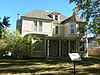 |
(#06001248) |
319 N. Rodney St. 46°35′15″N 112°01′56″W / 46.5875°N 112.032222°W |
Helena | |
| 17 | Forestvale Cemetery | Upload image | (#90000145) |
490 Forestvale Rd. 46°39′22″N 112°02′09″W / 46.656111°N 112.035833°W |
Helena | |
| 18 | Former Montana Executive Mansion | 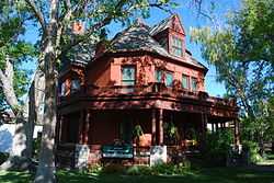 |
(#70000357) |
6th Ave. and Ewing St. 46°35′16″N 112°02′03″W / 46.587778°N 112.034167°W |
Helena | |
| 19 | Gilman State Bank | Upload image | (#83003993) |
Main St. 47°30′35″N 112°21′34″W / 47.509722°N 112.359444°W |
Gilman | |
| 20 | Gilpatrick-Root House | Upload image | (#05000883) |
604 Dearborn Ave. 46°35′35″N 112°02′32″W / 46.593056°N 112.042222°W |
Helena | |
| 21 | Haight-Bridgewater House | Upload image | (#14000080) |
502 Peosta Ave. 46°36′09″N 112°02′30″W / 46.602494°N 112.041593°W |
Helena | |
| 22 | Hauser Mansion | 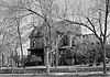 |
(#79001404) |
720 Madison Ave. 46°35′43″N 112°02′39″W / 46.595278°N 112.044167°W |
Helena | |
| 23 | Helena Historic District | 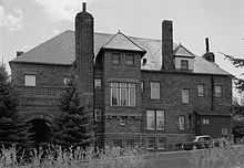 |
(#72000737) |
Irregular pattern from Hauser Boulevard to Acropolis and between Garfield and Rodney Sts.; also roughly bounded by Cruse, Neill and Park Aves., and Lawrence; also bounded by E. 6th, N. Davis, Broadway, and N. Rodney Sts. 46°34′34″N 112°02′26″W / 46.576111°N 112.040556°W |
Helena | Second and third sets of boundaries represent boundary increases of June 14, 1990 and October 7, 1993 |
| 24 | Helena Railroad Depot Historic District | 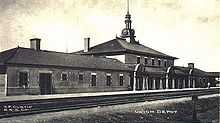 |
(#03001330) |
Roughly bounded by Railroad and Helena Aves., Gallatin St., N. Sanders St., and N. Harris St. 46°35′58″N 112°00′52″W / 46.599444°N 112.014444°W |
Helena | |
| 25 | Helena South-Central Historic District | Upload image | (#86002274) |
Roughly bounded by Broadway, S. Davis St., the city limits, and S. Warren St. 46°34′52″N 112°02′15″W / 46.581111°N 112.0375°W |
Helena | |
| 26 | Helena West Main Street Historic District | Upload image | (#96000119) |
500-600 blocks of W. Main St. 46°34′43″N 112°03′03″W / 46.578611°N 112.050833°W |
Helena | |
| 27 | Joe and Carrie Hilger Ranch | 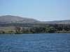 |
(#01000922) |
Sleeping Giant Ranch, 20 miles (32 km) north of Helena[6] 46°49′30″N 111°57′44″W / 46.825°N 111.962222°W |
Helena | |
| 28 | Home of Peace | 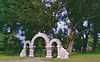 |
(#06000425) |
Alexander St. between Brady St. and Custer Ave. 46°36′53″N 112°03′01″W / 46.614722°N 112.050278°W |
Helena | |
| 29 | House of the Good Shepherd Historic District | _-_Lewis_and_Clark_County.png) |
(#93001448) |
Area surrounding the junction of 9th Ave. and N. Hoback St. 46°35′15″N 112°01′30″W / 46.5875°N 112.025°W |
Helena | |
| 30 | John H. Huseby House | 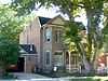 |
(#12001086) |
511 E. 6th Ave. 46°35′11″N 112°01′54″W / 46.586488°N 112.03157°W |
Helena | |
| 31 | Herman Kemna House | Upload image | (#92001056) |
635 1st St. 46°34′47″N 112°01′45″W / 46.579722°N 112.029167°W |
Helena | |
| 32 | T.H. Kleinschmidt House | _-_Lewis_and_Clark_County%2C_Montana.png) |
(#80004272) |
1823 Highland Ave. 46°34′58″N 112°00′25″W / 46.582778°N 112.006944°W |
Helena | |
| 33 | Kluge House | 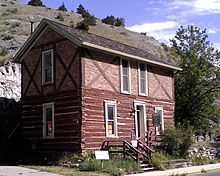 |
(#70000358) |
540 W. Main St. 46°35′22″N 111°55′47″W / 46.58948°N 111.9297°W |
Helena | |
| 34 | Lewis and Clark County Hospital Historic District | 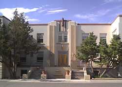 |
(#02001101) |
3404 Cooney Dr. 46°37′20″N 112°02′12″W / 46.622222°N 112.036667°W |
Helena | Old Cooney Home |
| 35 | Lincoln Community Hall | Upload image | (#86003674) |
Montana Highway 200 46°57′20″N 112°41′11″W / 46.955556°N 112.686389°W |
Lincoln | |
| 36 | Lincoln Lodge | Upload image | (#86002931) |
Stemple Pass Rd. 46°57′23″N 112°40′50″W / 46.956389°N 112.680556°W |
Lincoln | |
| 37 | Mann Gulch Wildfire Historic District | 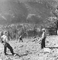 |
(#99000596) |
Mann Gulch, a tributary of the Missouri River 46°53′09″N 111°53′58″W / 46.885833°N 111.899444°W |
Helena | |
| 38 | Methodist-Episcopal Church of Marysville | Upload image | (#84002489) |
3rd St. 46°45′05″N 112°17′58″W / 46.751389°N 112.299444°W |
Marysville | |
| 39 | Missouri River Bridge | .jpg) |
(#09001181) |
Milepost 11 on Old U.S. Route 91 47°01′08″N 112°00′44″W / 47.018958°N 112.012114°W |
Wolf Creek | part of the Montana's Historic Steel Truss Bridges MPS |
| 40 | Montana State Arsenal, Armory and Drill Hall | _-_Lewis_and_Clark_County%2C_Montana.png) |
(#02000048) |
1100 N. Main 46°35′54″N 112°01′55″W / 46.598219°N 112.031864°W |
Helena | |
| 41 | Montana State Capitol Building |  |
(#81000660) |
Central Ave. and Main St. 46°35′09″N 112°01′12″W / 46.585833°N 112.02°W |
Helena | |
| 42 | Montana State Fairgrounds Racetrack | Upload image | (#06001136) |
98 W. Custer Ave. 46°37′17″N 112°03′22″W / 46.621389°N 112.056111°W |
Helena | |
| 43 | Montana Veterans and Pioneers Memorial Building | _-_Lewis_and_Clark_County%2C_Montana.png) |
(#04001357) |
225 N. Roberts 46°35′11″N 112°00′55″W / 46.586389°N 112.015278°W |
Helena | |
| 44 | Mount Helena Historic District | Upload image | (#96001568) |
Promontory roughly bounded by LeGrande Canon Boulevard, Last Chance and Grizzly Gulches, and the Helena National Forest boundary 46°35′15″N 112°03′28″W / 46.5875°N 112.057778°W |
Helena | |
| 45 | John T. Murphy House | Upload image | (#84002495) |
418 N. Benton Ave. 46°35′28″N 112°02′25″W / 46.591111°N 112.040278°W |
Helena | |
| 46 | Olsen House | _-_Lewis_and_Clark_County%2C_Montana.png) |
(#91000333) |
516 N. Park 46°35′33″N 112°02′23″W / 46.5925°N 112.039722°W |
Helena | |
| 47 | Francis and Hannah Pope House | 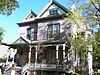 |
(#07000591) |
327 N. Rodney 46°35′16″N 112°01′55″W / 46.587778°N 112.031944°W |
Helena | |
| 48 | Porter Flats Apartments | _-_Lewis_and_Clark_County%2C_Montana.png) |
(#92001761) |
335 N. Ewing St. 46°35′15″N 112°02′02″W / 46.5875°N 112.033889°W |
Helena | |
| 49 | C.B. Power Bungalow | Upload image | (#95000380) |
1.2 miles (1.9 km) north of Interstate 15 and 1 mile (1.6 km) west of U.S. Route 287 47°02′48″N 112°03′52″W / 47.046667°N 112.064444°W |
Wolf Creek | |
| 50 | Thomas P. Regan Cabin | Upload image | (#02001686) |
McDonald Pass 46°34′42″N 112°18′12″W / 46.578333°N 112.303333°W |
Helena | |
| 51 | Sheep Creek Bridge | Upload image | (#11000225) |
Milepost 5 on Recreation Rd. 46°58′39″N 112°04′53″W / 46.9775°N 112.081389°W |
Wolf Creek vicinity | Reinforced Concrete Bridges in Montana, 1900-1958 MPS |
| 52 | Silver Creek School | Upload image | (#80004273) |
North of Helena on Sierra Rd. 46°39′37″N 112°00′27″W / 46.660278°N 112.0075°W |
Helena | |
| 53 | Silver King Ranch | Upload image | (#92000114) |
Roughly 15 miles (24 km) northeast of Lincoln in the Helena National Forest 47°04′26″N 112°33′30″W / 47.073889°N 112.558333°W |
Lincoln | |
| 54 | Morris Silverman House | 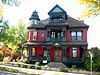 |
(#82004636) |
412 N. Rodney St. 46°35′20″N 112°01′52″W / 46.588889°N 112.031111°W |
Helena | |
| 55 | Spalding-Gunn House | Upload image | (#06001187) |
433 Clarke St. 46°35′29″N 112°02′41″W / 46.591389°N 112.044722°W |
Helena | |
| 56 | Stearns Hall | 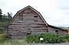 |
(#95000382) |
2 miles (3.2 km) north of the junction of Montana Highways 200 and 434 47°12′27″N 112°16′33″W / 47.2075°N 112.275833°W |
Wolf Creek | |
| 57 | Stedman Foundry and Machine Company | Upload image | (#96000370) |
2650 Euclid Ave. 46°36′32″N 112°04′30″W / 46.608889°N 112.075°W |
Helena | |
| 58 | Summit Lodge | Upload image | (#90000723) |
30 miles (48 km) northwest of Helena in the Helena National Forest 46°47′50″N 112°27′11″W / 46.797222°N 112.453056°W |
Helena | |
| 59 | Temple Emanu-El | 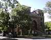 |
(#02000724) |
515 N. Ewing St. 46°35′24″N 112°01′54″W / 46.59°N 112.031667°W |
Helena | |
| 60 | Unemployment Compensation Commission Building | _-_Lewis_and_Clark_County%2C_MT.png) |
(#12000285) |
1315 -1327 Lockey Ave. 46°35′06″N 112°01′11″W / 46.584947°N 112.019758°W |
Helena | Now Department of Labor and Industry, Walt Sullivan Building |
| 61 | Wassweiler Hotel and Bath Houses | Upload image | (#78001688) |
West of Helena on U.S. Route 12 46°35′51″N 112°06′18″W / 46.5975°N 112.105°W |
Helena | |
| 62 | Western Clay Manufacturing Company | Upload image | (#85001052) |
2915 Country Club Rd. 46°36′53″N 112°04′53″W / 46.614722°N 112.081389°W |
Helena | |
| 63 | Western Life Insurance Company Helena Branch Office |  |
(#12000784) |
600 N. Park Ave. 46°35′38″N 112°02′27″W / 46.593751°N 112.040893°W |
Helena | |
| 64 | Wick-Seiler House | Upload image | (#00000873) |
729 11th Ave. 46°35′22″N 112°01′38″W / 46.589444°N 112.027222°W |
Helena | |
| 65 | Williams Street Bridge | Upload image | (#06001094) |
Williams St. crossing Ten Mile Creek, north of the junction of Williams St. and Broadwater Ave. 46°36′19″N 112°05′14″W / 46.605278°N 112.087222°W |
Helena | |
| 66 | Wolf Creek Hotel | Upload image | (#97001381) |
Junction of Main St. and Bissonmett St. 47°00′23″N 112°04′09″W / 47.006389°N 112.069167°W |
Wolf Creek | |
| 67 | Young Women's Christian Association (Independent) | _(2012)_-_Lewis_and_Clark_County%2C_Montana.png) |
(#84000569) |
501 N. Park St. 46°35′49″N 112°02′35″W / 46.596944°N 112.043056°W |
Helena |
See also
| Wikimedia Commons has media related to National Register of Historic Places in Lewis and Clark County, Montana. |
- List of National Historic Landmarks in Montana
- National Register of Historic Places listings in Montana
References
- ↑ The latitude and longitude information provided in this table was derived originally from the National Register Information System, which has been found to be fairly accurate for about 99% of listings. For about 1% of NRIS original coordinates, experience has shown that one or both coordinates are typos or otherwise extremely far off; some corrections may have been made. A more subtle problem causes many locations to be off by up to 150 yards, depending on location in the country: most NRIS coordinates were derived from tracing out latitude and longitudes off of USGS topographical quadrant maps created under the North American Datum of 1927, which differs from the current, highly accurate WGS84 GPS system used by most on-line maps. Chicago is about right, but NRIS longitudes in Washington are higher by about 4.5 seconds, and are lower by about 2.0 seconds in Maine. Latitudes differ by about 1.0 second in Florida. Some locations in this table may have been corrected to current GPS standards.
- ↑ "National Register of Historic Places: Weekly List Actions". National Park Service, United States Department of the Interior. Retrieved on May 1, 2015.
- ↑ Numbers represent an ordering by significant words. Various colorings, defined here, differentiate National Historic Landmarks and historic districts from other NRHP buildings, structures, sites or objects.
- ↑ The eight-digit number below each date is the number assigned to each location in the National Register Information System database, which can be viewed by clicking the number.
- ↑ Coordinates derived from the GNIS feature record for the Alice Creek Ranger Cabin
- ↑ Coordinates derived from its GNIS feature record
| ||||||||||||||||||||||||||
| |||||||||||||||||||||||||