| [3] |
Name on the Register[4] |
Image |
Date listed[5] |
Location |
City or town |
Description |
|---|
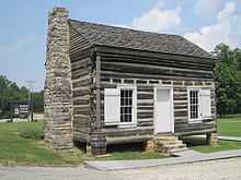
| 1 |
Bethel Cemetery |
Upload image |
02011-06-15-0000June 15, 2011
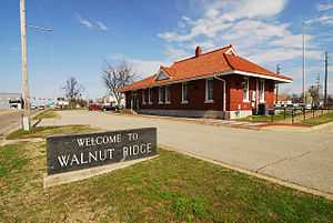
(#11000354) |
1.1 miles (1.8 km) north of AR 117 on County Rd. 225
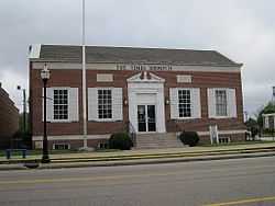
36°06′06″N 91°14′05″W / 36.101667°N 91.234722°W / 36.101667; -91.234722 (Bethel Cemetery) |
Denton vicinity |
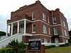
|
| 2 |
Dr. F.W. Buercklin House |
Upload image |
01998-07-24-0000July 24, 1998
(#98000882) |
104 Main St.
36°05′15″N 91°04′02″W / 36.0875°N 91.067222°W / 36.0875; -91.067222 (Dr. F.W. Buercklin House) |
Portia |
|
| 3 |
Building Number 29 |
Upload image |
02012-10-17-0000October 17, 2012
(#12000856) |
162 N. Beacon Rd.
36°07′41″N 90°55′42″W / 36.128135°N 90.928465°W / 36.128135; -90.928465 (Building Number 29) |
Walnut Ridge vicinity |
Part of the World War II Home Front Efforts in Arkansas, MPS
|
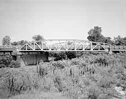
| 4 |
Cache River Bridge |
|
01990-04-09-0000April 9, 1990
(#90000523) |
Highway 25, over the Cache River
36°04′09″N 90°49′28″W / 36.069167°N 90.824444°W / 36.069167; -90.824444 (Cache River Bridge) |
Walnut Ridge |
|
| 5 |
Clover Bend High School |
Upload image |
01983-08-17-0000August 17, 1983
(#83001159) |
Highway 228
35°59′07″N 91°05′15″W / 35.985278°N 91.0875°W / 35.985278; -91.0875 (Clover Bend High School) |
Clover Bend |
|
| 6 |
Clover Bend Historic District |
Upload image |
01990-09-17-0000September 17, 1990
(#90001368) |
Junction of Highway 228 and County Road 1220
35°58′57″N 91°05′38″W / 35.9825°N 91.093889°W / 35.9825; -91.093889 (Clover Bend Historic District) |
Clover Bend |
|
| 7 |
Commandant's House |
Upload image |
02010-01-21-0000January 21, 2010
(#09001251) |
264 McClellan Dr.
36°07′47″N 90°56′21″W / 36.129722°N 90.939167°W / 36.129722; -90.939167 (Commandant's House) |
Walnut Ridge |
|
| 8 |
Ficklin-Imboden House |
|
01989-10-16-0000October 16, 1989
(#88003206) |
3rd and Main Sts.
36°04′55″N 91°07′00″W / 36.081944°N 91.116667°W / 36.081944; -91.116667 (Ficklin-Imboden House) |
Powhatan |
|
| 9 |
Dr. John Octavius Hatcher House |
Upload image |
01992-10-23-0000October 23, 1992
(#92001358) |
210 3rd St.
36°12′11″N 91°10′28″W / 36.203056°N 91.174444°W / 36.203056; -91.174444 (Dr. John Octavius Hatcher House) |
Imboden |
|
| 10 |
Home Economics-F.F.A. Building |
Upload image |
01990-06-14-0000June 14, 1990
(#90000901) |
City Park Dr.
36°05′06″N 91°04′11″W / 36.085°N 91.069722°W / 36.085; -91.069722 (Home Economics-F.F.A. Building) |
Portia |
|
| 11 |
Imboden Methodist Episcopal Church, South |
|
02004-06-30-0000June 30, 2004
(#04000505) |
113 Main St.
36°12′17″N 91°10′25″W / 36.204722°N 91.173611°W / 36.204722; -91.173611 (Imboden Methodist Episcopal Church, South) |
Imboden |
|
| 12 |
Missouri Pacific Depot-Walnut Ridge |
|
01992-06-11-0000June 11, 1992
(#92000622) |
SW. 1st St.
36°04′03″N 90°57′24″W / 36.0675°N 90.956667°W / 36.0675; -90.956667 (Missouri Pacific Depot-Walnut Ridge) |
Walnut Ridge |
|
| 13 |
Old US 67, Alicia to Hoxie |
Upload image |
02003-05-18-0000May 18, 2003
(#03000397) |
1st St., County Roads 747 and 549, and immediately east of the current U.S. Route 67
35°55′43″N 91°03′39″W / 35.928611°N 91.060833°W / 35.928611; -91.060833 (Old US 67, Alicia to Hoxie) |
Alicia |
|
| 14 |
Old Walnut Ridge Post Office |
|
01994-05-20-0000May 20, 1994
(#94000496) |
225 W. Main St.
36°04′10″N 90°57′27″W / 36.069444°N 90.9575°W / 36.069444; -90.9575 (Old Walnut Ridge Post Office) |
Walnut Ridge |
|
| 15 |
Portia School |
Upload image |
01978-12-13-0000December 13, 1978
(#78000604) |
City Park
36°05′05″N 91°04′15″W / 36.084722°N 91.070833°W / 36.084722; -91.070833 (Portia School) |
Portia |
|
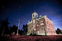
| 16 |
Powhatan Courthouse |
|
01970-02-16-0000February 16, 1970
(#70000122) |
Off Highway 25[6]
36°04′54″N 91°07′12″W / 36.081667°N 91.12°W / 36.081667; -91.12 (Powhatan Courthouse) |
Powhatan |
|
| 17 |
Powhatan Jail |
Upload image |
01989-10-16-0000October 16, 1989
(#88003205) |
Highway 25
36°04′56″N 91°07′06″W / 36.082222°N 91.118333°W / 36.082222; -91.118333 (Powhatan Jail) |
Powhatan |
|
| 18 |
Powhatan Methodist Church |
Upload image |
01977-11-23-0000November 23, 1977
(#77000260) |
Highway 25
36°04′55″N 91°07′12″W / 36.081944°N 91.12°W / 36.081944; -91.12 (Powhatan Methodist Church) |
Powhatan |
|
| 19 |
Powhatan Schoolhouse |
Upload image |
01978-07-31-0000July 31, 1978
(#78000605) |
Highway 25
36°04′55″N 91°07′15″W / 36.081944°N 91.120833°W / 36.081944; -91.120833 (Powhatan Schoolhouse) |
Powhatan |
|
| 20 |
St. Louis-San Francisco Overpass |
|
01990-04-09-0000April 9, 1990
(#90000513) |
U.S. Route 62 over the Spring River
36°12′24″N 91°10′17″W / 36.206667°N 91.171389°W / 36.206667; -91.171389 (St. Louis-San Francisco Overpass) |
Imboden |
|
| 21 |
Smithville Public School Building |
Upload image |
01993-01-14-0000January 14, 1993
(#92001219) |
Highway 117
36°04′48″N 91°18′20″W / 36.08°N 91.305556°W / 36.08; -91.305556 (Smithville Public School Building) |
Smithville |
|
| 22 |
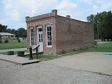
Telephone Exchange Building |
|
01989-10-16-0000October 16, 1989
(#88003207) |
1st and Main Sts.
36°04′54″N 91°06′58″W / 36.081667°N 91.116111°W / 36.081667; -91.116111 (Telephone Exchange Building) |
Powhatan |
|
| 23 |
US 63 Black River Bridge |
Upload image |
02000-06-09-0000June 9, 2000
(#00000631) |
U.S. Route 63
36°05′52″N 91°05′32″W / 36.097778°N 91.092222°W / 36.097778; -91.092222 (US 63 Black River Bridge) |
Black Rock |
|
| 24 |
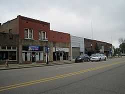
Walnut Ridge Commercial Historic District |
|
02010-05-28-0000May 28, 2010
(#10000286) |
Roughly bounded by East and West Main, North and South Front Sts, West Vine, and Southwest Third Sts
36°04′06″N 90°57′21″W / 36.068419°N 90.955953°W / 36.068419; -90.955953 (Walnut Ridge Commercial Historic District) |
Walnut Ridge |
|
.jpg)