National Register of Historic Places listings in Lauderdale County, Alabama
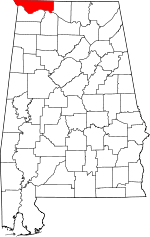
Location of Lauderdale County in Alabama
This is a list of the National Register of Historic Places listings in Lauderdale County, Alabama.
This is intended to be a complete list of the properties and districts on the National Register of Historic Places in Lauderdale County, Alabama, United States. Latitude and longitude coordinates are provided for many National Register properties and districts; these locations may be seen together in a Google map.[1]
There are 31 properties and districts listed on the National Register in the county, including 1 National Historic Landmark.
- This National Park Service list is complete through NPS recent listings posted May 1, 2015.[2]
Current listings
| [3] | Name on the Register | Image | Date listed[4] | Location | City or town | Description |
|---|---|---|---|---|---|---|
| 1 | Peter F. Armistead, Sr., House | Upload image | (#86001540) |
Waterloo Rd. Coordinates missing |
Florence | |
| 2 | William Bowen Lustron House | Upload image | (#00000135) |
1145 Wildwood Park Rd. 34°49′00″N 87°41′18″W / 34.816728°N 87.688226°W |
Florence | |
| 3 | Cherry Street Historic District | Upload image | (#97000648) |
Cherry St. between Hermitage Dr. and E. Tombigbee St. 34°48′29″N 87°40′21″W / 34.808056°N 87.672500°W |
Florence | |
| 4 | Coffee High School | Upload image | (#82002045) |
319 Hermitage Dr. 34°48′28″N 87°40′32″W / 34.807778°N 87.675556°W |
Florence | |
| 5 | College Place Historic District | Upload image | (#94001547) |
Along Sherrod Ave. between W. Lelia St. and Circular Rd.; also roughly along W. Lelia and W. Mattie Lou Sts. 34°48′46″N 87°40′51″W / 34.812778°N 87.680833°W |
Florence | Second set of boundaries represents a boundary increase of September 14, 1998 |
| 6 | George Coulter House | .jpg) |
(#82002046) |
420 S. Pine St. 34°47′45″N 87°40′31″W / 34.795833°N 87.675278°W |
Florence | |
| 7 | Courtview | .jpg) |
(#74000415) |
Court St. 34°48′21″N 87°40′46″W / 34.805833°N 87.679444°W |
Florence | |
| 8 | E.H. Darby Lustron House | Upload image | (#00000127) |
321 Beverly 34°47′30″N 87°41′19″W / 34.791750°N 87.688611°W |
Florence | |
| 9 | Downtown Florence Historic District | 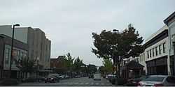 |
(#95001021) |
Roughly the eastern side of Court St. from 104 N. Court to 119 S. Court, 100-128 E. Tennessee St., and 106, 108, and 110 S. Seminary St.; also roughly bounded by Pine St., Alabama St., Wood Ave., and Tuscaloosa St. 34°48′00″N 87°40′31″W / 34.8°N 87.675278°W |
Florence | Second set of boundaries represents a boundary increase of December 18, 2001 |
| 10 | Florence Wagon Works Site | Upload image | (#96000596) |
South of Dekalb Ave. between Main and Spurr Sts. 34°48′09″N 87°38′35″W / 34.802500°N 87.643056°W |
Florence | |
| 11 | Forks of Cypress |  |
(#97001166) |
Jackson Rd., roughly 1.5 miles northwest of the junction of Cox Creek Parkway and Jackson Rd. Coordinates missing |
Florence | |
| 12 | Forks of Cypress Cemetery | .jpg) |
(#00000140) |
0.25 miles north of Jackson Rd. on the eastern side of Dowdy Rd., north of Little Cypress Creek 34°50′53″N 87°43′19″W / 34.848056°N 87.721944°W |
Florence | |
| 13 | Karsner-Carroll House | 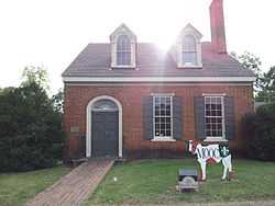 |
(#70000104) |
303 N. Pine St. 34°48′05″N 87°40′43″W / 34.801500°N 87.678611°W |
Florence | |
| 14 | William Koger House | Upload image | (#86001542) |
Smithsonia-Rhodesville Rd. Coordinates missing |
Smithsonia | |
| 15 | Larimore House | Upload image | (#74000416) |
Mars Hill Rd./U.S. Route 8, Box 344 34°50′48″N 87°39′36″W / 34.846667°N 87.66°W |
Florence | |
| 16 | Locust Street Historic District | 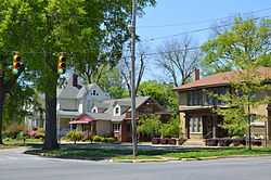 |
(#02001065) |
Roughly bounded by Pine St., College St., Locust St., and Irvine Ave. 34°48′08″N 87°40′47″W / 34.802222°N 87.679722°W |
Florence | |
| 17 | James Martin House | 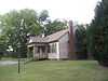 |
(#81000128) |
1400 Cypress Mill Rd. 34°48′57″N 87°42′12″W / 34.815833°N 87.703333°W |
Florence | |
| 18 | Old Natchez Trace (310-2A) | 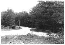 |
(#76000156) |
15 miles northwest of Florence on State Route 20 34°55′31″N 87°50′38″W / 34.925278°N 87.843889°W |
Florence | 1,250-foot segment of the Natchez Trace, both paved and unpaved.[5] |
| 19 | Gov. Robert Patton House | .jpg) |
(#76000335) |
Sweetwater and Florence Boulevard 34°49′28″N 87°38′34″W / 34.824444°N 87.642778°W |
Florence | |
| 20 | Rogers Department Store | 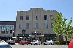 |
(#98001025) |
117 N. Court St. 34°48′03″N 87°40′36″W / 34.800833°N 87.676667°W |
Florence | |
| 21 | Rosenbaum House | 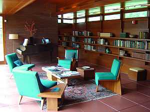 |
(#78000492) |
601 Riverview Dr. 34°47′34″N 87°40′49″W / 34.792778°N 87.680278°W |
Florence | |
| 22 | Sannoner Historic District | 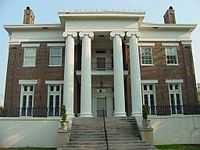 |
(#76000336) |
Includes both sides of N. Pine and N. Court from Tuscaloosa Ave. to the University of North Alabama campus 34°48′14″N 87°40′45″W / 34.803849°N 87.679095°W |
Florence | |
| 23 | Seminary-O'Neal Historic District | Upload image | (#95000092) |
Roughly Seminary St. between Hermitage Dr. and Irvine Ave. and Irvine between Seminary and Wood Ave. 34°48′20″N 87°40′39″W / 34.805556°N 87.677500°W |
Florence | |
| 24 | Seven Mile Island Archeological District | Upload image | (#79003352) |
Address Restricted[6] 34°45′02″N 87°44′12″W / 34.7506°N 87.7367°W |
Florence | |
| 25 | Southall Drugs | 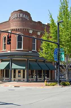 |
(#80000699) |
201 N. Court St. 34°48′04″N 87°40′37″W / 34.801111°N 87.676806°W |
Florence | |
| 26 | Walnut Street Historic District | 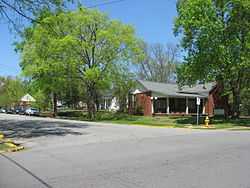 |
(#76000337) |
N. Walnut between Hermitage and Tuscaloosa; also 415-609 N. Poplar St. (odd numbers only); also the junction of Poplar and Tuscaloosa Sts. 34°48′20″N 87°40′28″W / 34.805556°N 87.674444°W |
Florence | Second and third sets of boundaries represent boundary increases of April 4, 1993 and March 16, 1996 respectively |
| 27 | Water Tower | 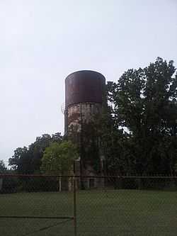 |
(#80000700) |
Seymore St. 34°49′29″N 87°41′27″W / 34.824722°N 87.690833°W |
Florence | |
| 28 | Wesleyan Hall | 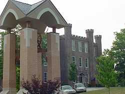 |
(#74000417) |
Morrison Ave. 34°48′32″N 87°40′47″W / 34.808889°N 87.679722°W |
Florence | |
| 29 | Wilson Dam |  |
(#66000147) |
On the Tennessee River along State Route 133 34°48′03″N 87°37′33″W / 34.800917°N 87.625817°W |
Florence | Extends into Colbert County |
| 30 | Wilson Park Houses | 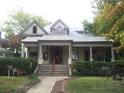 |
(#79000390) |
209, 217, and 223 E. Tuscaloosa St. 34°48′14″N 87°40′31″W / 34.803889°N 87.675278°W |
Florence | |
| 31 | Wood Avenue Historic District | 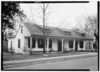 |
(#78000493) |
N. Wood Ave. roughly bounded by Tuscaloosa and Hawthorne Sts.; also roughly along E. Hawthorne, Meridian and Kendrick Sts.; also roughly along Kendrick Ave. and 633 Hermitage Dr. 34°48′26″N 87°40′37″W / 34.807222°N 87.676944°W |
Florence | Second and third sets of boundaries represent boundary increases of March 16, 1996 and August 3, 1997 respectively |
See also
| Wikimedia Commons has media related to National Register of Historic Places in Lauderdale County, Alabama. |
- List of National Historic Landmarks in Alabama
- National Register of Historic Places listings in Alabama
References
- ↑ The latitude and longitude information provided in this table was derived originally from the National Register Information System, which has been found to be fairly accurate for about 99% of listings. For about 1% of NRIS original coordinates, experience has shown that one or both coordinates are typos or otherwise extremely far off; some corrections may have been made. A more subtle problem causes many locations to be off by up to 150 yards, depending on location in the country: most NRIS coordinates were derived from tracing out latitude and longitudes off of USGS topographical quadrant maps created under the North American Datum of 1927, which differs from the current, highly accurate WGS84 GPS system used by most on-line maps. Chicago is about right, but NRIS longitudes in Washington are higher by about 4.5 seconds, and are lower by about 2.0 seconds in Maine. Latitudes differ by about 1.0 second in Florida. Some locations in this table may have been corrected to current GPS standards.
- ↑ "National Register of Historic Places: Weekly List Actions". National Park Service, United States Department of the Interior. Retrieved on May 1, 2015.
- ↑ Numbers represent an ordering by significant words. Various colorings, defined here, differentiate National Historic Landmarks and historic districts from other NRHP buildings, structures, sites or objects.
- ↑ The eight-digit number below each date is the number assigned to each location in the National Register Information System database, which can be viewed by clicking the number.
- ↑ William E. Cox (October 1, 1974). "National Register of Historic Places Inventory-Nomination: Old Natchez Trace (No. 310-2A) / Road from Natchez to Nashville, Path to Chickasaw Nation, Path to Choctaw Nation, Natchez Trace" (PDF). National Park Service. and Accompanying photo from 1976, and map
- ↑ Coordinates are derived from the GNIS feature record for Sevenmile Island closest to Florence; the NRIS provides no coordinates
| |||||||||||||||||||||


| |||||||||||||||||||||||||