National Register of Historic Places listings in Lafayette County, Arkansas
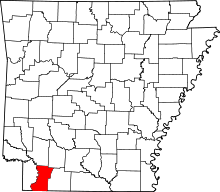
Location of Lafayette County in Arkansas
This is a list of the National Register of Historic Places listings in Lafayette County, Arkansas.
This is intended to be a complete list of the properties on the National Register of Historic Places in Lafayette County, Arkansas, United States. The locations of National Register properties for which the latitude and longitude coordinates are included below, may be seen in a Google map.[1]
There are 9 properties listed on the National Register in the county.
Contents: Counties in Arkansas
|
|
- This National Park Service list is complete through NPS recent listings posted May 1, 2015.[2]
Current listings
| [3] |
Name on the Register[4] |
Image |
Date listed[5] |
Location |
City or town |
Description |
|---|
| 1 |
P.D. Burton House |
Upload image |
01998-06-03-0000June 3, 1998
(#98000612) |
305 Chestnut
33°21′29″N 93°34′44″W / 33.358056°N 93.578889°W / 33.358056; -93.578889 (P.D. Burton House) |
Lewisville |
|
| 2 |
Conway Cemetery |
Upload image |
01977-11-23-0000November 23, 1977
(#77000259) |
West of Bradley
33°06′11″N 93°41′02″W / 33.103056°N 93.683889°W / 33.103056; -93.683889 (Conway Cemetery) |
Bradley |
|
| 3 |
First Methodist Church |
Upload image |
01996-06-20-0000June 20, 1996
(#96000639) |
Northwestern corner of the junction of Chestnut and 4th Sts.
33°21′30″N 93°34′44″W / 33.358333°N 93.578889°W / 33.358333; -93.578889 (First Methodist Church) |
Lewisville |
|
| 4 |
First Presbyterian Church |
Upload image |
01996-06-20-0000June 20, 1996
(#96000640) |
Southwestern corner of the junction of Market and Church Sts.
33°21′42″N 93°29′40″W / 33.361667°N 93.494444°W / 33.361667; -93.494444 (First Presbyterian Church) |
Stamps |
|
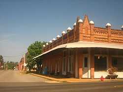
| 5 |
King-Whatley Building |
|
01978-03-30-0000March 30, 1978
(#78000603) |
2nd and Maple Sts.
33°21′23″N 93°34′38″W / 33.356389°N 93.577222°W / 33.356389; -93.577222 (King-Whatley Building) |
Lewisville |
|
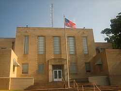
| 6 |
Lafayette County Courthouse |
|
01993-02-25-0000February 25, 1993
(#93000085) |
Bounded by 3rd, Spruce, 4th, and Maple Sts.
33°21′26″N 93°34′36″W / 33.357222°N 93.576667°W / 33.357222; -93.576667 (Lafayette County Courthouse) |
Lewisville |
|
| 7 |
Lafayette County Training School |
Upload image |
02005-01-20-0000January 20, 2005
(#04001500) |
1046 Berry St.
33°21′11″N 93°29′17″W / 33.353056°N 93.488056°W / 33.353056; -93.488056 (Lafayette County Training School) |
Stamps |
|
| 8 |
Peoples Bank and Loan Building |
Upload image |
01996-06-20-0000June 20, 1996
(#96000637) |
Southwestern corner of the junction of Spruce and 3rd Sts.
33°21′24″N 93°34′39″W / 33.356667°N 93.5775°W / 33.356667; -93.5775 (Peoples Bank and Loan Building) |
Lewisville |
|
| 9 |
Triplett Company Building |
Upload image |
01996-06-20-0000June 20, 1996
(#96000638) |
2nd St., west of its junction with Spruce St.
33°21′23″N 93°34′48″W / 33.356389°N 93.58°W / 33.356389; -93.58 (Triplett Company Building) |
Lewisville |
|
See also
References
- ↑ The latitude and longitude information provided in this table was derived originally from the National Register Information System, which has been found to be fairly accurate for about 99% of listings. For about 1% of NRIS original coordinates, experience has shown that one or both coordinates are typos or otherwise extremely far off; some corrections may have been made. A more subtle problem causes many locations to be off by up to 150 yards, depending on location in the country: most NRIS coordinates were derived from tracing out latitude and longitudes off of USGS topographical quadrant maps created under the North American Datum of 1927, which differs from the current, highly accurate WGS84 GPS system used by most on-line maps. Chicago is about right, but NRIS longitudes in Washington are higher by about 4.5 seconds, and are lower by about 2.0 seconds in Maine. Latitudes differ by about 1.0 second in Florida. Some locations in this table may have been corrected to current GPS standards.
- ↑ "National Register of Historic Places: Weekly List Actions". National Park Service, United States Department of the Interior. Retrieved on May 1, 2015.
- ↑ Numbers represent an ordering by significant words. Various colorings, defined here, differentiate National Historic Landmarks and historic districts from other NRHP buildings, structures, sites or objects.
- ↑ "National Register Information System". National Register of Historic Places. National Park Service. 2009-03-13.
- ↑ The eight-digit number below each date is the number assigned to each location in the National Register Information System database, which can be viewed by clicking the number.
|
|---|
| | Topics | |
|---|
| | Lists by states | |
|---|
| | Lists by insular areas | |
|---|
| | Lists by associated states | |
|---|
| | Other areas | |
|---|
|
-
 Category Category
-
 Portal Portal
-
 WikiProject WikiProject
|
|