National Register of Historic Places listings in Kendall County, Illinois

Location of Kendall County in Illinois
This is a list of the National Register of Historic Places listings in Kendall County, Illinois.
This is intended to be a complete list of the properties and districts on the National Register of Historic Places in Kendall County, Illinois, United States. Latitude and longitude coordinates are provided for many National Register properties and districts; these locations may be seen together in a Google map.[1]
There are 9 properties and districts listed on the National Register in the county.
- This National Park Service list is complete through NPS recent listings posted May 1, 2015.[2]
Current listings
| [3] |
Name on the Register |
Image |
Date listed[4] |
Location |
City or town |
Description |
|---|
| 1 |
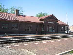
Chicago, Burlington & Quincy Railroad Depot |
|
01993-11-12-0000November 12, 1993
(#93001238) |
101 W. Main St.
41°39′44″N 88°32′17″W / 41.662222°N 88.538056°W / 41.662222; -88.538056 (Chicago, Burlington & Quincy Railroad Depot) |
Plano |
|
| 2 |
Evelyn Site |
Upload image |
01978-12-19-0000December 19, 1978
(#78001159) |
Midway between Newark and Lisbon Center Rds., east of Big Grove Rd.[5]
41°31′49″N 88°30′26″W / 41.53027°N 88.50722°W / 41.53027; -88.50722 (Evelyn Site) |
Newark |
|
| 3 |
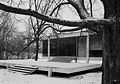
Farnsworth House |
|
02004-10-07-0000October 7, 2004
(#04000867) |
14520 River Rd.
41°38′15″N 88°32′07″W / 41.6375°N 88.535278°W / 41.6375; -88.535278 (Farnsworth House) |
Plano |
|
| 4 |
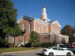
Kendall County Courthouse |
|
01998-11-12-0000November 12, 1998
(#98001354) |
109 W. Ridge St.
41°38′25″N 88°26′53″W / 41.640278°N 88.448056°W / 41.640278; -88.448056 (Kendall County Courthouse) |
Yorkville |
|
| 5 |
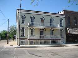
Plano Hotel |
|
01993-11-12-0000November 12, 1993
(#93001239) |
120 W. Main St.
41°39′44″N 88°32′21″W / 41.662222°N 88.539167°W / 41.662222; -88.539167 (Plano Hotel) |
Plano |
|
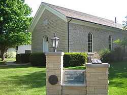
| 6 |
Reorganized Church of Jesus Christ of Latter Day Saints |
|
01990-11-02-0000November 2, 1990
(#90001724) |
304 S. Center Ave.
41°39′33″N 88°32′09″W / 41.659167°N 88.535833°W / 41.659167; -88.535833 (Reorganized Church of Jesus Christ of Latter Day Saints) |
Plano |
|
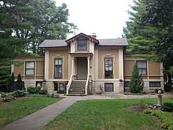
| 7 |
Albert H. Sears House |
|
01987-01-29-0000January 29, 1987
(#86003720) |
603 E. North St.
41°39′55″N 88°31′49″W / 41.665278°N 88.530278°W / 41.665278; -88.530278 (Albert H. Sears House) |
Plano |
|
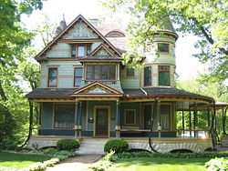
| 8 |
Lewis Steward House |
|
02003-11-28-0000November 28, 2003
(#03001200) |
611 E. Main St.
41°39′54″N 88°31′47″W / 41.665°N 88.529722°W / 41.665; -88.529722 (Lewis Steward House) |
Plano |
|
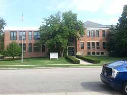
| 9 |
Yorkville School |
|
01995-01-24-0000January 24, 1995
(#94001600) |
201 W. Center St.
41°38′52″N 88°26′53″W / 41.647778°N 88.448056°W / 41.647778; -88.448056 (Yorkville School) |
Yorkville |
|
See also
References
- ↑ The latitude and longitude information provided in this table was derived originally from the National Register Information System, which has been found to be fairly accurate for about 99% of listings. For about 1% of NRIS original coordinates, experience has shown that one or both coordinates are typos or otherwise extremely far off; some corrections may have been made. A more subtle problem causes many locations to be off by up to 150 yards, depending on location in the country: most NRIS coordinates were derived from tracing out latitude and longitudes off of USGS topographical quadrant maps created under the North American Datum of 1927, which differs from the current, highly accurate WGS84 GPS system used by most on-line maps. Chicago is about right, but NRIS longitudes in Washington are higher by about 4.5 seconds, and are lower by about 2.0 seconds in Maine. Latitudes differ by about 1.0 second in Florida. Some locations in this table may have been corrected to current GPS standards.
- ↑ "National Register of Historic Places: Weekly List Actions". National Park Service, United States Department of the Interior. Retrieved on May 1, 2015.
- ↑ Numbers represent an ordering by significant words. Various colorings, defined here, differentiate National Historic Landmarks and historic districts from other NRHP buildings, structures, sites or objects.
- ↑ The eight-digit number below each date is the number assigned to each location in the National Register Information System database, which can be viewed by clicking the number.
- ↑ Maruszak, Kathleen. National Register of Historic Places Inventory/Nomination: Evelyn Site. National Park Service, 1978-04, 7.
|
|---|
| | Topics | |
|---|
| | Lists by states | |
|---|
| | Lists by insular areas | |
|---|
| | Lists by associated states | |
|---|
| | Other areas | |
|---|
|
-
 Category Category
-
 Portal Portal
-
 WikiProject WikiProject
|
|