National Register of Historic Places listings in Kay County, Oklahoma
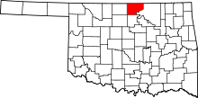
Location of Kay County in Oklahoma
This is a list of the National Register of Historic Places listings in Kay County, Oklahoma.
This is intended to be a complete list of the properties and districts on the National Register of Historic Places in Kay County, Oklahoma, United States. The locations of National Register properties and districts for which the latitude and longitude coordinates are included below, may be seen in a Google map.[1]
There are 40 properties and districts listed on the National Register in the county, including 3 National Historic Landmarks.
- This National Park Service list is complete through NPS recent listings posted May 1, 2015.[2]
| Adair - Alfalfa - Atoka - Beaver - Beckham - Blaine - Bryan - Caddo - Canadian - Carter - Cherokee - Choctaw - Cimarron - Cleveland - Coal - Comanche - Cotton - Craig - Creek - Custer - Delaware - Dewey - Ellis - Garfield - Garvin - Grady - Grant - Greer - Harmon - Harper - Haskell - Hughes - Jackson - Jefferson - Johnston - Kay - Kingfisher - Kiowa - Latimer - Le Flore - Lincoln - Logan - Love - Major - Marshall - Mayes - McClain - McCurtain - McIntosh - Murray - Muskogee - Noble - Nowata - Okfuskee - Oklahoma - Okmulgee - Osage - Ottawa - Pawnee - Payne - Pittsburg - Pontotoc - Pottawatomie - Pushmataha - Roger Mills - Rogers - Seminole - Sequoyah - Stephens - Texas - Tillman - Tulsa - Wagoner - Washington - Washita - Woods - Woodward |
Current listings
| [3] | Name on the Register[4] | Image | Date listed[5] | Location | City or town | Description |
|---|---|---|---|---|---|---|
| 1 | Bennie L. Aupperle Dairy Barn | Upload image | (#12001038) |
8700 N. La Cann Rd. 36°55′17″N 97°01′49″W / 36.92136°N 97.0303°W |
Newkirk | |
| 2 | Big V Ranch House | Upload image | (#84003068) |
Off State Highway 156 36°37′09″N 97°10′31″W / 36.619167°N 97.175278°W |
Ponca City | |
| 3 | Blackwell Armory | |
(#88001366) |
6th and Doolin Sts. 36°48′40″N 97°17′28″W / 36.811111°N 97.291111°W |
Blackwell | |
| 4 | Blaine Stadium and Fieldhouse | |
(#88001364) |
5th and Brookfield Sts. 36°43′06″N 97°04′38″W / 36.718333°N 97.077222°W |
Ponca City | |
| 5 | Bryson Archeological Site | Upload image | (#79001997) |
Address Restricted |
Newkirk | |
| 6 | Chilocco Indian Agricultural School | 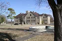 |
(#06000792) |
U.S. Route 77 and E0018 Rd. 36°59′06″N 97°03′45″W / 36.985°N 97.0625°W |
Newkirk | |
| 7 | Darr School of Aeronautics Hangar No. 3 | |
(#06000794) |
Southwest of the junction of Darr Park Dr. and Lindsey Rd. 36°44′10″N 97°05′50″W / 36.736111°N 97.097222°W |
Ponca City | |
| 8 | Deer Creek Site | Upload image | (#66000630) |
Address Restricted |
Newkirk | |
| 9 | Daniel J. Donahoe House | 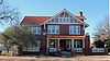 |
(#82003686) |
302 S. 7th St. 36°42′04″N 97°04′33″W / 36.701111°N 97.075833°W |
Ponca City | |
| 10 | Downtown Ponca City Historic District | 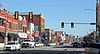 |
(#10001010) |
Roughly bounded by Pine St., Chestnut St., 7th St., and Central Ave. 36°42′15″N 97°04′52″W / 36.704167°N 97.081111°W |
Ponca City | |
| 11 | Electric Park Pavilion | |
(#76001563) |
300 S. Main 36°48′06″N 97°16′54″W / 36.801667°N 97.281667°W |
Blackwell | |
| 12 | First Church of Christ, Scientist | Upload image | (#15000063) |
300 N. 3rd St. 36°42′21″N 97°04′52″W / 36.7059°N 97.0811°W |
Ponca City | |
| 13 | First Presbyterian Church of Tonkawa | 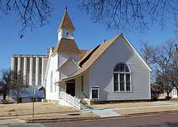 |
(#94001081) |
109 S. 4th St. 36°40′43″N 97°18′18″W / 36.678611°N 97.305°W |
Tonkawa | |
| 14 | Huston Elementary School | |
(#09000073) |
304 Vinnedge Ave. 36°47′11″N 97°17′12″W / 36.786389°N 97.286667°W |
Blackwell | |
| 15 | Gov. William W. Jenkins Homestead Site | Upload image | (#76001564) |
Address Restricted |
Newkirk | |
| 16 | Kaw City Depot | Upload image | (#79001996) |
West of Kaw City on Washungah Dr. 36°45′53″N 96°51′29″W / 36.764722°N 96.858056°W |
Kaw City | |
| 17 | Kaw Indian Agency | Upload image | (#73001562) |
North of the Arkansas River 36°46′36″N 96°50′00″W / 36.776667°N 96.833333°W |
Washunga | |
| 18 | Kay County Courthouse | 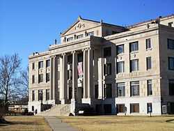 |
(#84003070) |
Courthouse Square 36°52′51″N 97°03′14″W / 36.880833°N 97.053889°W |
Newkirk | |
| 19 | Larkin Hotel | Upload image | (#13000940) |
201 N. Main St. 36°48′20″N 97°17′00″W / 36.805461°N 97.283396°W |
Blackwell | |
| 20 | Mahoney House and Garage | 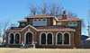 |
(#84003074) |
302 N. Main Ave. 36°40′53″N 97°18′33″W / 36.681389°N 97.309167°W |
Tonkawa | |
| 21 | E. W. Marland Mansion | 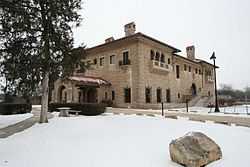 |
(#73001561) |
Monument Rd. 36°43′00″N 97°03′37″W / 36.716667°N 97.060278°W |
Ponca City | |
| 22 | Marland-Paris House | 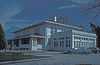 |
(#76001565) |
1000 E. Grand 36°42′11″N 97°04′17″W / 36.703056°N 97.071389°W |
Ponca City | |
| 23 | Newkirk Central Business District | 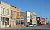 |
(#84003079) |
Main and 7th Sts. 36°54′01″N 97°03′10″W / 36.900278°N 97.052778°W |
Newkirk | |
| 24 | Newkirk Water Purification Plant | 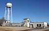 |
(#88001365) |
10th and Elm Sts. 36°52′44″N 97°03′04″W / 36.878889°N 97.051111°W |
Newkirk | |
| 25 | Nez Perce Reservation | Upload image | (#74001663) |
Address Restricted |
Tonkawa | |
| 26 | Northside Elementary School | Upload image | (#09000074) |
720 W. Doolin Ave. 36°48′41″N 97°17′33″W / 36.811389°N 97.2925°W |
Blackwell | |
| 27 | One-hundred-and-one Ranch | 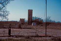 |
(#73001560) |
12 miles southwest of Ponca City on State Highway 156 36°36′47″N 97°08′34″W / 36.613056°N 97.142778°W |
Ponca City | |
| 28 | Parkside Elementary School | 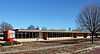 |
(#09000075) |
502 E. College Ave. 36°48′05″N 97°16′36″W / 36.801389°N 97.276667°W |
Blackwell | |
| 29 | Pioneer Woman Statue |  |
(#78002238) |
Monument Circle 36°42′36″N 97°03′55″W / 36.71°N 97.065278°W |
Ponca City | |
| 30 | Poncan Theatre | 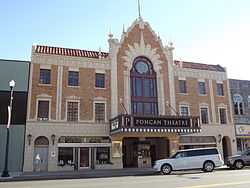 |
(#84000455) |
104 E. Grand Ave. 36°42′11″N 97°04′58″W / 36.703056°N 97.082778°W |
Ponca City | |
| 31 | St. John Baptist Church and Rectory | Upload image | (#15000064) |
1009 S. 11th St. 36°41′35″N 97°04′16″W / 36.6930°N 97.0711°W |
Ponca City | |
| 32 | Santa Fe Depot | |
(#12000113) |
Near junction of S. 1st & W. Oklahoma 36°42′06″N 97°05′02″W / 36.701587°N 97.083866°W |
Ponca City | |
| 33 | Sheets House | 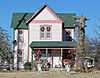 |
(#11000639) |
1350 W. Peckingham Rd. 36°53′01″N 97°04′10″W / 36.883611°N 97.069444°W |
Newkirk vicinity | |
| 34 | Soldani Mansion | 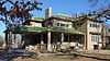 |
(#82003687) |
819 E. Central St. 36°42′09″N 97°04′25″W / 36.7025°N 97.073611°W |
Ponca City | Now the Ponca City Art Center. |
| 35 | J.P. Tipton Farmstead | Upload image | (#98000073) |
3.1 miles east of Newkirk 36°53′01″N 96°59′08″W / 36.883611°N 96.985556°W |
Newkirk | |
| 36 | Tonkawa Armory | |
(#88001363) |
3rd and North Sts. 36°41′25″N 97°18′10″W / 36.690278°N 97.302778°W |
Tonkawa | |
| 37 | Tonkawa Lodge No. 157 A.F. & A.M. | 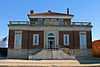 |
(#07000910) |
112 N. 7th St. 36°40′45″N 97°18′28″W / 36.679167°N 97.307778°W |
Tonkawa | |
| 38 | Washington Elementary School | 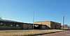 |
(#09000076) |
723 W. College Ave. 36°48′05″N 97°17′32″W / 36.801389°N 97.292222°W |
Blackwell | |
| 39 | Wentz Camp | Upload image | (#10000620) |
Intersection of L.A. Cann Dr. and E. Prospect Ave. 36°44′18″N 97°01′33″W / 36.738333°N 97.025833°W |
Ponca City | |
| 40 | White Eagle Park | Upload image | (#07000522) |
North of White Eagle Coordinates missing |
White Eagle |
See also
| Wikimedia Commons has media related to National Register of Historic Places in Kay County, Oklahoma. |
- List of National Historic Landmarks in Oklahoma
- National Register of Historic Places listings in Oklahoma
References
- ↑ The latitude and longitude information provided in this table was derived originally from the National Register Information System, which has been found to be fairly accurate for about 99% of listings. For about 1% of NRIS original coordinates, experience has shown that one or both coordinates are typos or otherwise extremely far off; some corrections may have been made. A more subtle problem causes many locations to be off by up to 150 yards, depending on location in the country: most NRIS coordinates were derived from tracing out latitude and longitudes off of USGS topographical quadrant maps created under the North American Datum of 1927, which differs from the current, highly accurate WGS84 GPS system used by most on-line maps. Chicago is about right, but NRIS longitudes in Washington are higher by about 4.5 seconds, and are lower by about 2.0 seconds in Maine. Latitudes differ by about 1.0 second in Florida. Some locations in this table may have been corrected to current GPS standards.
- ↑ "National Register of Historic Places: Weekly List Actions". National Park Service, United States Department of the Interior. Retrieved on May 1, 2015.
- ↑ Numbers represent an ordering by significant words. Various colorings, defined here, differentiate National Historic Landmarks and historic districts from other NRHP buildings, structures, sites or objects.
- ↑ "National Register Information System". National Register of Historic Places. National Park Service. 2009-03-13.
- ↑ The eight-digit number below each date is the number assigned to each location in the National Register Information System database, which can be viewed by clicking the number.
| ||||||||||||||||||||||||||
| |||||||||||||||||||||||||||||||||