National Register of Historic Places listings in Jones County, Iowa

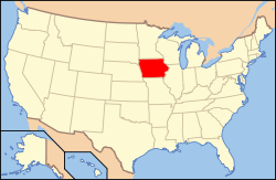
Location of Jones County in Iowa
This is a list of the National Register of Historic Places listings in Jones County, Iowa.
This is intended to be a complete list of the properties and districts on the National Register of Historic Places in Jones County, Iowa, United States. Latitude and longitude coordinates are provided for many National Register properties and districts; these locations may be seen together in a Google map.[1]
There are 27 properties and districts listed on the National Register in the county.
- This National Park Service list is complete through NPS recent listings posted May 1, 2015.[2]
| [3] | Name on the Register[4] | Image | Date listed[5] | Location | City or town | Description |
|---|---|---|---|---|---|---|
| 1 | Anamosa Main Street Historic District | 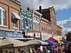 |
(#08001381) |
200 and 300 blocks of W. Main St., 100 block of E. Main St., 100 blocks of N. and S. Ford St., and 100 block of N. Garnavillo St. 42°06′30″N 91°17′13″W / 42.108239°N 91.286825°W |
Anamosa | |
| 2 | Anamosa Public Library | 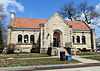 |
(#83000380) |
100 E. 1st St. 42°06′24″N 91°17′07″W / 42.10660278°N 91.28531389°W |
Anamosa | |
| 3 | Antioch School | 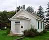 |
(#00001654) |
Iowa Highway 64, 4 miles (6.4 km) east of Anamosa 42°05′07″N 91°12′50″W / 42.085278°N 91.213889°W |
Anamosa | |
| 4 | Edmund and Mary Ann Walworth Booth House | Upload image | (#13000067) |
125 S. Ford St. 42°06′28″N 91°17′08″W / 42.107838°N 91.285554°W |
Anamosa | |
| 5 | Business Part of Olin Historic District | Upload image | (#14000907) |
Both sides of 300 blk. of E. Jackson and portion of E. 2nd Sts. 41°59′53″N 91°08′30″W / 41.998°N 91.1418°W |
Olin | |
| 6 | Dr. Martin H. Caulkins House and Office | 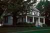 |
(#82002625) |
Washington and Main Sts. 42°03′30″N 91°00′16″W / 42.058333°N 91.004444°W |
Wyoming | |
| 7 | Corbett's/Eby's Mill Bridge | 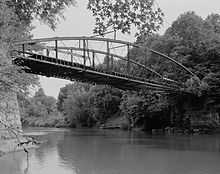 |
(#85000722) |
Spans the Maquoketa River 42°11′59″N 91°03′32″W / 42.199722°N 91.058889°W |
Scotch Grove Township | |
| 8 | Ely's Stone Bridge |  |
(#79000908) |
Northwest of Monticello at Hardscrabble Rd. 42°15′24″N 91°13′31″W / 42.256667°N 91.225278°W |
Monticello | |
| 9 | Farm No. 1, Iowa Men's Reformatory | 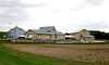 |
(#92001664) |
County Trunk Highway E28 west of Buffalo Creek 42°06′33″N 91°18′08″W / 42.109167°N 91.302222°W |
Anamosa | |
| 10 | S.S. Farwell House | 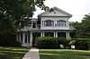 |
(#79000909) |
301 N. Chestnut St. 42°14′31″N 91°11′39″W / 42.241944°N 91.194167°W |
Monticello | |
| 11 | Fremont Mill Bridge | 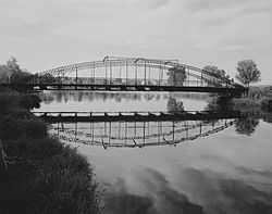 |
(#98000537) |
Pedestrian path over a small pond in Central Park 42°06′39″N 91°08′22″W / 42.110728°N 91.139351°W |
Anamosa | |
| 12 | John A. Green Estate | 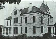 |
(#78001232) |
West of Anamosa off U.S. Route 151 42°06′40″N 91°21′05″W / 42.111111°N 91.351389°W |
Anamosa | |
| 13 | Hale Bridge | 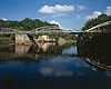 |
(#98000539) |
100th St. over the Wapsipinicon River above Oxford Junction 42°00′16″N 91°03′54″W / 42.00457°N 91.06511°W |
Hale Township | |
| 14 | Iowa Men's Reformatory Cemetery | 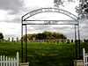 |
(#92001665) |
County Trunk Highway E28 west of Buffalo Creek 42°06′43″N 91°18′32″W / 42.111944°N 91.308889°W |
Anamosa | |
| 15 | Iowa Men's Reformatory Historic District | 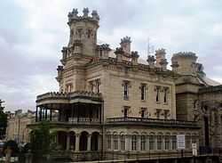 |
(#92001667) |
N. High St. 42°06′41″N 91°17′27″W / 42.111389°N 91.290833°W |
Anamosa | |
| 16 | Jones County Court House | 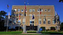 |
(#03000822) |
500 W. Main St. 42°06′34″N 91°17′24″W / 42.109444°N 91.29°W |
Anamosa | |
| 17 | Lower Road Bridge | 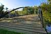 |
(#98000536) |
Buffalo Rd. over a branch of the Wapsipinicon River 42°06′53″N 91°18′21″W / 42.114779°N 91.305893°W |
Anamosa | |
| 18 | Moore's Ford Bridge | Upload image | (#98000538) |
25th Ave. over White Water Creek 42°16′47″N 90°55′40″W / 42.279722°N 90.927778°W |
Monticello | |
| 19 | Odd Fellows Hall | 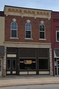 |
(#85001377) |
203 W. 1st St. 42°14′16″N 91°11′27″W / 42.237778°N 91.190833°W |
Monticello | |
| 20 | Rick's Brewery | Upload image | (#99000312) |
12412 Buffalo Rd. 42°06′48″N 91°18′00″W / 42.113333°N 91.3°W |
Anamosa | |
| 21 | St. Joseph's Roman Catholic Church | 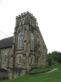 |
(#05000904) |
12472 County Road X28 42°07′06″N 91°21′39″W / 42.118333°N 91.360833°W |
Stone City | |
| 22 | St. Luke's Methodist Church | 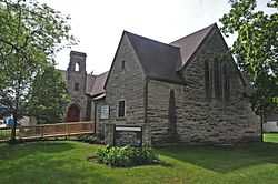 |
(#01001461) |
211 N. Sycamore 42°14′26″N 91°11′18″W / 42.240556°N 91.188333°W |
Monticello | |
| 23 | Scotch Grove Historic District | 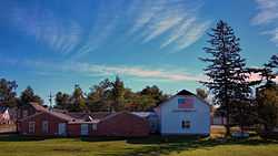 |
(#13001137) |
Junction of Iowa Highway 38, 116th Avenue, and County Road E17 42°10′21″N 91°06′26″W / 42.172382°N 91.107162°W |
Monticello | |
| 24 | Col. William T. and Elizabeth C. Shaw House | Upload image | (#92001636) |
509 S. Oak St. 42°06′07″N 91°16′18″W / 42.101944°N 91.271667°W |
Anamosa | |
| 25 | State Quarry, Iowa Men's Reformatory | Upload image | (#92001666) |
Unnamed road along the eastern side of Buffalo Creek northwest of Anamosa 42°07′23″N 91°19′08″W / 42.123056°N 91.318889°W |
Anamosa | |
| 26 | Stone City Historic District | 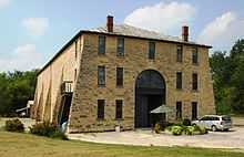 |
(#08001099) |
12828-12573 Stone City Rd., 12392-12340 Dearborn Rd., and 12381-12551 County Road X28 42°06′54″N 91°21′17″W / 42.115113°N 91.354691°W |
Stone City | |
| 27 | Wapsipinicon State Park Historic District | |
(#14000669) |
21301 Cty. Rd. E34 42°05′43″N 91°17′08″W / 42.0953°N 91.2856°W |
Anamosa |
See also
| Wikimedia Commons has media related to National Register of Historic Places in Jones County, Iowa. |
References
- ↑ The latitude and longitude information provided in this table was derived originally from the National Register Information System, which has been found to be fairly accurate for about 99% of listings. For about 1% of NRIS original coordinates, experience has shown that one or both coordinates are typos or otherwise extremely far off; some corrections may have been made. A more subtle problem causes many locations to be off by up to 150 yards, depending on location in the country: most NRIS coordinates were derived from tracing out latitude and longitudes off of USGS topographical quadrant maps created under the North American Datum of 1927, which differs from the current, highly accurate WGS84 GPS system used by most on-line maps. Chicago is about right, but NRIS longitudes in Washington are higher by about 4.5 seconds, and are lower by about 2.0 seconds in Maine. Latitudes differ by about 1.0 second in Florida. Some locations in this table may have been corrected to current GPS standards.
- ↑ "National Register of Historic Places: Weekly List Actions". National Park Service, United States Department of the Interior. Retrieved on May 1, 2015.
- ↑ Numbers represent an ordering by significant words. Various colorings, defined here, differentiate National Historic Landmarks and historic districts from other NRHP buildings, structures, sites or objects.
- ↑ "National Register Information System". National Register of Historic Places. National Park Service. 2008-04-24.
- ↑ The eight-digit number below each date is the number assigned to each location in the National Register Information System database, which can be viewed by clicking the number.
| ||||||||||||||||||||||||||

| |||||||||||||||||||||||||||||