| [3] |
Name on the Register |
Image |
Date listed[4] |
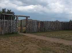
Location |
City or town |
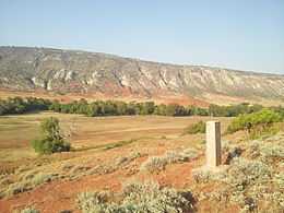
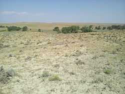
Description |
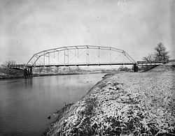
|---|
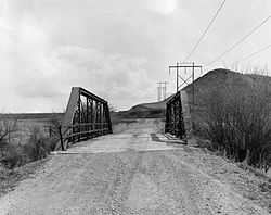
| 1 |
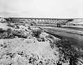
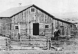
AJX Bridge over South Fork and Powder River |
|
01985-02-22-0000February 22, 1985
(#85000426) |
Interstate 25 W. Service Rd. (old U.S. Route 87)
43°37′13″N 106°34′35″W / 43.620278°N 106.576389°W / 43.620278; -106.576389 (AJX Bridge over South Fork and Powder River) |
Kaycee |
|
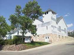
| 2 |
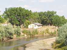
Beaver Creek Ranch Headquarters |
Upload image |
02014-01-08-0000January 8, 2014
(#13001064) |
2333 Beaver Creek
Coordinates missing |
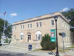
Buffalo vicinity |
|
| 3 |
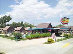
Blue Gables Motel |
|
02011-11-01-0000November 1, 2011
(#11000772) |
662 N. Main St.
44°21′20″N 106°41′56″W / 44.355597°N 106.698983°W / 44.355597; -106.698983 (Blue Gables Motel) |
Buffalo |
part of the Motor Courts and Motels in Wyoming MPS
|
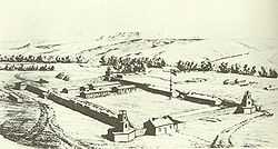
| 4 |
Cantonment Reno |
|
01977-07-29-0000July 29, 1977
(#77001382) |
5 miles north of Sussex at the Powder River
43°47′06″N 106°15′13″W / 43.785°N 106.253611°W / 43.785; -106.253611 (Cantonment Reno) |
Kaycee |
|
| 5 |
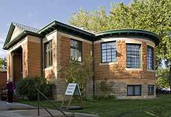
Carnegie Public Library |
|
01976-11-07-0000November 7, 1976
(#76001949) |
90 N. Main
44°20′53″N 106°41′58″W / 44.348056°N 106.699444°W / 44.348056; -106.699444 (Carnegie Public Library) |
Buffalo |
|
| 6 |
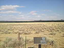
Dull Knife Battlefield |
|
01979-08-15-0000August 15, 1979
(#79002609) |
North of Barnum
43°45′36″N 106°56′55″W / 43.76°N 106.948611°W / 43.76; -106.948611 (Dull Knife Battlefield) |
Kaycee |
|
| 7 |
EDL Peloux Bridge |
|
01985-02-22-0000February 22, 1985
(#85000425) |
County Road CN16-40
44°21′47″N 106°39′14″W / 44.363056°N 106.653889°W / 44.363056; -106.653889 (EDL Peloux Bridge) |
Buffalo |
|
| 8 |
EDZ Irigary Bridge |
|
01985-02-22-0000February 22, 1985
(#85000427) |
County Road CN16-254
43°56′32″N 106°09′22″W / 43.942222°N 106.156111°W / 43.942222; -106.156111 (EDZ Irigary Bridge) |
Kaycee |
|
| 9 |
Fort McKinney |
Upload image |
01976-07-30-0000July 30, 1976
(#76001950) |
About 2 miles west of Buffalo on U.S. Route 16
44°19′55″N 106°44′05″W / 44.331944°N 106.734722°W / 44.331944; -106.734722 (Fort McKinney) |
Buffalo |
|
| 10 |
Fort Phil Kearny and Associated Sites |
|
01966-10-15-0000October 15, 1966
(#66000756) |
On state highway west off U.S. Route 87
44°32′54″N 106°49′21″W / 44.548333°N 106.8225°W / 44.548333; -106.8225 (Fort Phil Kearny and Associated Sites) |
Story |
|
| 11 |
Fort Reno |
|
01970-04-28-0000April 28, 1970
(#70000672) |
East of Sussex on the Powder River
43°49′42″N 106°14′26″W / 43.828333°N 106.240556°W / 43.828333; -106.240556 (Fort Reno) |
Kaycee |
|
| 12 |
HF Bar Ranch Historic District |
Upload image |
01984-11-07-0000November 7, 1984
(#84000392) |
Northwest of Buffalo
44°27′31″N 106°53′59″W / 44.458611°N 106.899722°W / 44.458611; -106.899722 (HF Bar Ranch Historic District) |
Buffalo |
|
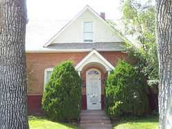
| 13 |
Holland House |
|
01993-11-04-0000November 4, 1993
(#93001185) |
312 N. Main St.
44°21′05″N 106°41′56″W / 44.351389°N 106.698889°W / 44.351389; -106.698889 (Holland House) |
Buffalo |
|
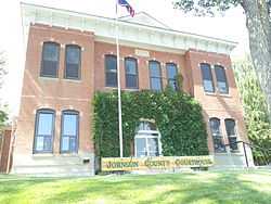
| 14 |
Johnson County Courthouse |
|
01976-11-07-0000November 7, 1976
(#76001951) |
76 N. Main St.
44°20′52″N 106°41′56″W / 44.347778°N 106.698889°W / 44.347778; -106.698889 (Johnson County Courthouse) |
Buffalo |
|
| 15 |
Lake Desmet Segment, Bozeman Trail |
|
01989-07-23-0000July 23, 1989
(#89000814) |
Address Restricted[5]
|
Buffalo |
|
| 16 |
Main Street Historic District |
|
01984-04-12-0000April 12, 1984
(#84003676) |
Main St.
44°20′48″N 106°41′53″W / 44.346667°N 106.698056°W / 44.346667; -106.698056 (Main Street Historic District) |
Buffalo |
|
| 17 |
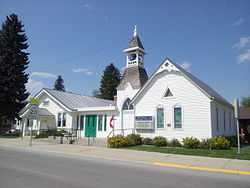
Methodist Episcopal Church |
|
01976-09-13-0000September 13, 1976
(#76001952) |
Fort and N. Adams Sts.
44°20′55″N 106°42′01″W / 44.348611°N 106.700278°W / 44.348611; -106.700278 (Methodist Episcopal Church) |
Buffalo |
|
| 18 |
Powder River Station-Powder River Crossing (48JO134 and 48JO801) |
|
01989-07-23-0000July 23, 1989
(#89000810) |
Address Restricted[5]
|
Kaycee |
|
| 19 |
St. Luke's Episcopal Church |
|
01976-11-07-0000November 7, 1976
(#76001953) |
178 S. Main
44°20′40″N 106°41′51″W / 44.344444°N 106.6975°W / 44.344444; -106.6975 (St. Luke's Episcopal Church) |
Buffalo |
|
| 20 |
Sussex Post Office and Store |
|
01998-11-12-0000November 12, 1998
(#98001377) |
Sussex Rd. and the Powder River
43°41′52″N 106°17′40″W / 43.697778°N 106.294444°W / 43.697778; -106.294444 (Sussex Post Office and Store) |
Kaycee |
|
| 21 |
TA Ranch Historic District |
|
01993-03-26-0000March 26, 1993
(#93000198) |
East of Wyoming Highway 196 on the North Fork of the Crazy Woman Creek
44°09′18″N 106°40′13″W / 44.155°N 106.670278°W / 44.155; -106.670278 (TA Ranch Historic District) |
Buffalo |
|
| 22 |
Trabing Station-Crazy Woman Crossing |
|
01989-07-23-0000July 23, 1989
(#89000815) |
Address Restricted[5]
|
Buffalo |
|
| 23 |
Union Congregational Church and Parsonage |
|
01985-02-07-0000February 7, 1985
(#85000248) |
110 Bennett St.
44°20′43″N 106°41′45″W / 44.345278°N 106.695833°W / 44.345278; -106.695833 (Union Congregational Church and Parsonage) |
Buffalo |
|
| 24 |
US Post Office-Buffalo Main |
|
01987-05-19-0000May 19, 1987
(#87000785) |
193 S. Main St.
44°20′42″N 106°41′49″W / 44.345°N 106.696944°W / 44.345; -106.696944 (US Post Office-Buffalo Main) |
Buffalo |
|