National Register of Historic Places listings in Jerauld County, South Dakota

Location of Jerauld County in South Dakota
This is a list of the National Register of Historic Places listings in Jerauld County, South Dakota.
This is intended to be a complete list of the properties on the National Register of Historic Places in Jerauld County, South Dakota, United States. The locations of National Register properties for which the latitude and longitude coordinates are included below, may be seen in a Google map.[1]
There are 13 properties listed on the National Register in the county.
- This National Park Service list is complete through NPS recent listings posted May 1, 2015.[2]
Current listings
| [3] |
Name on the Register[4] |
Image |
Date listed[5] |
Location |
City or town |
Description |
|---|
| 1 |
Alpena Bathhouse and Swimming Pool |
Upload image |
02000-06-22-0000June 22, 2000
(#00000727) |
Junction of 5th and Main
44°10′58″N 98°22′14″W / 44.182778°N 98.370556°W / 44.182778; -98.370556 (Alpena Bathhouse and Swimming Pool) |
Alpena |
|
| 2 |
Archeological Site 39JE10 |
Upload image |
01984-02-23-0000February 23, 1984
(#84003336) |
Address Restricted
|
Wessington Springs |
|
| 3 |
Archeological Site 39JE11 |
Upload image |
01984-02-23-0000February 23, 1984
(#84003337) |
Address Restricted
|
Gann Valley |
|
| 4 |
Hawkeye Valley Mill |
Upload image |
02013-01-23-0000January 23, 2013
(#12001216) |
Southeastern ¼ of Section 23, Township 106 North, Range 65 West
43°58′19″N 98°35′30″W / 43.972025°N 98.591658°W / 43.972025; -98.591658 (Hawkeye Valley Mill) |
Wessington Springs |
|
| 5 |
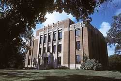
Jerauld County Courthouse |
|
01993-02-10-0000February 10, 1993
(#92001860) |
Junction of South Dakota Ave. and Burrett St.
44°04′42″N 98°34′10″W / 44.078333°N 98.569444°W / 44.078333; -98.569444 (Jerauld County Courthouse) |
Wessington Springs |
|
| 6 |
Methodist Episcopal Church of Wessington Springs |
Upload image |
01999-12-17-0000December 17, 1999
(#99001582) |
Southeastern corner of Main and State Sts.
44°04′47″N 98°34′18″W / 44.079722°N 98.571667°W / 44.079722; -98.571667 (Methodist Episcopal Church of Wessington Springs) |
Wessington Springs |
|
| 7 |
Municipal Field House |
Upload image |
02000-06-02-0000June 2, 2000
(#00000600) |
418 2nd St., SW.
44°04′37″N 98°34′19″W / 44.076944°N 98.571944°W / 44.076944; -98.571944 (Municipal Field House) |
Wessington Springs |
|
| 8 |
L.P. Nielson Barn |
Upload image |
02004-12-15-0000December 15, 2004
(#04001363) |
23251 393rd Ave.
44°01′03″N 98°22′24″W / 44.0175°N 98.373333°W / 44.0175; -98.373333 (L.P. Nielson Barn) |
Woonsocket |
|
| 9 |
Shakespeare Garden and Shay House |
Upload image |
01979-11-14-0000November 14, 1979
(#79003681) |
Off Highway 34
44°05′07″N 98°34′39″W / 44.085278°N 98.5775°W / 44.085278; -98.5775 (Shakespeare Garden and Shay House) |
Wessington Springs |
|
| 10 |
Robert S. Vessey House |
Upload image |
01978-04-26-0000April 26, 1978
(#78002560) |
118 College Ave.
44°04′44″N 98°34′24″W / 44.078889°N 98.573333°W / 44.078889; -98.573333 (Robert S. Vessey House) |
Wessington Springs |
|
| 11 |
Wessington Springs Carnegie Library |
Upload image |
01999-06-03-0000June 3, 1999
(#99000677) |
124 N. Main Ave.
44°04′45″N 98°34′19″W / 44.079167°N 98.571944°W / 44.079167; -98.571944 (Wessington Springs Carnegie Library) |
Wessington Springs |
|
| 12 |
Wessington Springs Opera House |
Upload image |
01976-07-21-0000July 21, 1976
(#76001738) |
111 Dakota Ave., N.
44°04′42″N 98°33′36″W / 44.078333°N 98.56°W / 44.078333; -98.56 (Wessington Springs Opera House) |
Wessington Springs |
|
| 13 |
H.P. Will House |
Upload image |
02003-02-05-0000February 5, 2003
(#02001763) |
214 Alene Ave., N.
44°04′51″N 98°34′32″W / 44.080833°N 98.575556°W / 44.080833; -98.575556 (H.P. Will House) |
Wessington Springs |
|
See also
References
- ↑ The latitude and longitude information provided in this table was derived originally from the National Register Information System, which has been found to be fairly accurate for about 99% of listings. For about 1% of NRIS original coordinates, experience has shown that one or both coordinates are typos or otherwise extremely far off; some corrections may have been made. A more subtle problem causes many locations to be off by up to 150 yards, depending on location in the country: most NRIS coordinates were derived from tracing out latitude and longitudes off of USGS topographical quadrant maps created under the North American Datum of 1927, which differs from the current, highly accurate WGS84 GPS system used by most on-line maps. Chicago is about right, but NRIS longitudes in Washington are higher by about 4.5 seconds, and are lower by about 2.0 seconds in Maine. Latitudes differ by about 1.0 second in Florida. Some locations in this table may have been corrected to current GPS standards.
- ↑ "National Register of Historic Places: Weekly List Actions". National Park Service, United States Department of the Interior. Retrieved on May 1, 2015.
- ↑ Numbers represent an ordering by significant words. Various colorings, defined here, differentiate National Historic Landmarks and historic districts from other NRHP buildings, structures, sites or objects.
- ↑ "National Register Information System". National Register of Historic Places. National Park Service. 2008-04-24.
- ↑ The eight-digit number below each date is the number assigned to each location in the National Register Information System database, which can be viewed by clicking the number.
|
|---|
| | Topics | |
|---|
| | Lists by states | |
|---|
| | Lists by insular areas | |
|---|
| | Lists by associated states | |
|---|
| | Other areas | |
|---|
|
-
 Category Category
-
 Portal Portal
-
 WikiProject WikiProject
|
|