| [3] |
Name on the Register[4] |
Image |
Date listed[5] |
Location |
City or town |
Description |
|---|
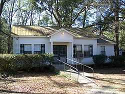
| 1 |
Bethel School |
|
02001-10-12-0000October 12, 2001
(#01001084) |
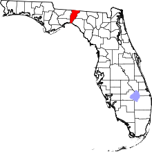
County Road 149
30°36′49″N 83°50′16″W / 30.613611°N 83.837778°W / 30.613611; -83.837778 (Bethel School) |
Monticello |
|
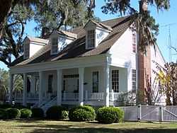
| 2 |
Denham-Lacy House |
|
01982-05-06-0000May 6, 1982
(#82002376) |
555 Palmer Mill Road
30°32′36″N 83°52′25″W / 30.543333°N 83.873611°W / 30.543333; -83.873611 (Denham-Lacy House) |
Monticello |
|
| 3 |
Dennis-Coxetter House |
|
01988-10-20-0000October 20, 1988
(#88002025) |
Junction of State Roads 59 and 158
30°28′41″N 84°01′23″W / 30.478056°N 84.023056°W / 30.478056; -84.023056 (Dennis-Coxetter House) |
Lloyd |
|
| 4 |
Girardeau House |
|
02011-06-30-0000June 30, 2011
(#11000382) |
950 East Washington Street
30°32′44″N 83°51′42″W / 30.545556°N 83.861667°W / 30.545556; -83.861667 (Girardeau House) |
Monticello |
|
| 5 |
Jefferson County Jail |
|
02014-01-15-0000January 15, 2014
(#13001072) |
380 West Dogwood Street
30°32′45″N 83°52′21″W / 30.545882°N 83.872528°W / 30.545882; -83.872528 (Jefferson County Jail) |
Monticello |
|
| 6 |
Letchworth Mounds Archaeological Site |
|
02010-12-15-0000December 15, 2010
(#10001034) |
4500 Sunray Road
30°31′19″N 83°59′26″W / 30.521944°N 83.990556°W / 30.521944; -83.990556 (Letchworth Mounds Archaeological Site) |
Tallahassee vicinity |
|
| 7 |
Lloyd Historic District |
|
01991-09-05-0000September 5, 1991
(#91001374) |
Roughly Main Street north of Bond Street and Bond east of Main
30°28′43″N 84°01′25″W / 30.478611°N 84.023611°W / 30.478611; -84.023611 (Lloyd Historic District) |
Lloyd |
There was a boundary decrease on June 27, 2002 (refnum 02000710)
|
| 8 |
Lloyd Railroad Depot |
|
01974-12-02-0000December 2, 1974
(#74000645) |
Near the junction of State Road 59 and Lester Lawrence Road
30°28′40″N 84°01′19″W / 30.477778°N 84.021944°W / 30.477778; -84.021944 (Lloyd Railroad Depot) |
Lloyd |
|
| 9 |
Lloyd Woman's Club |
|
01998-08-10-0000August 10, 1998
(#98000926) |
Bond Street
30°28′39″N 84°01′38″W / 30.4775°N 84.027222°W / 30.4775; -84.027222 (Lloyd Woman's Club) |
Lloyd |
Part of the Clubhouses of Florida's Woman's Clubs MPS
|
| 10 |
Lloyd-Bond House |
|
01984-11-01-0000November 1, 1984
(#84000198) |
Bond Street
30°28′41″N 84°01′24″W / 30.478056°N 84.023333°W / 30.478056; -84.023333 (Lloyd-Bond House) |
Lloyd |
|
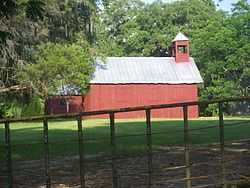
| 11 |
Lyndhurst Plantation |
|
01973-04-02-0000April 2, 1973
(#73000582) |
15 miles (24 km) northeast of Monticello off Ashville Road
30°35′15″N 83°39′11″W / 30.5875°N 83.653056°W / 30.5875; -83.653056 (Lyndhurst Plantation) |
Monticello |
|
| 12 |
Asa May House |
|
01972-12-15-0000December 15, 1972
(#72000329) |
North of the junction of U.S. Routes 19 and 27
30°24′52″N 83°54′40″W / 30.414444°N 83.911111°W / 30.414444; -83.911111 (Asa May House) |
Capps |
|
| 13 |
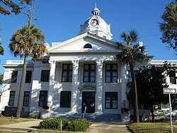
Monticello High School |
|
01999-03-25-0000March 25, 1999
(#99000373) |
425 West Washington Street
30°32′40″N 83°52′31″W / 30.544444°N 83.875278°W / 30.544444; -83.875278 (Monticello High School) |
Monticello |
|
| 14 |
Monticello Historic District |
|
01977-08-19-0000August 19, 1977
(#77000405) |
Irregular pattern along Madison, Jefferson, Dogwood, and Washington Streets
30°32′43″N 83°52′05″W / 30.545278°N 83.868056°W / 30.545278; -83.868056 (Monticello Historic District) |
Monticello |
|
| 15 |
Palmer House |
|
01978-11-21-0000November 21, 1978
(#78000947) |
Palmer Mill Road and South Jefferson Street
30°32′37″N 83°52′16″W / 30.543611°N 83.871111°W / 30.543611; -83.871111 (Palmer House) |
Monticello |
|
| 16 |
Palmer-Perkins House |
|
01979-07-10-0000July 10, 1979
(#79000674) |
625 West Palmer Mill Road; also Walnut Street
30°32′38″N 83°52′30″W / 30.543889°N 83.875°W / 30.543889; -83.875 (Palmer-Perkins House) |
Monticello |
Walnut represents a boundary increase
|
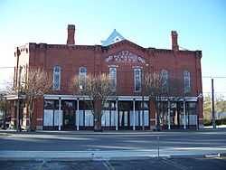
| 17 |
Perkins Opera House |
|
01972-09-14-0000September 14, 1972
(#72000330) |
Washington Street and Courthouse Square
30°32′41″N 83°52′15″W / 30.544722°N 83.870833°W / 30.544722; -83.870833 (Perkins Opera House) |
Monticello |
|
| 18 |
San Joseph de Ocuya Site |
|
01973-05-07-0000May 7, 1973
(#73000580) |
Address Restricted
|
Lloyd |
|
| 19 |
San Juan De Aspalaga Site |
|
01973-05-07-0000May 7, 1973
(#73000581) |
Address Restricted
|
Wacissa |
|
| 20 |
San Miguel de Asile Mission Site |
|
01974-12-17-0000December 17, 1974
(#74000644) |
Address Restricted
|
Lamont |
|
| 21 |
Turnbull-Ritter House |
|
01979-07-18-0000July 18, 1979
(#79000673) |
Northwest of Lamont off U.S. Route 19
30°28′28″N 83°54′18″W / 30.474444°N 83.905°W / 30.474444; -83.905 (Turnbull-Ritter House) |
Lamont |
|
| 22 |
Wirick-Simmons House |
|
01972-06-30-0000June 30, 1972
(#72000331) |
Jefferson and Pearl Streets
30°32′46″N 83°52′12″W / 30.546111°N 83.87°W / 30.546111; -83.87 (Wirick-Simmons House) |
Monticello |
|