National Register of Historic Places listings in Jackson County, Ohio
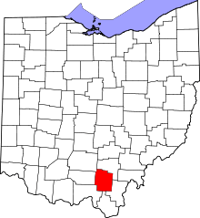
Location of Jackson County in Ohio
This is a list of the National Register of Historic Places listings in Jackson County, Ohio.
This is intended to be a complete list of the properties and districts on the National Register of Historic Places in Jackson County, Ohio, United States. The locations of National Register properties and districts for which the latitude and longitude coordinates are included below, may be seen in a Google map.[1]
There are 12 properties and districts listed on the National Register in the county.
- This National Park Service list is complete through NPS recent listings posted May 1, 2015.[2]
Current listings
| [3] |
Name on the Register[4] |
Image |
Date listed[5] |
Location |
City or town |
Description |
|---|
| 1 |
Buckeye Furnace |
Upload image |
01970-11-10-0000November 10, 1970
(#70000503) |
10 miles east of Jackson
39°03′24″N 82°27′13″W / 39.056667°N 82.453611°W / 39.056667; -82.453611 (Buckeye Furnace) |
Milton Township |
|
| 2 |
Buckeye Furnace Covered Bridge |
Upload image |
01975-02-24-0000February 24, 1975
(#75001442) |
3 miles southeast of Wellston on State Route 165
39°03′16″N 82°27′35″W / 39.054444°N 82.459722°W / 39.054444; -82.459722 (Buckeye Furnace Covered Bridge) |
Milton Township |
|
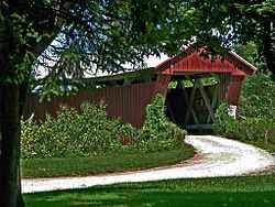
| 3 |
Byer Covered Bridge |
Upload image |
01975-10-21-0000October 21, 1975
(#75001441) |
State Route 31 south of Byer
39°10′46″N 82°37′52″W / 39.179444°N 82.631111°W / 39.179444; -82.631111 (Byer Covered Bridge) |
Washington Township |
|
| 4 |
Clutts House |
|
01980-11-26-0000November 26, 1980
(#80003105) |
16 E. Broadway St.
39°07′25″N 82°32′04″W / 39.123611°N 82.534444°W / 39.123611; -82.534444 (Clutts House) |
Wellston |
|
| 5 |
Gibson House |
Upload image |
01985-12-05-0000December 5, 1985
(#85003045) |
187 Main St.
39°03′10″N 82°38′17″W / 39.052778°N 82.638056°W / 39.052778; -82.638056 (Gibson House) |
Jackson |
|
| 6 |
Johnson Road Covered Bridge |
|
01984-08-23-0000August 23, 1984
(#84003749) |
Johnson Rd. near Petersburg
38°57′31″N 82°47′16″W / 38.958611°N 82.787778°W / 38.958611; -82.787778 (Johnson Road Covered Bridge) |
Scioto Township |
|
| 7 |
Keystone Furnace |
Upload image |
01982-03-18-0000March 18, 1982
(#82003600) |
Keystone Rd., southeast of Wellston[6]
39°00′39″N 82°27′06″W / 39.010833°N 82.451778°W / 39.010833; -82.451778 (Keystone Furnace) |
Bloomfield Township |
|
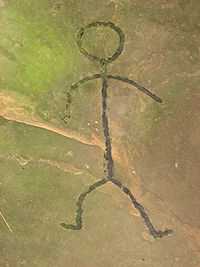
| 8 |
Leo Petroglyph |
|
01970-11-10-0000November 10, 1970
(#70000501) |
West of Leo
39°08′59″N 82°40′33″W / 39.149722°N 82.675833°W / 39.149722; -82.675833 (Leo Petroglyph) |
Jackson Township |
|
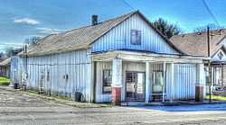
| 9 |
Miner's Supply Store |
|
01977-11-01-0000November 1, 1977
(#77001069) |
Main and 2nd Sts.
39°06′48″N 82°36′38″W / 39.113333°N 82.610556°W / 39.113333; -82.610556 (Miner's Supply Store) |
Coalton |
|
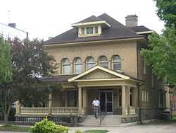
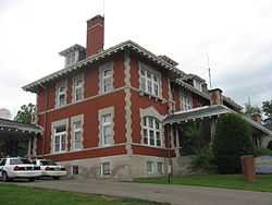
| 10 |
Morgan Mansion |
|
01979-02-16-0000February 16, 1979
(#79001867) |
Broadway and Pennsylvania Aves.
39°07′25″N 82°31′59″W / 39.123611°N 82.533056°W / 39.123611; -82.533056 (Morgan Mansion) |
Wellston |
|
| 11 |
Oak Hill Welsh Congregational Church |
|
01978-05-23-0000May 23, 1978
(#78002090) |
412 E. Main St.
38°53′44″N 82°34′09″W / 38.895556°N 82.569167°W / 38.895556; -82.569167 (Oak Hill Welsh Congregational Church) |
Oak Hill |
|
| 12 |
Scioto Grange No. 1234 |
Upload image |
02005-02-09-0000February 9, 2005
(#05000030) |
255 Cove Rd.
39°00′49″N 82°44′52″W / 39.013611°N 82.747778°W / 39.013611; -82.747778 (Scioto Grange No. 1234) |
Scioto Township |
|
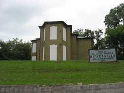
| 13 |
Harvey Wells House |
|
02009-04-14-0000April 14, 2009
(#09000211) |
403 E. A St.
39°07′27″N 82°31′49″W / 39.124217°N 82.530361°W / 39.124217; -82.530361 (Harvey Wells House) |
Wellston |
|
See also
References
- ↑ The latitude and longitude information provided in this table was derived originally from the National Register Information System, which has been found to be fairly accurate for about 99% of listings. For about 1% of NRIS original coordinates, experience has shown that one or both coordinates are typos or otherwise extremely far off; some corrections may have been made. A more subtle problem causes many locations to be off by up to 150 yards, depending on location in the country: most NRIS coordinates were derived from tracing out latitude and longitudes off of USGS topographical quadrant maps created under the North American Datum of 1927, which differs from the current, highly accurate WGS84 GPS system used by most on-line maps. Chicago is about right, but NRIS longitudes in Washington are higher by about 4.5 seconds, and are lower by about 2.0 seconds in Maine. Latitudes differ by about 1.0 second in Florida. Some locations in this table may have been corrected to current GPS standards.
- ↑ "National Register of Historic Places: Weekly List Actions". National Park Service, United States Department of the Interior. Retrieved on May 1, 2015.
- ↑ Numbers represent an ordering by significant words. Various colorings, defined here, differentiate National Historic Landmarks and historic districts from other NRHP buildings, structures, sites or objects.
- ↑ "National Register Information System". National Register of Historic Places. National Park Service. 2008-04-24.
- ↑ The eight-digit number below each date is the number assigned to each location in the National Register Information System database, which can be viewed by clicking the number.
- ↑ Location derived from this Forgotten Ohio webpage; the NRIS lists the site as "Address Restricted"
|
|---|
| | Lists by county | | |
|---|
| | Lists by city | |
|---|
| | Other lists | |
|---|
| |
|
.jpg)