National Register of Historic Places listings in Jackson County, Florida
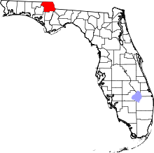
Location of Jackson County in Florida
This is a list of the National Register of Historic Places listings in Jackson County, Florida.
This is intended to be a complete list of the properties and districts on the National Register of Historic Places in Jackson County, Florida, United States. The locations of National Register properties and districts for which the latitude and longitude coordinates are included below, may be seen in a Google map.[1]
There are 10 properties and districts listed on the National Register in the county.
- This National Park Service list is complete through NPS recent listings posted May 1, 2015.[2]
Current listings
| [3] |
Name on the Register[4] |
Image |
Date listed[5] |
Location |
City or town |
Description |
|---|
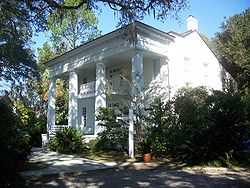
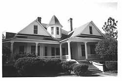
| 1 |
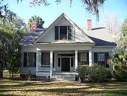
Ely-Criglar House |
|
01972-12-27-0000December 27, 1972
(#72000326) |
242 West Lafayette Street
30°46′34″N 85°14′05″W / 30.776111°N 85.234722°W / 30.776111; -85.234722 (Ely-Criglar House) |
Marianna |
|
| 2 |
Erwin House |
|
01974-06-05-0000June 5, 1974
(#74000642) |
Fort Road east of State Road 71
30°52′12″N 85°09′53″W / 30.87°N 85.164722°W / 30.87; -85.164722 (Erwin House) |
Greenwood |
|
| 3 |
Great Oaks |
|
01972-12-05-0000December 5, 1972
(#72000325) |
South of the junction of State Roads 69 and 71
30°52′12″N 85°09′43″W / 30.87°N 85.161944°W / 30.87; -85.161944 (Great Oaks) |
Greenwood |
|
| 4 |
Marianna Historic District (Marianna, Florida) |
|
01997-05-23-0000May 23, 1997
(#97000456) |
Bounded by Davis, Park, Jackson, and Wynn Streets
30°46′40″N 85°13′29″W / 30.777778°N 85.224722°W / 30.777778; -85.224722 (Marianna Historic District (Marianna, Florida)) |
Marianna |
Part of the Marianna MPS
|
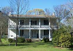
| 5 |
Robert Lee Norton House |
|
01996-08-22-0000August 22, 1996
(#96000914) |
2045 Church Street
30°42′49″N 85°04′25″W / 30.713611°N 85.073611°W / 30.713611; -85.073611 (Robert Lee Norton House) |
Cypress |
|
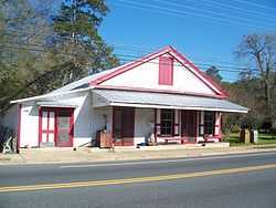
| 6 |
Pender's Store |
|
01974-05-03-0000May 3, 1974
(#74000643) |
Near the junction of State Roads 69 and 71
30°52′13″N 85°09′44″W / 30.870278°N 85.162222°W / 30.870278; -85.162222 (Pender's Store) |
Greenwood |
|
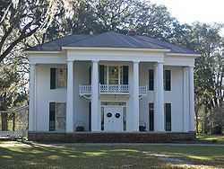
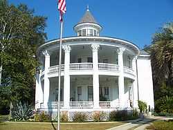
| 7 |
Joseph W. Russ Jr. House |
|
01983-07-18-0000July 18, 1983
(#83001425) |
310 West Lafayette Street
30°46′38″N 85°14′09″W / 30.777222°N 85.235833°W / 30.777222; -85.235833 (Joseph W. Russ Jr. House) |
Marianna |
|
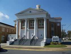
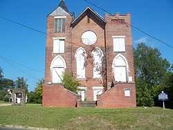
| 8 |
St. Luke Baptist Church |
|
02003-02-12-0000February 12, 2003
(#03000008) |
4476 East Jackson Street
30°46′23″N 85°13′24″W / 30.773056°N 85.223333°W / 30.773056; -85.223333 (St. Luke Baptist Church) |
Marianna |
|
| 9 |
Waddells Mill Pond Site |
|
01972-12-15-0000December 15, 1972
(#72000327) |
Address Restricted
|
Marianna |
|
| 10 |
Theophilus West House |
|
01972-12-26-0000December 26, 1972
(#72000328) |
403 Putnam Street
30°46′43″N 85°13′32″W / 30.778611°N 85.225556°W / 30.778611; -85.225556 (Theophilus West House) |
Marianna |
|
See also
References
- ↑ The latitude and longitude information provided in this table was derived originally from the National Register Information System, which has been found to be fairly accurate for about 99% of listings. For about 1% of NRIS original coordinates, experience has shown that one or both coordinates are typos or otherwise extremely far off; some corrections may have been made. A more subtle problem causes many locations to be off by up to 150 yards, depending on location in the country: most NRIS coordinates were derived from tracing out latitude and longitudes off of USGS topographical quadrant maps created under the North American Datum of 1927, which differs from the current, highly accurate WGS84 GPS system used by most on-line maps. Chicago is about right, but NRIS longitudes in Washington are higher by about 4.5 seconds, and are lower by about 2.0 seconds in Maine. Latitudes differ by about 1.0 second in Florida. Some locations in this table may have been corrected to current GPS standards.
- ↑ "National Register of Historic Places: Weekly List Actions". National Park Service, United States Department of the Interior. Retrieved on May 1, 2015.
- ↑ Numbers represent an ordering by significant words. Various colorings, defined here, differentiate National Historic Landmarks and historic districts from other NRHP buildings, structures, sites or objects.
- ↑ "National Register Information System". National Register of Historic Places. National Park Service. 2009-03-13.
- ↑ The eight-digit number below each date is the number assigned to each location in the National Register Information System database, which can be viewed by clicking the number.
|
|---|
| | Lists by county | | |
|---|
| | Lists by city | |
|---|
| | Other lists | |
|---|
| |
|