National Register of Historic Places listings in Jackson County, Arkansas

Location of Jackson County in Arkansas
This is a list of the National Register of Historic Places listings in Jackson County, Arkansas.
This is intended to be a complete list of the properties and districts on the National Register of Historic Places in Jackson County, Arkansas, United States. The locations of National Register properties and districts for which the latitude and longitude coordinates are included below, may be seen in a Google map.[1]
There are 15 properties and districts listed on the National Register in the county. Four other sites were once listed but have been removed.
- This National Park Service list is complete through NPS recent listings posted May 1, 2015.[2]
Current listings
| [3] | Name on the Register[4] | Image | Date listed[5] | Location | City or town | Description |
|---|---|---|---|---|---|---|
| 1 | Arkansas Bank & Trust Company | _Newport_AR.JPG) |
(#86002859) |
103 Walnut St. 35°36′21″N 91°17′00″W / 35.605833°N 91.283333°W |
Newport | |
| 2 | Empie-Van Dyke House | 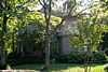 |
(#77000257) |
403 Laurel 35°36′17″N 91°16′43″W / 35.604722°N 91.278611°W |
Newport | |
| 3 | Erwin Auxiliary Army Airfield | 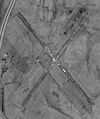 |
(#08000954) |
Northeast of the junction of Highway 14 and County Road 917 35°34′17″N 91°15′15″W / 35.571262°N 91.254258°W |
Newport | part of the World War II Home Front Efforts in Arkansas Multiple Property Submission (MPS) |
| 4 | First Presbyterian Church | 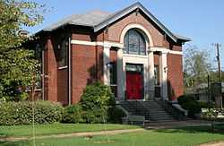 |
(#82000837) |
4th and Main Sts. 35°36′12″N 91°16′55″W / 35.603333°N 91.281944°W |
Newport | part of the Charles L. Thompson Design Collection Thematic Resource (TR) |
| 5 | Gregg House | 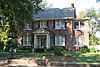 |
(#82000838) |
412 Pine St. 35°36′36″N 91°17′04″W / 35.61°N 91.284444°W |
Newport | part of the Charles L. Thompson Design Collection TR |
| 6 | Jackson County Courthouse | 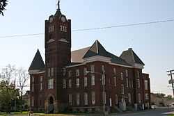 |
(#76000421) |
U.S. Route 67 35°36′13″N 91°16′58″W / 35.603611°N 91.282778°W |
Newport | |
| 7 | Jackson Guards Memorial | 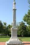 |
(#96000465) |
In Jacksonport State Park at the junction of Washington and Avenue Sts. 35°38′21″N 91°18′43″W / 35.639167°N 91.311944°W |
Jacksonport | part of the Civil War Commemorative Sculpture MPS |
| 8 | Jacksonport State Park |  |
(#70000121) |
Between Dillard St. and the White River 35°38′19″N 91°18′19″W / 35.638611°N 91.305278°W |
Jacksonport | |
| 9 | Missouri-Pacific Depot-Newport |  |
(#92000619) |
Northwest of the junction of Walnut and Front Sts. 35°36′23″N 91°17′00″W / 35.606389°N 91.283333°W |
Newport | part of the Historic Railroad Depots of Arkansas MPS |
| 10 | New Home School Building | Upload image | (#92001357) |
County Road 69 northwest of Swifton 35°50′38″N 91°10′24″W / 35.843889°N 91.173333°W |
Swifton | |
| 11 | Newport American Legion Community Hut | 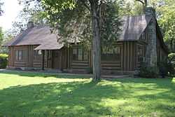 |
(#92001672) |
Remmel Park, north of Remmel Ave. 35°36′03″N 91°16′32″W / 35.600833°N 91.275556°W |
Newport | |
| 12 | Newport Bridge | .jpg) |
(#90000503) |
U.S. Route 67 over the White River 35°36′33″N 91°17′21″W / 35.609167°N 91.289167°W |
Newport | part of the Historic Bridges of Arkansas MPS |
| 13 | Newport Junior & Senior High School | 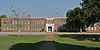 |
(#82000839) |
Remmel Park 35°36′03″N 91°16′21″W / 35.600833°N 91.2725°W |
Newport | part of the Charles L. Thompson Design Collection TR |
| 14 | Tuckerman Water Tower | 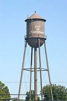 |
(#07000443) |
Southern end of Front St. 35°43′46″N 91°12′01″W / 35.729444°N 91.200278°W |
Tuckerman | part of the New Deal Recovery Efforts in Arkansas MPS |
| 15 | Weldon Gin Company Historic District | Upload image | (#08000487) |
Northeastern corner of the junction of Washington St. and Highway 17 35°26′50″N 91°13′49″W / 35.447298°N 91.230385°W |
Weldon | part of the Cotton and Rice Farm History and Architecture in the Arkansas Delta MPS |
Former listing
| [3] | Name on the Register | Image | Date listed | Date removed | Location | City or town | Summary |
|---|---|---|---|---|---|---|---|
| 1 | Hickory Grove Church and School | Upload image | (#78000595) | N of Jacksonport 35°36′17″N 91°16′56″W / 35.6047°N 91.2822°W |
Jacksonport | ||
| 2 | Jackson County Jail | 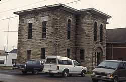 |
(#79003432) | 503 3rd St. 35°36′17″N 91°16′56″W / 35.6047°N 91.2822°W |
Newport | ||
| 3 | Phillips 66 Station | 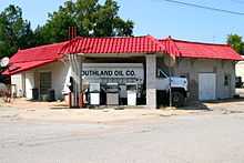 |
(#00000605) | Northern corner of W. 1st and Main Sts. 35°49′31″N 91°07′56″W / 35.825278°N 91.132222°W |
Swifton | part of the Arkansas Highway History and Architecture MPS | |
| 4 | Rock Island Depot-Weldon | Upload image | (#92000621) | Highway 17 35°26′58″N 91°13′48″W / 35.449444°N 91.23°W |
Weldon | part of the Historic Railroad Depots of Arkansas MPS |
See also
| Wikimedia Commons has media related to National Register of Historic Places in Jackson County, Arkansas. |
- List of National Historic Landmarks in Arkansas
- National Register of Historic Places listings in Arkansas
References
- ↑ The latitude and longitude information provided in this table was derived originally from the National Register Information System, which has been found to be fairly accurate for about 99% of listings. For about 1% of NRIS original coordinates, experience has shown that one or both coordinates are typos or otherwise extremely far off; some corrections may have been made. A more subtle problem causes many locations to be off by up to 150 yards, depending on location in the country: most NRIS coordinates were derived from tracing out latitude and longitudes off of USGS topographical quadrant maps created under the North American Datum of 1927, which differs from the current, highly accurate WGS84 GPS system used by most on-line maps. Chicago is about right, but NRIS longitudes in Washington are higher by about 4.5 seconds, and are lower by about 2.0 seconds in Maine. Latitudes differ by about 1.0 second in Florida. Some locations in this table may have been corrected to current GPS standards.
- ↑ "National Register of Historic Places: Weekly List Actions". National Park Service, United States Department of the Interior. Retrieved on May 1, 2015.
- ↑ 3.0 3.1 Numbers represent an ordering by significant words. Various colorings, defined here, differentiate National Historic Landmarks and historic districts from other NRHP buildings, structures, sites or objects.
- ↑ "National Register Information System". National Register of Historic Places. National Park Service. 2009-03-13.
- ↑ The eight-digit number below each date is the number assigned to each location in the National Register Information System database, which can be viewed by clicking the number.
| ||||||||||||||||||||||||||
| |||||||||||||||||||||||||