National Register of Historic Places listings in Huron County, Ohio
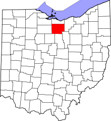
Location of Huron County in Ohio
This is a list of the National Register of Historic Places listings in Huron County, Ohio.
This is intended to be a complete list of the properties and districts on the National Register of Historic Places in Huron County, Ohio, United States. The locations of National Register properties and districts for which the latitude and longitude coordinates are included below, may be seen in a Google map.[1]
There are 17 properties and districts listed on the National Register in the county. Another property was once listed but has been removed.
- This National Park Service list is complete through NPS recent listings posted May 1, 2015.[2]
Current listings
| [3] |
Name on the Register[4] |
Image |
Date listed[5] |
Location |
City or town |
Description |
|---|
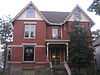
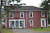
| 1 |
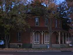
Dr. David De Forest Benedict House |
|
01975-01-23-0000January 23, 1975
(#75001439) |
80 Seminary St.
41°14′34″N 82°36′42″W / 41.242778°N 82.611667°W / 41.242778; -82.611667 (Dr. David De Forest Benedict House) |
Norwalk |
|
| 2 |
Seth Brown House |
|
01974-05-03-0000May 3, 1974
(#74001531) |
29 Brown St.
41°14′41″N 82°41′49″W / 41.244722°N 82.696944°W / 41.244722; -82.696944 (Seth Brown House) |
Monroeville |
|
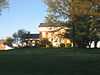
| 3 |
Dunton House |
|
01982-12-16-0000December 16, 1982
(#82001469) |
130 Benedict Ave.
41°14′13″N 82°36′43″W / 41.236806°N 82.611806°W / 41.236806; -82.611806 (Dunton House) |
Norwalk |
|
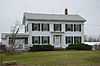
| 4 |
Gregory House |
|
01984-02-24-0000February 24, 1984
(#84003746) |
1 E. Main St.
41°05′08″N 82°23′57″W / 41.085417°N 82.399167°W / 41.085417; -82.399167 (Gregory House) |
New London |
|
| 5 |
John Hosford House |
|
01974-05-03-0000May 3, 1974
(#74001532) |
64 Sandusky St.
41°14′45″N 82°41′46″W / 41.245833°N 82.696111°W / 41.245833; -82.696111 (John Hosford House) |
Monroeville |
|
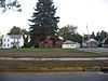
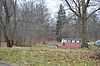
| 6 |
Hunts Corners |
|
01993-09-02-0000September 2, 1993
(#93000896) |
Junction of Sandhill Rd. and State Route 547 at Hunts Corners
41°13′37″N 82°45′26″W / 41.226944°N 82.757222°W / 41.226944; -82.757222 (Hunts Corners) |
Lyme Township |
One of Huron County's oldest communities, founded in 1811
|
| 7 |
Huron County Children's Home |
|
02004-10-27-0000October 27, 2004
(#04001200) |
190 Benedict Ave.
41°13′55″N 82°36′30″W / 41.231944°N 82.608333°W / 41.231944; -82.608333 (Huron County Children's Home) |
Norwalk |
|
| 8 |
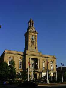
Huron County Courthouse and Jail |
|
01974-07-12-0000July 12, 1974
(#74001534) |
E. Main St. and Benedict Ave.
41°14′31″N 82°36′55″W / 41.241944°N 82.615278°W / 41.241944; -82.615278 (Huron County Courthouse and Jail) |
Norwalk |
|
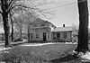
| 9 |
Macksville Tavern |
|
01976-05-03-0000May 3, 1976
(#76001457) |
Peru Hollow Rd.
41°10′11″N 82°38′32″W / 41.169722°N 82.642222°W / 41.169722; -82.642222 (Macksville Tavern) |
Peru Township |
|
| 10 |
Mead-Zimmerman House |
|
01978-03-30-0000March 30, 1978
(#78002089) |
East of Greenwich on State Route 13
41°00′56″N 82°29′08″W / 41.015556°N 82.485556°W / 41.015556; -82.485556 (Mead-Zimmerman House) |
Greenwich Township |
|
| 11 |
Miller-Bissell Farmstead |
|
02002-09-23-0000September 23, 2002
(#02001058) |
581 State Route 60, north of New London
41°07′19″N 82°24′34″W / 41.121944°N 82.409444°W / 41.121944; -82.409444 (Miller-Bissell Farmstead) |
New London Township |
|
| 12 |
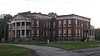
Norwalk Memorial Hospital |
|
02007-06-21-0000June 21, 2007
(#07000582) |
269 W. Main St.
41°14′01″N 82°38′17″W / 41.233611°N 82.6380856°W / 41.233611; -82.6380856 (Norwalk Memorial Hospital) |
Norwalk |
|
| 13 |
Phoenix Mills |
|
01975-05-28-0000May 28, 1975
(#75001440) |
East of Steuben on Mill Rd.
41°05′57″N 82°39′53″W / 41.099167°N 82.664722°W / 41.099167; -82.664722 (Phoenix Mills) |
Greenfield Township |
|
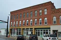
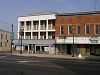
| 14 |
Tremont House |
|
02006-03-31-0000March 31, 2006
(#06000201) |
101-103 E. Main St.
41°16′26″N 82°50′26″W / 41.27383°N 82.84065°W / 41.27383; -82.84065 (Tremont House) |
Bellevue |
|
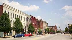
| 15 |
West Main Street District |
|
01974-02-27-0000February 27, 1974
(#74001535) |
In an irregular pattern, both sides of W. Main St. for 6 blocks from the western edge of business district
41°14′20″N 82°37′30″W / 41.238889°N 82.625°W / 41.238889; -82.625 (West Main Street District) |
Norwalk |
|
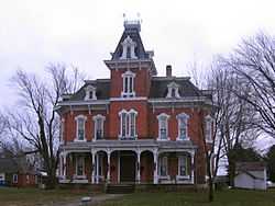
| 16 |
John Wright Mansion |
|
01974-02-27-0000February 27, 1974
(#74001530) |
State Route 113 west of State Route 4, northeast of Bellevue
41°16′53″N 82°47′25″W / 41.281389°N 82.790278°W / 41.281389; -82.790278 (John Wright Mansion) |
Lyme Township |
|
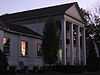
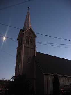
| 17 |
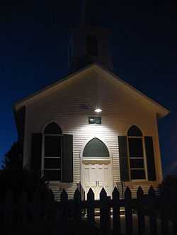
Zion Episcopal Church |
|
01974-05-03-0000May 3, 1974
(#74001533) |
Ridge St. at Monroe St.
41°14′35″N 82°42′13″W / 41.242917°N 82.703611°W / 41.242917; -82.703611 (Zion Episcopal Church) |
Monroeville |
|
Former listing
| [3] |
Name on the Register |
Image |
Date listed | Date removed |
Location |
City or town |
Summary |
|---|
| 1 |
Baltimore and Ohio Railroad Depot |
Upload image |
Unavailable
(#75002166) | 01978-01-01-00001978 |
B&O RR jct.
|
Willard |
Former B&O railroad junction |
See also
References
- ↑ The latitude and longitude information provided in this table was derived originally from the National Register Information System, which has been found to be fairly accurate for about 99% of listings. For about 1% of NRIS original coordinates, experience has shown that one or both coordinates are typos or otherwise extremely far off; some corrections may have been made. A more subtle problem causes many locations to be off by up to 150 yards, depending on location in the country: most NRIS coordinates were derived from tracing out latitude and longitudes off of USGS topographical quadrant maps created under the North American Datum of 1927, which differs from the current, highly accurate WGS84 GPS system used by most on-line maps. Chicago is about right, but NRIS longitudes in Washington are higher by about 4.5 seconds, and are lower by about 2.0 seconds in Maine. Latitudes differ by about 1.0 second in Florida. Some locations in this table may have been corrected to current GPS standards.
- ↑ "National Register of Historic Places: Weekly List Actions". National Park Service, United States Department of the Interior. Retrieved on May 1, 2015.
- ↑ 3.0 3.1 Numbers represent an ordering by significant words. Various colorings, defined here, differentiate National Historic Landmarks and historic districts from other NRHP buildings, structures, sites or objects.
- ↑ "National Register Information System". National Register of Historic Places. National Park Service. 2009-03-13.
- ↑ The eight-digit number below each date is the number assigned to each location in the National Register Information System database, which can be viewed by clicking the number.
|
|---|
| | Lists by county | | |
|---|
| | Lists by city | |
|---|
| | Other lists | |
|---|
| |
|