National Register of Historic Places listings in Humphreys County, Tennessee
Location of Humphreys County in Tennessee
This is a list of the National Register of Historic Places listings in Humphreys County, Tennessee.
This is intended to be a complete list of the properties and districts on the National Register of Historic Places in Humphreys County, Tennessee, United States. Latitude and longitude coordinates are provided for many National Register properties and districts; these locations may be seen together in a Google map.[1]
There are 10 properties and districts listed on the National Register in the county.
| Anderson – Bedford – Benton – Bledsoe – Blount – Bradley – Campbell – Cannon – Carroll – Carter – Cheatham – Chester – Claiborne – Clay – Cocke – Coffee – Crockett – Cumberland – Davidson – Decatur – DeKalb – Dickson – Dyer – Fayette – Fentress – Franklin – Gibson – Giles – Grainger – Greene – Grundy – Hamblen – Hamilton – Hancock – Hardeman – Hardin – Hawkins – Haywood – Henderson – Henry – Hickman – Houston – Humphreys – Jackson – Jefferson – Johnson – Knox – Lake – Lauderdale – Lawrence – Lewis – Lincoln – Loudon – Macon – Madison – Marion – Marshall – Maury – McMinn – McNairy – Meigs – Monroe – Montgomery – Moore – Morgan – Obion – Overton – Perry – Pickett – Polk – Putnam – Rhea – Roane – Robertson – Rutherford – Scott – Sequatchie – Sevier – Shelby – Smith – Stewart – Sullivan – Sumner – Tipton – Trousdale – Unicoi – Union – Van Buren – Warren – Washington – Wayne – Weakley – White – Williamson – Wilson |
- This National Park Service list is complete through NPS recent listings posted May 1, 2015.[2]
Current listings
| [3] | Name on the Register[4] | Image | Date listed[5] | Location | City or town | Description |
|---|---|---|---|---|---|---|
| 1 | Enochs Mill | Upload image | (#99001138) |
3072 Little Blue Creek Rd. 36°04′42″N 87°41′12″W / 36.078333°N 87.686667°W |
McEwen | |
| 2 | Fairchance Furnace (40HS168) | Upload image | (#88001143) |
Address Restricted |
Halls Creek | |
| 3 | Fort Hill and Archibald D. Butterfield House | 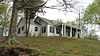 |
(#01000101) |
201 Fort Hill Dr. 36°04′54″N 87°47′32″W / 36.081667°N 87.792222°W |
Waverly | |
| 4 | Greyhound Half-Way House |  |
(#99001588) |
124 E. Main St. 36°04′58″N 87°47′34″W / 36.082778°N 87.792778°W |
Waverly | |
| 5 | Hurricane Mills Rural Historic District | Upload image | (#99001449) |
44 Hurricane Mills Rd. 35°57′53″N 87°47′08″W / 35.964722°N 87.785556°W |
Hurricane Mills | |
| 6 | Johnsonville Historic District | Upload image | (#01000257) |
Old Johnsonville Rd. 36°03′31″N 87°58′33″W / 36.058611°N 87.975833°W |
Denver | |
| 7 | Link Farm Site | Upload image | (#73001791) |
Address Restricted |
Hurricane Mills | |
| 8 | Hugh M. McAdoo House | 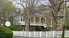 |
(#91001595) |
113 N. Church St. 36°05′03″N 87°47′36″W / 36.084028°N 87.793333°W |
Waverly | |
| 9 | James N. Nolan House | 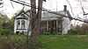 |
(#86000395) |
State Route 13N 36°05′17″N 87°47′37″W / 36.088056°N 87.793611°W |
Waverly | |
| 10 | Sycamore Landing | Upload image | (#80003837) |
Sycamore Landing Rd. 35°56′09″N 87°54′54″W / 35.935833°N 87.915°W |
Sycamore Landing |
See also
| Wikimedia Commons has media related to National Register of Historic Places in Humphreys County, Tennessee. |
- List of National Historic Landmarks in Tennessee
- National Register of Historic Places listings in Tennessee
References
- ↑ The latitude and longitude information provided in this table was derived originally from the National Register Information System, which has been found to be fairly accurate for about 99% of listings. For about 1% of NRIS original coordinates, experience has shown that one or both coordinates are typos or otherwise extremely far off; some corrections may have been made. A more subtle problem causes many locations to be off by up to 150 yards, depending on location in the country: most NRIS coordinates were derived from tracing out latitude and longitudes off of USGS topographical quadrant maps created under the North American Datum of 1927, which differs from the current, highly accurate WGS84 GPS system used by most on-line maps. Chicago is about right, but NRIS longitudes in Washington are higher by about 4.5 seconds, and are lower by about 2.0 seconds in Maine. Latitudes differ by about 1.0 second in Florida. Some locations in this table may have been corrected to current GPS standards.
- ↑ "National Register of Historic Places: Weekly List Actions". National Park Service, United States Department of the Interior. Retrieved on May 1, 2015.
- ↑ Numbers represent an ordering by significant words. Various colorings, defined here, differentiate National Historic Landmarks and historic districts from other NRHP buildings, structures, sites or objects.
- ↑ "National Register Information System". National Register of Historic Places. National Park Service. 2008-04-24.
- ↑ The eight-digit number below each date is the number assigned to each location in the National Register Information System database, which can be viewed by clicking the number.
| ||||||||||||||||||||||||||
| |||||||||||||||||