National Register of Historic Places listings in Hendry County, Florida

Location of Hendry County in Florida
This is a list of the National Register of Historic Places listings in Hendry County, Florida.
This is intended to be a complete list of the properties and districts on the National Register of Historic Places in Hendry County, Florida, United States. The locations of National Register properties and districts for which the latitude and longitude coordinates are included below, may be seen in a Google map.[1]
There are 11 properties and districts listed on the National Register in the county.
- This National Park Service list is complete through NPS recent listings posted May 1, 2015.[2]
Current listings
| [3] |
Name on the Register[4] |
Image |
Date listed[5] |
Location |
City or town |
Description |
|---|
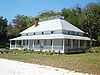
| 1 |
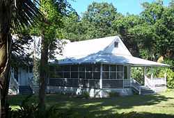
Caldwell Home Place |
|
02003-02-13-0000February 13, 2003
(#03000009) |
160 Curry Street
26°46′01″N 81°26′29″W / 26.766944°N 81.441389°W / 26.766944; -81.441389 (Caldwell Home Place) |
LaBelle |
Part of the LaBelle, FL MPS
|
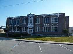
| 2 |
Clewiston Historic Schools |
|
01997-09-26-0000September 26, 1997
(#97001172) |
325 East Circle Drive and 475 East Osceola Avenue
26°45′21″N 80°55′42″W / 26.755833°N 80.928333°W / 26.755833; -80.928333 (Clewiston Historic Schools) |
Clewiston |
|
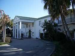
| 3 |
Clewiston Inn |
|
01991-02-21-0000February 21, 1991
(#91000106) |
U.S. Route 27 west of its junction with State Road 832
26°45′35″N 80°56′20″W / 26.759722°N 80.938889°W / 26.759722; -80.938889 (Clewiston Inn) |
Clewiston |
|
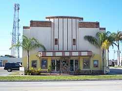
| 4 |
Dixie Crystal Theatre |
|
01998-09-25-0000September 25, 1998
(#98001202) |
100 East Sugarland Highway
26°45′14″N 80°56′04″W / 26.753889°N 80.934444°W / 26.753889; -80.934444 (Dixie Crystal Theatre) |
Clewiston |
|
| 5 |
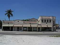
Downtown LaBelle Historic District |
|
01999-03-25-0000March 25, 1999
(#99000371) |
300 block of North Bridge Street
26°45′59″N 81°26′15″W / 26.766389°N 81.4375°W / 26.766389; -81.4375 (Downtown LaBelle Historic District) |
LaBelle |
|
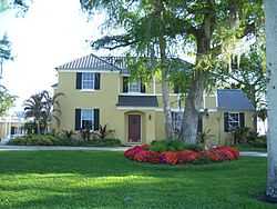
| 6 |
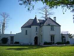
Capt. F. Deane Duff House |
|
01998-01-30-0000January 30, 1998
(#98000025) |
151 West Del Monte Avenue
26°45′41″N 80°56′02″W / 26.761389°N 80.933889°W / 26.761389; -80.933889 (Capt. F. Deane Duff House) |
Clewiston |
|
| 7 |
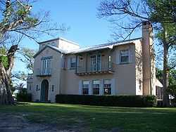
Executive House |
|
01998-02-05-0000February 5, 1998
(#98000059) |
125 West Del Monte Avenue
26°45′44″N 80°55′58″W / 26.762222°N 80.932778°W / 26.762222; -80.932778 (Executive House) |
Clewiston |
|
| 8 |
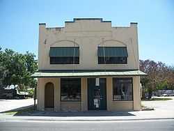
Forrey Building and Annex |
|
01995-07-28-0000July 28, 1995
(#95000914) |
264-282 Bridge Street
26°45′56″N 81°26′16″W / 26.765556°N 81.437778°W / 26.765556; -81.437778 (Forrey Building and Annex) |
LaBelle |
|
| 9 |
Capt. Francis A. Hendry House |
|
01998-02-05-0000February 5, 1998
(#98000061) |
512 Fraser Street
26°45′55″N 81°26′46″W / 26.765278°N 81.446111°W / 26.765278; -81.446111 (Capt. Francis A. Hendry House) |
LaBelle |
|
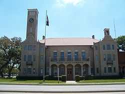
| 10 |
Old Hendry County Courthouse |
|
01990-11-08-0000November 8, 1990
(#90001744) |
Junction of Bridge Street and Hickpochee Avenue
26°45′40″N 81°26′17″W / 26.761111°N 81.438056°W / 26.761111; -81.438056 (Old Hendry County Courthouse) |
LaBelle |
|
| 11 |
Scharnberg House |
|
01999-04-26-0000April 26, 1999
(#99000472) |
325 East Del Monte Avenue
26°45′37″N 80°55′49″W / 26.760278°N 80.930278°W / 26.760278; -80.930278 (Scharnberg House) |
Clewiston |
|
See also
References
- ↑ The latitude and longitude information provided in this table was derived originally from the National Register Information System, which has been found to be fairly accurate for about 99% of listings. For about 1% of NRIS original coordinates, experience has shown that one or both coordinates are typos or otherwise extremely far off; some corrections may have been made. A more subtle problem causes many locations to be off by up to 150 yards, depending on location in the country: most NRIS coordinates were derived from tracing out latitude and longitudes off of USGS topographical quadrant maps created under the North American Datum of 1927, which differs from the current, highly accurate WGS84 GPS system used by most on-line maps. Chicago is about right, but NRIS longitudes in Washington are higher by about 4.5 seconds, and are lower by about 2.0 seconds in Maine. Latitudes differ by about 1.0 second in Florida. Some locations in this table may have been corrected to current GPS standards.
- ↑ "National Register of Historic Places: Weekly List Actions". National Park Service, United States Department of the Interior. Retrieved on May 1, 2015.
- ↑ Numbers represent an ordering by significant words. Various colorings, defined here, differentiate National Historic Landmarks and historic districts from other NRHP buildings, structures, sites or objects.
- ↑ "National Register Information System". National Register of Historic Places. National Park Service. 2009-03-13.
- ↑ The eight-digit number below each date is the number assigned to each location in the National Register Information System database, which can be viewed by clicking the number.
|
|---|
| | Lists by county | | |
|---|
| | Lists by city | |
|---|
| | Other lists | |
|---|
| |
|