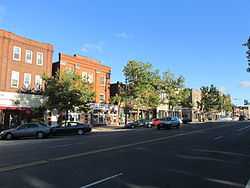
| [3] |
Name on the Register[4] |
Image |
Date listed[5] |
Location |
City or town |
Description |
|---|
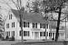
| 1 |
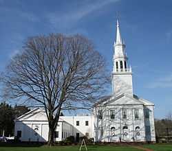
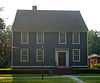
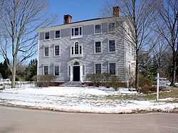
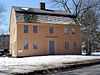
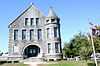
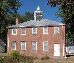
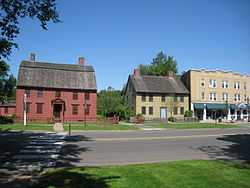
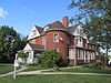
Academy Hall |
|
01977-10-07-0000October 7, 1977
(#77001419) |
785 Old Main St.
41°39′58″N 72°38′20″W / 41.666111°N 72.638889°W / 41.666111; -72.638889 (Academy Hall) |
Rocky Hill |
Built in 1803, a Federal style building which served as a school from 1803 to 1941. It was believed to be one of few original Federal style buildings in Connecticut that had been little altered in its exterior.[6]
|
| 2 |
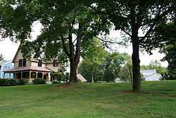
Allen's Cider Mill |
|
01992-04-28-0000April 28, 1992
(#92000389) |
7 Mountain Rd.
41°59′44″N 72°49′56″W / 41.995556°N 72.832222°W / 41.995556; -72.832222 (Allen's Cider Mill) |
Granby |
Built in 1783; one of few surviving wooden cider mills in Connecticut[7]
|
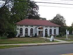
| 3 |
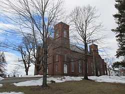
Avon Congregational Church |
|
01972-11-07-0000November 7, 1972
(#72001342) |
Junction of U.S. Routes 44 and 202
41°48′36″N 72°49′52″W / 41.81°N 72.831111°W / 41.81; -72.831111 (Avon Congregational Church) |
Avon |
|
| 4 |
Babb's Beach |
Upload image |
02006-07-12-0000July 12, 2006
(#06000591) |
435 Babbs Rd.
42°01′48″N 72°45′04″W / 42.03°N 72.751111°W / 42.03; -72.751111 (Babb's Beach) |
Suffield |
|
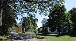
| 5 |
Horace Belden School and Central Grammar School |
|
01993-03-25-0000March 25, 1993
(#93000211) |
933 Hopmeadow St. and 29 Massaco St.
41°52′52″N 72°48′12″W / 41.881111°N 72.803333°W / 41.881111; -72.803333 (Horace Belden School and Central Grammar School) |
Simsbury |
|
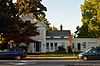
| 6 |
Beleden House |
|
01982-03-15-0000March 15, 1982
(#82004392) |
50 Bellevue Ave.
41°40′31″N 72°56′25″W / 41.675278°N 72.940278°W / 41.675278; -72.940278 (Beleden House) |
Bristol |
|
| 7 |
Makens Bemont House |
Upload image |
01982-03-25-0000March 25, 1982
(#82004397) |
307 Burnside Ave.
41°46′33″N 72°37′31″W / 41.775833°N 72.625278°W / 41.775833; -72.625278 (Makens Bemont House) |
East Hartford |
|
| 8 |
Bigelow-Hartford Carpet Mills Historic District |
|
01994-11-25-0000November 25, 1994
(#94001382) |
Roughly bounded by Lafayette St., Hartford Ave., Alden Ave., and Pleasant, High, Spring, South, and Prospect Sts.
41°59′59″N 72°36′06″W / 41.999722°N 72.601667°W / 41.999722; -72.601667 (Bigelow-Hartford Carpet Mills Historic District) |
Enfield |
|
| 9 |
Bigelow-Hartford Carpet Mills |
Upload image |
01983-03-10-0000March 10, 1983
(#83001256) |
Main and Pleasant Sts.
42°00′01″N 72°36′11″W / 42.000278°N 72.603056°W / 42.000278; -72.603056 (Bigelow-Hartford Carpet Mills) |
Enfield |
|
| 10 |
Selden Brewer House |
Upload image |
01979-06-04-0000June 4, 1979
(#79002631) |
137 High St.
41°44′27″N 72°38′04″W / 41.740833°N 72.634444°W / 41.740833; -72.634444 (Selden Brewer House) |
East Hartford |
|
| 11 |
Bridge No. 455 |
Upload image |
02004-09-29-0000September 29, 2004
(#04001094) |
CT 159 at Stony Brook
41°57′30″N 72°37′40″W / 41.958333°N 72.627778°W / 41.958333; -72.627778 (Bridge No. 455) |
Suffield |
|
| 12 |
Bristol Girls' Club |
|
01987-06-03-0000June 3, 1987
(#87000347) |
47 Upson St.
41°40′07″N 72°56′51″W / 41.668611°N 72.9475°W / 41.668611; -72.9475 (Bristol Girls' Club) |
Bristol |
|
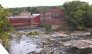
| 13 |
Broad Brook Company |
|
01985-05-02-0000May 2, 1985
(#85000950) |
Main St.
41°54′58″N 72°32′53″W / 41.916111°N 72.548056°W / 41.916111; -72.548056 (Broad Brook Company) |
East Windsor |
|
| 14 |
Brown Tavern |
|
01972-05-05-0000May 5, 1972
(#72001339) |
George Washington Turnpike
41°46′07″N 72°57′57″W / 41.768611°N 72.965833°W / 41.768611; -72.965833 (Brown Tavern) |
Burlington |
|
| 15 |
Bulkeley Bridge |
|
01993-12-10-0000December 10, 1993
(#93001347) |
Interstate 84 over the Connecticut River
41°46′09″N 72°39′58″W / 41.769167°N 72.666111°W / 41.769167; -72.666111 (Bulkeley Bridge) |
East Hartford |
Extends into Hartford
|
| 16 |
Edward L. Burnham Farm |
|
01982-04-12-0000April 12, 1982
(#82004436) |
580 Burnham St.
41°47′59″N 72°34′50″W / 41.799722°N 72.580556°W / 41.799722; -72.580556 (Edward L. Burnham Farm) |
Manchester |
|
| 17 |
Burritt Hotel |
|
01983-07-28-0000July 28, 1983
(#83001257) |
67 W. Main St.
41°40′04″N 72°47′01″W / 41.667778°N 72.783611°W / 41.667778; -72.783611 (Burritt Hotel) |
New Britain |
|
| 18 |
Ernest R. Burwell House |
|
01992-08-18-0000August 18, 1992
(#92001009) |
161 Grove St.
41°40′54″N 72°56′11″W / 41.681667°N 72.936389°W / 41.681667; -72.936389 (Ernest R. Burwell House) |
Bristol |
|
| 19 |
Roger Butler House |
|
01996-08-15-0000August 15, 1996
(#96000847) |
146 Jordan Ln.
41°43′55″N 72°40′18″W / 41.731944°N 72.671667°W / 41.731944; -72.671667 (Roger Butler House) |
Wethersfield |
|
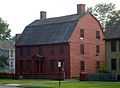
| 20 |
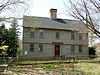
Buttolph-Williams House |
|
01968-11-24-0000November 24, 1968
(#68000048) |
249 Broad St.
41°42′39″N 72°39′04″W / 41.710833°N 72.651111°W / 41.710833; -72.651111 (Buttolph-Williams House) |
Wethersfield |
Exemplifies traditional early New England design.
|
| 21 |
Canton Center Historic District |
|
01997-10-07-0000October 7, 1997
(#97000831) |
Roughly along Barbourtown, E. Mountain, Humphrey, West, and W. Mountain Rds.
41°51′28″N 72°54′58″W / 41.857778°N 72.916111°W / 41.857778; -72.916111 (Canton Center Historic District) |
Canton |
|
| 22 |
Case Brothers Historic District |
|
02009-06-30-0000June 30, 2009
(#09000468) |
680-728 Spring St., 40 Glen Rd., and rough boundaries of Case Mountain Recreation Area and Manchester Land
41°45′46″N 72°29′20″W / 41.762708°N 72.489011°W / 41.762708; -72.489011 (Case Brothers Historic District) |
Manchester |
|
| 23 |
Cedar Hill Cemetery |
|
01997-04-28-0000April 28, 1997
(#97000333) |
453 Fairfield Ave.
41°43′20″N 72°42′12″W / 41.722222°N 72.703333°W / 41.722222; -72.703333 (Cedar Hill Cemetery) |
Newington and Wethersfield |
Extends into Hartford
|
| 24 |
Central Avenue-Center Cemetery Historic District |
|
01993-04-19-0000April 19, 1993
(#93000289) |
Center Ave. from Main St. to Elm St. and Center Cemetery to the north
41°46′09″N 72°38′29″W / 41.769167°N 72.641389°W / 41.769167; -72.641389 (Central Avenue-Center Cemetery Historic District) |
East Hartford |
|
| 25 |
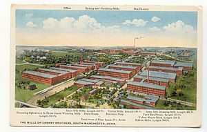
Cheney Brothers Historic District |
|
01978-06-02-0000June 2, 1978
(#78002885) |
Bounded by Hartford Rd. and Laurel, Spruce, and Lampfield Sts.
41°46′00″N 72°31′43″W / 41.766667°N 72.528611°W / 41.766667; -72.528611 (Cheney Brothers Historic District) |
Manchester |
A nineteenth century silk mill and traditional company town.
|
| 26 |
City Hall-Monument District |
|
01973-02-28-0000February 28, 1973
(#73001957) |
W. Main St. and Central Park
41°40′05″N 72°46′59″W / 41.668056°N 72.783056°W / 41.668056; -72.783056 (City Hall-Monument District) |
New Britain |
|
| 27 |
Clark Farm Tenant House Site |
|
02002-01-31-0000January 31, 2002
(#01001554) |
Address Restricted
|
East Granby |
|
| 28 |
Collinsville Historic District |
|
01976-06-23-0000June 23, 1976
(#76001994) |
CT 179
41°48′44″N 72°55′22″W / 41.812222°N 72.922778°W / 41.812222; -72.922778 (Collinsville Historic District) |
Canton |
|
| 29 |
Commercial Trust Company Building |
|
02009-03-17-0000March 17, 2009
(#09000141) |
51–55 West Main Street
41°40′04″N 72°46′59″W / 41.667778°N 72.783056°W / 41.667778; -72.783056 (Commercial Trust Company Building) |
New Britain |
|
| 30 |
Congregational Church of Plainville |
|
02012-06-27-0000June 27, 2012
(#12000358) |
130 W. Main St.
41°40′12″N 72°52′27″W / 41.670075°N 72.87412°W / 41.670075; -72.87412 (Congregational Church of Plainville) |
Plainville |
|
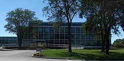
| 31 |
Connecticut General Life Insurance Company Headquarters |
|
02010-01-27-0000January 27, 2010
(#09000324) |
900 Cottage Grove Rd.
41°48′49″N 72°44′42″W / 41.813708°N 72.7449°W / 41.813708; -72.7449 (Connecticut General Life Insurance Company Headquarters) |
Bloomfield |
|
| 32 |
Copper Ledges and Chimney Crest |
Upload image |
01992-08-21-0000August 21, 1992
(#92001010) |
Along Founders Dr. between Bradley and Woodland Sts.
41°40′45″N 72°56′03″W / 41.679167°N 72.934167°W / 41.679167; -72.934167 (Copper Ledges and Chimney Crest) |
Bristol |
|
| 33 |
Frederick H. Cossitt Library |
|
01988-06-22-0000June 22, 1988
(#88000708) |
388 N. Granby Rd.
41°59′45″N 72°49′51″W / 41.995833°N 72.830833°W / 41.995833; -72.830833 (Frederick H. Cossitt Library) |
Granby |
|
| 34 |
Abraham Coult House |
Upload image |
02000-08-11-0000August 11, 2000
(#00000834) |
1695 Hebron Ave.
41°43′08″N 72°32′39″W / 41.718889°N 72.544167°W / 41.718889; -72.544167 (Abraham Coult House) |
Glastonbury |
|
| 35 |
Gen. George Cowles House |
|
01982-05-11-0000May 11, 1982
(#82004400) |
130 Main St.
41°43′03″N 72°50′09″W / 41.7175°N 72.835833°W / 41.7175; -72.835833 (Gen. George Cowles House) |
Farmington |
|
| 36 |
Whitfield Cowles House |
Upload image |
02014-04-08-0000April 8, 2014
(#13000528) |
118 Spoonville Rd.
41°54′05″N 72°44′45″W / 41.901522°N 72.745905°W / 41.901522; -72.745905 (Whitfield Cowles House) |
East Granby |
|
| 37 |
Curtisville Historic District |
Upload image |
01992-12-14-0000December 14, 1992
(#92001638) |
Roughly Pratt St. from Naubuc Ave. to the west of Main St., also Parker Terrace; Parker Terrace extended and adjacent parts of Naubuc
41°43′03″N 72°37′03″W / 41.7175°N 72.6175°W / 41.7175; -72.6175 (Curtisville Historic District) |
Glastonbury |
|
| 38 |
Robert and Julia Darling House |
|
01991-01-03-0000January 3, 1991
(#90002117) |
720 Hopmeadow St.
41°52′20″N 72°48′10″W / 41.872222°N 72.802778°W / 41.872222; -72.802778 (Robert and Julia Darling House) |
Simsbury |
|
| 39 |
Silas Deane House |
|
01970-10-06-0000October 6, 1970
(#70000835) |
203 Main St.
41°41′42″N 72°39′13″W / 41.695°N 72.653611°W / 41.695; -72.653611 (Silas Deane House) |
Wethersfield |
Home of America's first foreign diplomat
|
| 40 |
Downtown Main Street Historic District |
|
01996-12-20-0000December 20, 1996
(#96001464) |
Roughly bounded by Main St., Governor St., Chapman Pl., and Burnside Ave.
41°46′11″N 72°38′38″W / 41.769722°N 72.643889°W / 41.769722; -72.643889 (Downtown Main Street Historic District) |
East Hartford |
|
| 41 |
Drake Hill Road Bridge |
|
01984-07-19-0000July 19, 1984
(#84000999) |
Drake Hill Rd. at the Farmington River
41°52′06″N 72°48′01″W / 41.868333°N 72.800278°W / 41.868333; -72.800278 (Drake Hill Road Bridge) |
Simsbury |
|
| 42 |
East Granby Historic District |
|
01988-08-25-0000August 25, 1988
(#88001318) |
Church and East Sts., Nicholson and Rainbow Rds., N. Main, School and S. Main Sts.
41°56′32″N 72°43′28″W / 41.942222°N 72.724444°W / 41.942222; -72.724444 (East Granby Historic District) |
East Granby |
|
| 43 |
East Weatogue Historic District |
|
01990-07-19-0000July 19, 1990
(#90001107) |
Roughly properties on East Weatogue St. from just north of Riverside Dr. to Hartford Rd., and Folly Farm property to the south
41°50′51″N 72°47′58″W / 41.8475°N 72.799444°W / 41.8475; -72.799444 (East Weatogue Historic District) |
Simsbury |
|
| 44 |
East Windsor Academy |
|
01998-12-03-0000December 3, 1998
(#98000359) |
115 Scantic Rd.
41°54′02″N 72°34′49″W / 41.900556°N 72.580278°W / 41.900556; -72.580278 (East Windsor Academy) |
East Windsor |
|
| 45 |
East Windsor Hill Historic District |
|
01986-05-30-0000May 30, 1986
(#86001208) |
Roughly bounded by the Scantic River, John Fitch Boulevard, Sullivan Ave., and the Connecticut River
41°51′23″N 72°36′45″W / 41.856389°N 72.6125°W / 41.856389; -72.6125 (East Windsor Hill Historic District) |
South Windsor |
|
| 46 |
Elm Street Historic District |
Upload image |
01998-04-13-0000April 13, 1998
(#98000358) |
18-191 Elm St.
41°39′53″N 72°38′40″W / 41.664722°N 72.644444°W / 41.664722; -72.644444 (Elm Street Historic District) |
Rocky Hill |
|
| 47 |
Elmore Houses |
|
01985-08-23-0000August 23, 1985
(#85001832) |
78 and 87 Long Hill Rd.
41°48′10″N 72°35′42″W / 41.802778°N 72.595°W / 41.802778; -72.595 (Elmore Houses) |
South Windsor |
|
| 48 |
Endee Manor Historic District |
Upload image |
01996-02-29-0000February 29, 1996
(#96000027) |
Roughly along Sherman, Mills and Putnam Sts.
41°40′44″N 72°57′28″W / 41.678889°N 72.957778°W / 41.678889; -72.957778 (Endee Manor Historic District) |
Bristol |
|
| 49 |
Enfield Canal |
|
01976-04-22-0000April 22, 1976
(#76001998) |
Along the Connecticut River from Windsor Locks north to Thompsonville
41°57′00″N 72°37′10″W / 41.95°N 72.619444°W / 41.95; -72.619444 (Enfield Canal) |
Windsor Locks |
|
| 50 |
Enfield Historic District |
|
01979-08-10-0000August 10, 1979
(#79002664) |
1106-1492 Enfield St.
41°58′34″N 72°35′37″W / 41.976111°N 72.593611°W / 41.976111; -72.593611 (Enfield Historic District) |
Enfield |
|
| 51 |
Enfield Shakers Historic District |
|
01979-05-21-0000May 21, 1979
(#79002663) |
Shaker, Taylor, and Cybulski Rds.
42°00′42″N 72°30′57″W / 42.011667°N 72.515833°W / 42.011667; -72.515833 (Enfield Shakers Historic District) |
Enfield |
|
| 52 |
Enfield Town Meetinghouse |
Upload image |
01974-09-10-0000September 10, 1974
(#74002050) |
Enfield St. at South Rd.
41°58′16″N 72°35′25″W / 41.971111°N 72.590278°W / 41.971111; -72.590278 (Enfield Town Meetinghouse) |
Enfield |
|
| 53 |
Eno Memorial Hall |
|
01993-04-02-0000April 2, 1993
(#93000210) |
754 Hopmeadow St.
41°52′28″N 72°48′06″W / 41.874444°N 72.801667°W / 41.874444; -72.801667 (Eno Memorial Hall) |
Simsbury |
|
| 54 |
Amos Eno House |
|
01975-04-03-0000April 3, 1975
(#75001935) |
Off U.S. Route 202 on Hopmeadow Rd.
41°52′21″N 72°48′14″W / 41.8725°N 72.803889°W / 41.8725; -72.803889 (Amos Eno House) |
Simsbury |
|
| 55 |
Erwin Home for Worthy and Indigent Women |
|
02002-04-12-0000April 12, 2002
(#02000332) |
140 Bassett St.
41°39′26″N 72°46′48″W / 41.657222°N 72.78°W / 41.657222; -72.78 (Erwin Home for Worthy and Indigent Women) |
New Britain |
|
| 56 |
Farmington Canal-New Haven and Northampton Canal |
|
01985-09-12-0000September 12, 1985
(#85002664) |
Roughly from Suffield in Hartford County to New Haven in New Haven County
41°37′14″N 72°51′54″W / 41.620556°N 72.865°W / 41.620556; -72.865 (Farmington Canal-New Haven and Northampton Canal) |
Avon, East Granby, Farmington, Granby, Plainville, Simsbury, Suffield |
Extends into Southington and New Haven County. First a canal, later a railroad, and now a multi-use trail.
|
| 57 |
Farmington Historic District |
|
01972-03-17-0000March 17, 1972
(#72001331) |
Porter and Mountain Rds., Main and Garden Sts., Hatter's and Hillstead Lanes, and Farmington Ave.
41°43′11″N 72°49′45″W / 41.719722°N 72.829167°W / 41.719722; -72.829167 (Farmington Historic District) |
Farmington |
|
| 58 |
Federal Hill Historic District |
|
01986-08-28-0000August 28, 1986
(#86001989) |
Roughly bounded by Summer, Maple, Woodland, Goodwin, and High Sts.
41°40′35″N 72°56′27″W / 41.676389°N 72.940833°W / 41.676389; -72.940833 (Federal Hill Historic District) |
Bristol |
|
| 59 |
Capt. Oliver Filley House |
|
02007-05-15-0000May 15, 2007
(#07000420) |
130 Mountain Ave.
41°50′05″N 72°45′44″W / 41.8347°N 72.7623°W / 41.8347; -72.7623 (Capt. Oliver Filley House) |
Bloomfield |
|
| 60 |
First Church of Christ |
|
01975-05-15-0000May 15, 1975
(#75002056) |
75 Main St.
41°43′14″N 72°49′47″W / 41.720556°N 72.829722°W / 41.720556; -72.829722 (First Church of Christ) |
Farmington |
Church of the Amistad freed slaves.
|
| 61 |
First Congregational Church of East Hartford and Parsonage |
|
01982-03-25-0000March 25, 1982
(#82004398) |
829-837 Main St.
41°46′08″N 72°38′41″W / 41.768889°N 72.644722°W / 41.768889; -72.644722 (First Congregational Church of East Hartford and Parsonage) |
East Hartford |
|
| 62 |
First Lutheran Church of the Reformation |
|
02010-08-30-0000August 30, 2010
(#10000825) |
77 Franklin Square
41°39′46″N 72°46′50″W / 41.662778°N 72.780556°W / 41.662778; -72.780556 (First Lutheran Church of the Reformation) |
New Britain |
|
| 63 |
Forestville Passenger Station |
|
01978-04-19-0000April 19, 1978
(#78002862) |
171 Central St.
41°40′24″N 72°53′54″W / 41.673333°N 72.898333°W / 41.673333; -72.898333 (Forestville Passenger Station) |
Bristol |
|
| 64 |
John Fuller House |
Upload image |
01982-03-15-0000March 15, 1982
(#82004439) |
463 Halliday Ave.
42°00′58″N 72°39′23″W / 42.016111°N 72.656389°W / 42.016111; -72.656389 (John Fuller House) |
Suffield |
|
| 65 |
Garvan-Carroll Historic District |
Upload image |
01991-08-26-0000August 26, 1991
(#91001049) |
Roughly bounded by S. Prospect, Chapel and Main Sts., and Interstate 84
41°46′01″N 72°38′52″W / 41.766944°N 72.647778°W / 41.766944; -72.647778 (Garvan-Carroll Historic District) |
East Hartford |
|
| 66 |
Francis Gillette House |
|
01982-03-25-0000March 25, 1982
(#82004391) |
559 Bloomfield Ave.
41°48′50″N 72°44′23″W / 41.813889°N 72.739722°W / 41.813889; -72.739722 (Francis Gillette House) |
Bloomfield |
|
| 67 |
Gilman-Hayden House |
|
01984-08-16-0000August 16, 1984
(#84001007) |
1871 Main St.
41°47′31″N 72°38′46″W / 41.791944°N 72.646111°W / 41.791944; -72.646111 (Gilman-Hayden House) |
East Hartford |
|
| 68 |
Glastonbury Historic District |
|
01984-08-02-0000August 2, 1984
(#84001011) |
Roughly Main St. from Hebron Ave. to Talcott Rd.
41°42′09″N 72°36′34″W / 41.7025°N 72.609444°W / 41.7025; -72.609444 (Glastonbury Historic District) |
Glastonbury |
|
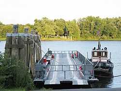
| 69 |
Glastonbury-Rocky Hill Ferry Historic District |
|
02005-09-21-0000September 21, 2005
(#05001046) |
Roughly along Tryon St., Ferry Ln. and Glastonbury Ave., Meadow and Riverview Rds.
41°39′46″N 72°37′19″W / 41.662778°N 72.621944°W / 41.662778; -72.621944 (Glastonbury-Rocky Hill Ferry Historic District) |
Glastonbury |
|
| 70 |
Gothic Cottage |
Upload image |
01982-02-25-0000February 25, 1982
(#82004441) |
1425 Mapleton Ave.
42°01′04″N 72°37′17″W / 42.017778°N 72.621389°W / 42.017778; -72.621389 (Gothic Cottage) |
Suffield |
|
| 71 |
Granby Center Historic District |
|
01985-10-17-0000October 17, 1985
(#85003149) |
3-8 E. Granby Rd., 2 Park Pl., and 207-265 Salmon Brook St. S
41°57′00″N 72°47′33″W / 41.95°N 72.7925°W / 41.95; -72.7925 (Granby Center Historic District) |
Granby |
|
| 72 |
Ebenezer Grant House |
|
01977-09-19-0000September 19, 1977
(#77001408) |
1653 Main St.
41°51′05″N 72°36′31″W / 41.851389°N 72.608611°W / 41.851389; -72.608611 (Ebenezer Grant House) |
South Windsor |
|
| 73 |
Gridley-Parsons-Staples Homestead |
Upload image |
01981-07-30-0000July 30, 1981
(#81000537) |
1554 Farmington Ave.
41°45′01″N 72°56′29″W / 41.750278°N 72.941389°W / 41.750278; -72.941389 (Gridley-Parsons-Staples Homestead) |
Farmington |
|
| 74 |
Dr. Elizur Hale House |
|
01989-11-13-0000November 13, 1989
(#89001088) |
3181 Hebron Ave.
41°42′29″N 72°28′44″W / 41.708056°N 72.478889°W / 41.708056; -72.478889 (Dr. Elizur Hale House) |
Glastonbury |
|
| 75 |
Hart's Corner Historic District |
Upload image |
01987-07-08-0000July 8, 1987
(#87000351) |
247 Monce Rd. and 102 and 105 Stafford Rd.
41°43′41″N 72°54′50″W / 41.728056°N 72.913889°W / 41.728056; -72.913889 (Hart's Corner Historic District) |
Burlington |
|
| 76 |
Hastings Hill Historic District |
Upload image |
01979-09-14-0000September 14, 1979
(#79002669) |
987-1308 Hill St., 1242 Spruce St., and 1085-1162 Russell Ave.
42°00′35″N 72°40′38″W / 42.009722°N 72.677222°W / 42.009722; -72.677222 (Hastings Hill Historic District) |
Suffield |
|
| 77 |
Hatheway House |
|
01975-08-06-0000August 6, 1975
(#75001934) |
55 S. Main St.
41°58′48″N 72°39′10″W / 41.98°N 72.652778°W / 41.98; -72.652778 (Hatheway House) |
Suffield |
|
| 78 |
Samuel Hayes II House |
Upload image |
01992-04-27-0000April 27, 1992
(#92000390) |
67 Barndoor Hills Rd.
41°56′42″N 72°49′06″W / 41.945°N 72.818333°W / 41.945; -72.818333 (Samuel Hayes II House) |
Granby |
|
| 79 |
Hazardville Historic District |
|
01980-02-19-0000February 19, 1980
(#80004061) |
Hazardville (near CT 190 and CT 192)
41°58′33″N 72°31′54″W / 41.975833°N 72.531667°W / 41.975833; -72.531667 (Hazardville Historic District) |
Enfield |
|
| 80 |
Heublein Tower |
|
01983-06-30-0000June 30, 1983
(#83001260) |
Talcott Mountain State Park
41°49′25″N 72°47′51″W / 41.823611°N 72.7975°W / 41.823611; -72.7975 (Heublein Tower) |
Simsbury |
|
| 81 |
Hill-Stead |
|
01991-07-17-0000July 17, 1991
(#91002056) |
35 Mountain Rd.
41°43′13″N 72°49′09″W / 41.720278°N 72.819167°W / 41.720278; -72.819167 (Hill-Stead) |
Farmington |
Colonial revival house and art museum located in the Farmington Historic District
|
| 82 |
Hilltop Farm |
Upload image |
02005-01-12-0000January 12, 2005
(#04001463) |
1550-1760 Mapleton Ave.
42°01′30″N 72°36′50″W / 42.025°N 72.613889°W / 42.025; -72.613889 (Hilltop Farm) |
Suffield |
|
| 83 |
Hitchcock-Schwarzmann Mill |
Upload image |
01977-09-13-0000September 13, 1977
(#77001409) |
North of Burlington at Foote and Vineyard Rds.
41°46′54″N 72°57′42″W / 41.781667°N 72.961667°W / 41.781667; -72.961667 (Hitchcock-Schwarzmann Mill) |
Burlington |
|
| 84 |
Judah Holcomb House |
|
01988-06-16-0000June 16, 1988
(#88000755) |
257 N. Granby Rd.
41°58′50″N 72°49′08″W / 41.980556°N 72.818889°W / 41.980556; -72.818889 (Judah Holcomb House) |
Granby |
|
| 85 |
Nathaniel Holcomb III House |
|
01982-04-29-0000April 29, 1982
(#82004486) |
45 Bushy Hill Rd.
41°57′00″N 72°48′40″W / 41.95°N 72.811111°W / 41.95; -72.811111 (Nathaniel Holcomb III House) |
Granby |
|
| 86 |
John Hollister House |
|
01972-11-07-0000November 7, 1972
(#72001329) |
14 Tryon St.
41°40′01″N 72°36′32″W / 41.666944°N 72.608889°W / 41.666944; -72.608889 (John Hollister House) |
Glastonbury |
|
| 87 |
Francis H. Holmes House |
Upload image |
01984-06-28-0000June 28, 1984
(#84001014) |
349 Rocky Hill Ave.
41°39′14″N 72°45′34″W / 41.653889°N 72.759444°W / 41.653889; -72.759444 (Francis H. Holmes House) |
New Britain |
|
| 88 |
Henry Hooker House |
|
01978-11-29-0000November 29, 1978
(#78002867) |
111 High Rd.
41°38′41″N 72°47′22″W / 41.644722°N 72.789444°W / 41.644722; -72.789444 (Henry Hooker House) |
Berlin |
|
| 89 |
John Humphrey House |
|
01990-11-15-0000November 15, 1990
(#90001755) |
115 E. Weatogue St.
41°51′48″N 72°47′43″W / 41.863333°N 72.795278°W / 41.863333; -72.795278 (John Humphrey House) |
Simsbury |
|
| 90 |
William I Jerome House |
|
01987-06-02-0000June 2, 1987
(#87000792) |
367 Jerome Ave.
41°41′59″N 72°55′46″W / 41.699722°N 72.929444°W / 41.699722; -72.929444 (William I Jerome House) |
Bristol |
|
| 91 |
Gen. Martin Kellogg House |
|
01987-10-01-0000October 1, 1987
(#87001770) |
679 Willard Ave.
41°44′21″N 72°40′58″W / 41.739167°N 72.682778°W / 41.739167; -72.682778 (Gen. Martin Kellogg House) |
Newington |
The home of General Martin Kellog III, also known as the Kellogg-Eddy House
|
| 92 |
Enoch Kelsey House |
|
01982-06-28-0000June 28, 1982
(#82004437) |
1702 Main St.
41°41′05″N 72°43′27″W / 41.684722°N 72.724167°W / 41.684722; -72.724167 (Enoch Kelsey House) |
Newington |
|
| 93 |
Ezekiel Kelsey House |
|
01977-09-16-0000September 16, 1977
(#77001410) |
429 Beckley Rd.
41°37′43″N 72°43′24″W / 41.628611°N 72.723333°W / 41.628611; -72.723333 (Ezekiel Kelsey House) |
Berlin |
|
| 94 |
Kensington Grammar School-Jean E. Hooker High School |
Upload image |
02012-06-27-0000June 27, 2012
(#12000360) |
462 Alling St.
41°38′02″N 72°46′15″W / 41.63392°N 72.770909°W / 41.63392; -72.770909 (Kensington Grammar School-Jean E. Hooker High School) |
Berlin |
|
| 95 |
Kensington Soldier's Monument |
|
02013-07-03-0000July 3, 2013
(#13000456) |
312 Percival Avenue
41°37′22″N 72°46′59″W / 41.62288°N 72.78298°W / 41.62288; -72.78298 (Kensington Soldier's Monument) |
Berlin |
|
| 96 |
Kimberly Mansion |
|
01974-09-17-0000September 17, 1974
(#74002178) |
1625 Main St.
41°41′22″N 72°36′26″W / 41.689444°N 72.607222°W / 41.689444; -72.607222 (Kimberly Mansion) |
Glastonbury |
Home of Abby and Julia Evelina Smith, suffragists who fought the town of Glastonbury and won.
|
| 97 |
King's Field House |
Upload image |
01982-03-11-0000March 11, 1982
(#82004440) |
827 North St.
42°00′26″N 72°38′42″W / 42.007222°N 72.645°W / 42.007222; -72.645 (King's Field House) |
Suffield |
|
| 98 |
Alexander King House |
|
01976-04-26-0000April 26, 1976
(#76001993) |
232 S. Main St.
41°58′31″N 72°39′12″W / 41.975278°N 72.653333°W / 41.975278; -72.653333 (Alexander King House) |
Suffield |
|
| 99 |
Lewis-Zukowski House |
Upload image |
01990-02-21-0000February 21, 1990
(#90000147) |
1095 S. Grand St.
41°57′41″N 72°42′41″W / 41.961389°N 72.711389°W / 41.961389; -72.711389 (Lewis-Zukowski House) |
Suffield |
|
| 100 |
Main Street Historic District |
|
01995-08-15-0000August 15, 1995
(#95001006) |
Roughly Main St. from School St. to Summer St. and adjacent areas of Prospect St.
41°40′19″N 72°56′35″W / 41.671944°N 72.943056°W / 41.671944; -72.943056 (Main Street Historic District) |
Bristol |
|
| 101 |
Main Street Historic District |
|
01996-04-18-0000April 18, 1996
(#96000428) |
Roughly Main St. from Center St. to Eldridge St.
41°46′16″N 72°31′18″W / 41.771111°N 72.521667°W / 41.771111; -72.521667 (Main Street Historic District) |
Manchester |
|
| 102 |
Manchester Historic District |
|
02000-08-02-0000August 2, 2000
(#00000857) |
Roughly bounded by Center Spring Park, Main St., Interstate 384, and Campfield Rd.
41°46′12″N 72°31′42″W / 41.77°N 72.528333°W / 41.77; -72.528333 (Manchester Historic District) |
Manchester |
|
| 103 |
Marlborough Congregational Church |
|
01993-12-10-0000December 10, 1993
(#93001346) |
35 S. Main St.
41°37′44″N 72°27′19″W / 41.628889°N 72.455278°W / 41.628889; -72.455278 (Marlborough Congregational Church) |
Marlborough |
|
| 104 |
Marlborough House |
|
01993-09-02-0000September 2, 1993
(#93000906) |
226 Grove St.
41°40′52″N 72°56′02″W / 41.681111°N 72.933889°W / 41.681111; -72.933889 (Marlborough House) |
Bristol |
|
| 105 |
Marlborough Tavern |
|
01978-12-06-0000December 6, 1978
(#78002866) |
Off CT 66
41°37′52″N 72°27′35″W / 41.631111°N 72.459722°W / 41.631111; -72.459722 (Marlborough Tavern) |
Marlborough |
|
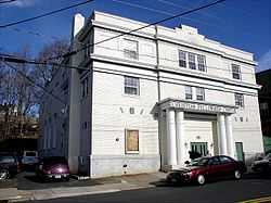
| 106 |
Masonic Temple |
|
01995-07-21-0000July 21, 1995
(#95000864) |
265 W. Main St.
41°39′57″N 72°47′27″W / 41.665833°N 72.790833°W / 41.665833; -72.790833 (Masonic Temple) |
New Britain |
|
| 107 |
Massacoe Forest Pavilion |
|
01986-09-04-0000September 4, 1986
(#86001731) |
Off Old Farms Rd., Stratton Brook State Park
41°51′49″N 72°50′10″W / 41.863611°N 72.836111°W / 41.863611; -72.836111 (Massacoe Forest Pavilion) |
Simsbury |
|
| 108 |
Melrose |
Upload image |
02010-08-26-0000August 26, 2010
(#10000577) |
Broad Brook Rd. and Melrose Rd.
41°56′15″N 72°31′38″W / 41.9375°N 72.527222°W / 41.9375; -72.527222 (Melrose) |
East Windsor |
|
| 109 |
Melrose Road Bridge |
Upload image |
01999-08-05-0000August 5, 1999
(#99000922) |
Melrose Rd. over the Scantic River
41°56′18″N 72°32′51″W / 41.938333°N 72.5475°W / 41.938333; -72.5475 (Melrose Road Bridge) |
East Windsor |
|
| 110 |
Memorial Hall |
|
01987-06-02-0000June 2, 1987
(#87000802) |
Junction of S. Main and Elm Sts.
41°55′19″N 72°37′41″W / 41.921944°N 72.628056°W / 41.921944; -72.628056 (Memorial Hall) |
Windsor Locks |
|
| 111 |
Naubuc Avenue-Broad Street Historic District |
Upload image |
01998-12-04-0000December 4, 1998
(#98001439) |
Roughly along Broad St. and Naubuc Ave.
41°43′48″N 72°37′38″W / 41.73°N 72.627222°W / 41.73; -72.627222 (Naubuc Avenue-Broad Street Historic District) |
East Hartford |
|
| 112 |
New Britain Opera House |
Upload image |
01977-10-07-0000October 7, 1977
(#77001421) |
466-468 Main St.
41°40′14″N 72°46′55″W / 41.670556°N 72.781944°W / 41.670556; -72.781944 (New Britain Opera House) |
New Britain |
|
| 113 |
New Britain Public High School Campus |
Upload image |
02015-03-23-0000March 23, 2015
(#15000101) |
50 Bassett & 161 S. Main Sts.
41°39′38″N 72°46′48″W / 41.6606°N 72.7801°W / 41.6606; -72.7801 (New Britain Public High School Campus) |
New Britain |
Converted to residences.
|
| 114 |
New Haven District Campground |
Upload image |
01980-05-19-0000May 19, 1980
(#80004065) |
Off CT 177
41°41′10″N 72°53′23″W / 41.686111°N 72.889722°W / 41.686111; -72.889722 (New Haven District Campground) |
Plainville |
|
| 115 |
Newington Junction North Historic District |
|
01987-06-02-0000June 2, 1987
(#86003465) |
55-108 Willard Ave.
41°43′05″N 72°44′15″W / 41.718056°N 72.7375°W / 41.718056; -72.7375 (Newington Junction North Historic District) |
Newington |
|
| 116 |
Newington Junction Railroad Depot |
|
01986-12-22-0000December 22, 1986
(#86003478) |
160 Willard and 200 Francis Aves.
41°42′55″N 72°44′13″W / 41.715278°N 72.736944°W / 41.715278; -72.736944 (Newington Junction Railroad Depot) |
Newington |
|
| 117 |
Newington Junction South Historic District |
|
01987-06-02-0000June 2, 1987
(#86003462) |
268-319 Willard Ave.
41°42′41″N 72°44′15″W / 41.711389°N 72.7375°W / 41.711389; -72.7375 (Newington Junction South Historic District) |
Newington |
|
| 118 |
Newington Junction West Historic District |
Upload image |
01987-06-02-0000June 2, 1987
(#86003464) |
175 and 181-183 Willard Ave. and 269-303 W. Hill Rd.
41°42′54″N 72°44′21″W / 41.715°N 72.739167°W / 41.715; -72.739167 (Newington Junction West Historic District) |
Newington |
|
| 119 |
Charles H. Norton House |
|
01976-05-11-0000May 11, 1976
(#76002139) |
132 Redstone Hill
41°39′32″N 72°53′06″W / 41.658889°N 72.885°W / 41.658889; -72.885 (Charles H. Norton House) |
Plainville |
Home of the inventor of precision grinding equipment.
|
| 120 |
Old Farm Schoolhouse |
|
01972-10-18-0000October 18, 1972
(#72001340) |
Junction of Park Ave. and School St.
41°49′25″N 72°42′32″W / 41.823611°N 72.708889°W / 41.823611; -72.708889 (Old Farm Schoolhouse) |
Bloomfield |
|
| 121 |
Old Newgate Prison |
|
01970-10-15-0000October 15, 1970
(#70000839) |
Newgate Rd.
41°57′43″N 72°44′44″W / 41.961944°N 72.745556°W / 41.961944; -72.745556 (Old Newgate Prison) |
East Granby |
Colonial prison; loyalists were held here during the American Revolutionary War
|
| 122 |
Old Wethersfield Historic District |
|
01970-12-29-0000December 29, 1970
(#70000719) |
Bounded by Hartford, railroad tracks, Interstate 91, and Rocky Hill
41°42′32″N 72°39′23″W / 41.708889°N 72.656389°W / 41.708889; -72.656389 (Old Wethersfield Historic District) |
Wethersfield |
|
| 123 |
Pequabuck Bridge |
|
01984-07-19-0000July 19, 1984
(#84001049) |
Meadow Rd. at the Pequabuck River
41°42′59″N 72°50′25″W / 41.716389°N 72.840278°W / 41.716389; -72.840278 (Pequabuck Bridge) |
Farmington |
|
| 124 |
Capt. Elisha Phelps House |
|
01972-09-22-0000September 22, 1972
(#72001345) |
800 Hopmeadow St.
41°52′34″N 72°48′05″W / 41.876111°N 72.801389°W / 41.876111; -72.801389 (Capt. Elisha Phelps House) |
Simsbury |
|
| 125 |
Ezekiel Phelps House |
|
01982-02-25-0000February 25, 1982
(#82004396) |
38 Holcomb St.
41°56′36″N 72°44′47″W / 41.943333°N 72.746389°W / 41.943333; -72.746389 (Ezekiel Phelps House) |
East Granby |
|
| 126 |
Pine Grove Historic District |
|
01980-02-11-0000February 11, 1980
(#80004066) |
CT 167
41°46′09″N 72°51′25″W / 41.769167°N 72.856944°W / 41.769167; -72.856944 (Pine Grove Historic District) |
Avon |
|
| 127 |
David Pinney House and Barn |
Upload image |
01977-07-25-0000July 25, 1977
(#77001415) |
58 West St.
41°55′57″N 72°38′24″W / 41.9325°N 72.64°W / 41.9325; -72.64 (David Pinney House and Barn) |
Windsor Locks |
|
| 128 |
Pitkin Glassworks Ruin |
|
01979-04-09-0000April 9, 1979
(#79002628) |
corner of Putnam and Parker Streets
41°46′36″N 72°30′15″W / 41.776593°N 72.504126°W / 41.776593; -72.504126 (Pitkin Glassworks Ruin) |
Manchester |
|
| 129 |
John Robbins House |
|
01988-09-20-0000September 20, 1988
(#88001526) |
262 Old Main St.
41°40′56″N 72°39′05″W / 41.682222°N 72.651389°W / 41.682222; -72.651389 (John Robbins House) |
Rocky Hill |
|
| 130 |
Unni Robbins II House |
|
02005-09-21-0000September 21, 2005
(#05001049) |
1692 Main St.
41°41′12″N 72°43′19″W / 41.686667°N 72.721944°W / 41.686667; -72.721944 (Unni Robbins II House) |
Newington |
|
| 131 |
Rockwell Park |
|
01987-05-21-0000May 21, 1987
(#87000788) |
Dutton Ave. and Jacobs St.
41°40′27″N 72°59′01″W / 41.674167°N 72.983611°W / 41.674167; -72.983611 (Rockwell Park) |
Bristol |
|
| 132 |
Rocky Hill Center Historic District |
Upload image |
02007-03-09-0000March 9, 2007
(#07000111) |
Roughly bounded by Old Main, Pratt, and Washington Sts., Glastonbury Ave., and Riverview Rd.
41°39′54″N 72°38′06″W / 41.664947°N 72.634933°W / 41.664947; -72.634933 (Rocky Hill Center Historic District) |
Rocky Hill |
|
| 133 |
Rocky Hill Congregational Church |
|
01982-05-07-0000May 7, 1982
(#82004438) |
805-817 Old Main St.
41°39′56″N 72°38′21″W / 41.665556°N 72.639167°W / 41.665556; -72.639167 (Rocky Hill Congregational Church) |
Rocky Hill |
|
| 134 |
Rowe and Weed Houses |
|
01978-01-18-0000January 18, 1978
(#78002860) |
208 Salmon Brook St.
41°56′45″N 72°47′27″W / 41.945833°N 72.790833°W / 41.945833; -72.790833 (Rowe and Weed Houses) |
Granby |
|
| 135 |
St. John's Episcopal Church |
|
01983-11-28-0000November 28, 1983
(#83003567) |
1160 Main St.
41°46′25″N 72°38′27″W / 41.773611°N 72.640833°W / 41.773611; -72.640833 (St. John's Episcopal Church) |
East Hartford |
|
| 136 |
St. John's Episcopal Church |
|
01982-04-27-0000April 27, 1982
(#82004442) |
92 Main St.
41°55′43″N 72°37′06″W / 41.928611°N 72.618333°W / 41.928611; -72.618333 (St. John's Episcopal Church) |
East Windsor |
|
| 137 |
St. Mary's Parochial School |
|
01991-04-03-0000April 3, 1991
(#91000364) |
Beaver St. south of Broad St.
41°40′18″N 72°46′58″W / 41.671667°N 72.782778°W / 41.671667; -72.782778 (St. Mary's Parochial School) |
New Britain |
|
| 138 |
Shade Swamp Shelter |
Upload image |
01986-09-04-0000September 4, 1986
(#86001746) |
U.S. Route 6 east of New Britain Ave.
41°42′15″N 72°51′35″W / 41.704167°N 72.859722°W / 41.704167; -72.859722 (Shade Swamp Shelter) |
Farmington |
|
| 139 |
Simeon North Factory Site |
|
01990-08-18-0000August 18, 1990
(#90001158) |
Address Restricted
|
Berlin |
|
| 140 |
Simsbury Bank and Trust Company Building |
Upload image |
01986-11-20-0000November 20, 1986
(#86003323) |
760-762 Hopmeadow St.
41°52′31″N 72°48′06″W / 41.875278°N 72.801667°W / 41.875278; -72.801667 (Simsbury Bank and Trust Company Building) |
Simsbury |
|
| 141 |
Simsbury Center Historic District |
|
01996-04-12-0000April 12, 1996
(#96000356) |
Roughly Hopmeadow St. from West St. to Massaco St.
41°52′31″N 72°48′11″W / 41.875278°N 72.803056°W / 41.875278; -72.803056 (Simsbury Center Historic District) |
Simsbury |
|
| 142 |
Simsbury Railroad Depot |
|
01976-03-26-0000March 26, 1976
(#76001997) |
Railroad Ave. at Station St.
41°52′27″N 72°48′02″W / 41.874167°N 72.800556°W / 41.874167; -72.800556 (Simsbury Railroad Depot) |
Simsbury |
|
| 143 |
Simsbury Townhouse |
|
01993-04-02-0000April 2, 1993
(#93000209) |
695 Hopmeadow St.
41°52′18″N 72°48′17″W / 41.871667°N 72.804722°W / 41.871667; -72.804722 (Simsbury Townhouse) |
Simsbury |
|
| 144 |
Sloper-Wesoly House |
|
01999-01-07-0000January 7, 1999
(#98001577) |
27 Grove Hill St.
41°40′00″N 72°47′30″W / 41.666667°N 72.791667°W / 41.666667; -72.791667 (Sloper-Wesoly House) |
New Britain |
|
| 145 |
South Congregational Church |
|
01990-04-06-0000April 6, 1990
(#89000930) |
90 Main St.
41°39′54″N 72°46′56″W / 41.665°N 72.782222°W / 41.665; -72.782222 (South Congregational Church) |
New Britain |
|
| 146 |
South End Historic District |
Upload image |
02001-01-19-0000January 19, 2001
(#00001625) |
Roughly bounded by East Rd., Willis St., George St., and South St.
41°39′55″N 72°56′33″W / 41.665278°N 72.9425°W / 41.665278; -72.9425 (South End Historic District) |
Bristol |
|
| 147 |
South Glastonbury Historic District |
|
01984-11-23-0000November 23, 1984
(#84000250) |
High, Hopewell, Main, and Water Sts.; also 999-1417 and 1032-1420 Main St., 6 and 7 Chestnut Hill Rd.
41°39′59″N 72°36′15″W / 41.666389°N 72.604167°W / 41.666389; -72.604167 (South Glastonbury Historic District) |
Glastonbury |
Second set of boundaries represent a boundary increase of 02009-09-24-0000September 24, 2009
|
| 148 |
Southwest District School |
|
01992-07-24-0000July 24, 1992
(#92000904) |
430 Simsbury Rd.
41°49′04″N 72°46′02″W / 41.817778°N 72.767222°W / 41.817778; -72.767222 (Southwest District School) |
Bloomfield |
|
| 149 |
Stanley-Whitman House |
|
01966-10-15-0000October 15, 1966
(#66000882) |
37 High St.
41°43′16″N 72°49′32″W / 41.721111°N 72.825556°W / 41.721111; -72.825556 (Stanley-Whitman House) |
Farmington |
Classic seventeenth-century New England saltbox.
|
| 150 |
Suffield Historic District |
|
01979-09-25-0000September 25, 1979
(#79003750) |
Runs along N. and S. Main St.
41°58′51″N 72°39′06″W / 41.980833°N 72.651667°W / 41.980833; -72.651667 (Suffield Historic District) |
Suffield |
|
| 151 |
Tariffville Historic District |
|
01993-04-02-0000April 2, 1993
(#93000173) |
Roughly bounded by Winthrop St., Main St., Mountain Rd., Laurel Hill Rd., and Elm St.
41°54′36″N 72°45′53″W / 41.91°N 72.764722°W / 41.91; -72.764722 (Tariffville Historic District) |
Simsbury |
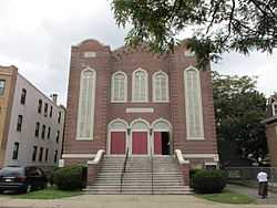
|
| 152 |
Tephereth Israel Synagogue |
|
01995-05-11-0000May 11, 1995
(#95000576) |
76 Winter St.
41°40′19″N 72°46′44″W / 41.671944°N 72.778889°W / 41.671944; -72.778889 (Tephereth Israel Synagogue) |
New Britain |
|
| 153 |
Terry's Plain Historic District |
|
01993-12-10-0000December 10, 1993
(#93001417) |
Roughly bounded by Pharos, Quarry, and Terry's Plain Rds., and the Farmington River
41°53′01″N 72°47′05″W / 41.883611°N 72.784722°W / 41.883611; -72.784722 (Terry's Plain Historic District) |
Simsbury |
|
| 154 |
Terry-Hayden House |
Upload image |
01982-03-25-0000March 25, 1982
(#82004393) |
125 Middle St.
41°39′57″N 72°55′17″W / 41.665833°N 72.921389°W / 41.665833; -72.921389 (Terry-Hayden House) |
Bristol |
|
| 155 |
William H. Thompson Farmstead |
Upload image |
02003-04-18-0000April 18, 2003
(#03000234) |
215 and 219 Melrose Rd.
41°56′16″N 72°31′22″W / 41.937778°N 72.522778°W / 41.937778; -72.522778 (William H. Thompson Farmstead) |
East Windsor |
|
| 156 |
Town Bridge |
|
01999-08-05-0000August 5, 1999
(#99000923) |
Town Bridge over the Farmington River
41°49′28″N 72°55′43″W / 41.824444°N 72.928611°W / 41.824444; -72.928611 (Town Bridge) |
Canton |
|
| 157 |
Townsend G. Treadway House |
|
01991-12-19-0000December 19, 1991
(#91001871) |
100 Oakland St.
41°40′51″N 72°56′10″W / 41.680833°N 72.936111°W / 41.680833; -72.936111 (Townsend G. Treadway House) |
Bristol |
|
| 158 |
Treadwell House |
Upload image |
01982-04-27-0000April 27, 1982
(#82004395) |
George Washington Turnpike
41°46′10″N 72°59′21″W / 41.769444°N 72.989167°W / 41.769444; -72.989167 (Treadwell House) |
Burlington |
|
| 159 |
Trinity Methodist Episcopal Church |
|
02007-07-21-0000July 21, 2007
(#07000697) |
69 Main St.
41°40′02″N 72°46′51″W / 41.667222°N 72.780833°W / 41.667222; -72.780833 (Trinity Methodist Episcopal Church) |
New Britain |
|
| 160 |
Tunxis Forest Headquarters House |
Upload image |
01986-09-04-0000September 4, 1986
(#86001759) |
Western side of Pell Rd. 0.2 miles (0.32 km) north of Town Rd.
42°00′13″N 72°54′43″W / 42.003611°N 72.911944°W / 42.003611; -72.911944 (Tunxis Forest Headquarters House) |
Hartland |
|
| 161 |
Tunxis Forest Ski Cabin |
Upload image |
01986-09-05-0000September 5, 1986
(#86001761) |
Western end of Balance Rock Rd.
42°00′32″N 72°55′47″W / 42.008889°N 72.929722°W / 42.008889; -72.929722 (Tunxis Forest Ski Cabin) |
Hartland |
|
| 162 |
Tunxis Hose Firehouse |
|
01983-07-28-0000July 28, 1983
(#83001266) |
Lovely St. and Farmington Ave.
41°45′31″N 72°53′14″W / 41.758611°N 72.887222°W / 41.758611; -72.887222 (Tunxis Hose Firehouse) |
Farmington |
|
| 163 |
Union Village Historic District |
Upload image |
02002-08-06-0000August 6, 2002
(#02000831) |
Roughly bounded by Union Pond, Oakland St., railroad right-of-way, Marble St., and the Hockanum River
41°47′47″N 72°31′43″W / 41.796389°N 72.528611°W / 41.796389; -72.528611 (Union Village Historic District) |
Manchester |
|
| 164 |
US Post Office-Manchester Main |
|
01986-01-21-0000January 21, 1986
(#86000127) |
479 Main St. at Center St.
41°46′35″N 72°31′21″W / 41.776389°N 72.5225°W / 41.776389; -72.5225 (US Post Office-Manchester Main) |
Manchester |
|
| 165 |
Viets' Tavern |
|
01972-02-23-0000February 23, 1972
(#72001338) |
Newgate Rd.
41°57′43″N 72°44′42″W / 41.961944°N 72.745°W / 41.961944; -72.745 (Viets' Tavern) |
East Granby |
|
| 166 |
Walnut Hill District |
|
01975-09-02-0000September 2, 1975
(#75001936) |
Irregular pattern roughly bounded by Winthrup, Arch, and Lake Sts., and Walnut Hill Park
41°39′50″N 72°47′09″W / 41.663889°N 72.785833°W / 41.663889; -72.785833 (Walnut Hill District) |
New Britain |
|
| 167 |
Walnut Hill Park |
|
01982-11-30-0000November 30, 1982
(#82001000) |
W. Main St.
41°39′43″N 72°47′31″W / 41.661944°N 72.791944°W / 41.661944; -72.791944 (Walnut Hill Park) |
New Britain |
|
| 168 |
Washington School |
|
01984-07-19-0000July 19, 1984
(#84001053) |
High and Carmody Sts.
41°40′40″N 72°47′18″W / 41.677778°N 72.788333°W / 41.677778; -72.788333 (Washington School) |
New Britain |
|
| 169 |
Joseph Webb House |
|
01966-10-15-0000October 15, 1966
(#66000885) |
211 Main St.
41°42′42″N 72°39′13″W / 41.711667°N 72.653611°W / 41.711667; -72.653611 (Joseph Webb House) |
Wethersfield |
Site of the American Revolutionary War conference between General George Washington and Rochambeau planning for the Siege of Yorktown
|
| 170 |
Gideon Welles House |
|
01970-10-06-0000October 6, 1970
(#70000697) |
37 Hebron Ave.
41°42′46″N 72°35′31″W / 41.712778°N 72.591944°W / 41.712778; -72.591944 (Gideon Welles House) |
Glastonbury |
|
| 171 |
Welles-Shipman-Ward House |
Upload image |
01977-09-19-0000September 19, 1977
(#77001418) |
972 Main St.
41°40′08″N 72°36′07″W / 41.668889°N 72.601944°W / 41.668889; -72.601944 (Welles-Shipman-Ward House) |
Glastonbury |
|
| 172 |
West End Historic District |
Upload image |
01998-12-24-0000December 24, 1998
(#98001542) |
Roughly along Park Place, Vine, Forest, Lincoln, Liberty, Sunnyledge, Hart, Lexington, Murray, and Woodbine Sts.
41°39′40″N 72°47′42″W / 41.661111°N 72.795°W / 41.661111; -72.795 (West End Historic District) |
New Britain |
|
| 173 |
West End Library |
|
02000-04-25-0000April 25, 2000
(#00000369) |
15 School St.
41°45′31″N 72°53′15″W / 41.758611°N 72.8875°W / 41.758611; -72.8875 (West End Library) |
Farmington |
|
| 174 |
West Granby Historic District |
|
01992-05-01-0000May 1, 1992
(#92000385) |
Broad Hill, Hartland, W. Granby and Simsbury Rds., and Day St. S.
41°56′48″N 72°50′19″W / 41.946667°N 72.838611°W / 41.946667; -72.838611 (West Granby Historic District) |
Granby |
|
| 175 |
John Wiard House |
Upload image |
01982-03-25-0000March 25, 1982
(#82004394) |
CT 4
41°46′33″N 72°58′50″W / 41.775833°N 72.980556°W / 41.775833; -72.980556 (John Wiard House) |
Burlington |
|
| 176 |
Willard Homestead |
|
01986-12-22-0000December 22, 1986
(#86003461) |
372 Willard Ave.
41°42′55″N 72°44′13″W / 41.715278°N 72.736944°W / 41.715278; -72.736944 (Willard Homestead) |
Newington |
|
| 177 |
Austin F. Williams Carriagehouse and House |
|
01998-08-05-0000August 5, 1998
(#98001190) |
127 Main Street
41°43′21″N 72°49′41″W / 41.7225°N 72.828056°W / 41.7225; -72.828056 (Austin F. Williams Carriagehouse and House) |
Farmington |
Temporary quarters for the Amistad Africans and "station" on the Underground Railroad
|
| 178 |
J. B. Williams Co. Historic District |
Upload image |
01983-04-07-0000April 7, 1983
(#83001268) |
Hubbard, Williams, and Willieb Sts.
41°42′08″N 72°35′49″W / 41.702222°N 72.596944°W / 41.702222; -72.596944 (J. B. Williams Co. Historic District) |
Glastonbury |
|
| 179 |
Windsor Farms Historic District |
|
01986-04-11-0000April 11, 1986
(#86000723) |
Roughly bounded by Strong Rd., U.S. Route 5, Interstate 291, and the Connecticut River
41°49′22″N 72°37′35″W / 41.822778°N 72.626389°W / 41.822778; -72.626389 (Windsor Farms Historic District) |
South Windsor |
Encompasses the historic center of South Windsor.
|
| 180 |
Windsor Locks Passenger Station |
|
01975-09-02-0000September 2, 1975
(#75001937) |
Main St.
41°56′01″N 72°37′39″W / 41.933611°N 72.6275°W / 41.933611; -72.6275 (Windsor Locks Passenger Station) |
Windsor Locks |
|
| 181 |
Woodbridge Farmstead |
|
01999-08-05-0000August 5, 1999
(#99000925) |
495 Middle Turnpike East
41°47′05″N 72°30′01″W / 41.784722°N 72.500278°W / 41.784722; -72.500278 (Woodbridge Farmstead) |
Manchester |
|
| 182 |
Worthington Ridge Historic District |
|
01989-07-13-0000July 13, 1989
(#89000925) |
Roughly Worthington Ridge from Mill St. to Sunset Ln.
41°37′06″N 72°44′49″W / 41.618333°N 72.746944°W / 41.618333; -72.746944 (Worthington Ridge Historic District) |
Berlin |
|


_Canton_CT.jpg)


_-_west_facade.JPG)


.jpg)


.jpg)


.jpg)