National Register of Historic Places listings in Hamlin County, South Dakota

Location of Hamlin County in South Dakota
This is a list of the National Register of Historic Places listings in Hamlin County, South Dakota.
This is intended to be a complete list of the properties on the National Register of Historic Places in Hamlin County, South Dakota, United States. The locations of National Register properties for which the latitude and longitude coordinates are included below, may be seen in a Google map.[1]
There are 14 properties listed on the National Register in the county.
- This National Park Service list is complete through NPS recent listings posted May 1, 2015.[2]
Current listings
| [3] | Name on the Register[4] | Image | Date listed[5] | Location | City or town | Description |
|---|---|---|---|---|---|---|
| 1 | Estelline Bandstand and Gazebo Park | Upload image | (#99001434) |
105 N. Main 44°34′22″N 96°54′09″W / 44.572778°N 96.9025°W |
Estelline | |
| 2 | First National Bank of Norden | Upload image | (#05001189) |
503 Main Ave. 44°34′56″N 97°12′37″W / 44.582222°N 97.210278°W |
Lake Norden | |
| 3 | First State Bank of Hazel | Upload image | (#97000147) |
Main St. west of its junction with Highway 22 44°45′33″N 97°22′55″W / 44.759167°N 97.381944°W |
Hazel | |
| 4 | Garfield Church and Cemetery | Upload image | (#12000036) |
Northwest corner of SD 28 & 443rd Ave. 44°35′16″N 97°21′05″W / 44.587793°N 97.351325°W |
Bryant vicinity | |
| 5 | Hamlin County Courthouse | 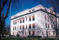 |
(#00001225) |
300 4th St. 44°39′26″N 97°12′11″W / 44.657222°N 97.203056°W |
Hayti | |
| 6 | M. O. Hanson Building | 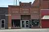 |
(#11000486) |
126 E. Main St. 44°43′19″N 97°02′09″W / 44.721944°N 97.035833°W |
Castlewood | |
| 7 | Hendrick and Waldur Hendrickson Farm | Upload image | (#85003485) |
Highway 28 44°35′06″N 97°15′26″W / 44.585°N 97.257222°W |
Lake Norden | |
| 8 | Hoffelt Drug Store | Upload image | (#08000050) |
212 Main St. 44°34′35″N 96°54′08″W / 44.576389°N 96.902222°W |
Estelline | |
| 9 | Kant Hotel | Upload image | (#85003449) |
North of Highway 28 44°35′26″N 97°28′04″W / 44.590556°N 97.467778°W |
Bryant | |
| 10 | Charles and Mary Lohr House | Upload image | (#82003927) |
1705 State Ave. 44°34′23″N 96°53′37″W / 44.573056°N 96.893611°W |
Estelline | |
| 11 | Old St. Mary's Catholic Parish House | Upload image | (#88002840) |
5th Ave. and Underwood St. 44°35′19″N 97°27′57″W / 44.588611°N 97.465833°W |
Bryant | |
| 12 | South Dakota Dept. of Transportation Bridge No. 29-221-060 | Upload image | (#93001291) |
Local road over the Big Sioux River 44°42′59″N 97°02′41″W / 44.716389°N 97.044722°W |
Castlewood | |
| 13 | South Dakota Dept. of Transportation Bridge No. 29-279-010 | Upload image | (#93001292) |
Local road over Stray Horse Creek 44°47′24″N 96°55′35″W / 44.79°N 96.926389°W |
Castlewood | |
| 14 | Jacob and Amelia Tuohino Farm | Upload image | (#85003495) |
South of Highway 28 44°34′29″N 97°18′39″W / 44.574722°N 97.310833°W |
Lake Norden |
See also
| Wikimedia Commons has media related to National Register of Historic Places in Hamlin County, South Dakota. |
- List of National Historic Landmarks in South Dakota
- National Register of Historic Places listings in South Dakota
References
- ↑ The latitude and longitude information provided in this table was derived originally from the National Register Information System, which has been found to be fairly accurate for about 99% of listings. For about 1% of NRIS original coordinates, experience has shown that one or both coordinates are typos or otherwise extremely far off; some corrections may have been made. A more subtle problem causes many locations to be off by up to 150 yards, depending on location in the country: most NRIS coordinates were derived from tracing out latitude and longitudes off of USGS topographical quadrant maps created under the North American Datum of 1927, which differs from the current, highly accurate WGS84 GPS system used by most on-line maps. Chicago is about right, but NRIS longitudes in Washington are higher by about 4.5 seconds, and are lower by about 2.0 seconds in Maine. Latitudes differ by about 1.0 second in Florida. Some locations in this table may have been corrected to current GPS standards.
- ↑ "National Register of Historic Places: Weekly List Actions". National Park Service, United States Department of the Interior. Retrieved on May 1, 2015.
- ↑ Numbers represent an ordering by significant words. Various colorings, defined here, differentiate National Historic Landmarks and historic districts from other NRHP buildings, structures, sites or objects.
- ↑ "National Register Information System". National Register of Historic Places. National Park Service. 2008-04-24.
- ↑ The eight-digit number below each date is the number assigned to each location in the National Register Information System database, which can be viewed by clicking the number.
| ||||||||||||||||||||||||||
| |||||||||||||||||||||||||||||