National Register of Historic Places listings in Hale County, Alabama
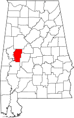
Location of Hale County in Alabama
This is a list of the National Register of Historic Places listings in Hale County, Alabama.
This is intended to be a complete list of the properties and districts on the National Register of Historic Places in Hale County, Alabama, United States. Latitude and longitude coordinates are provided for many National Register properties and districts; these locations may be seen together in a Google map.[1]
There are 20 properties and districts listed on the National Register in the county, including 2 National Historic Landmarks.
- This National Park Service list is complete through NPS recent listings posted May 1, 2015.[2]
Current listings
| [3] |
Name on the Register |
Image |
Date listed[4] |
Location |
City or town |
Description |
|---|
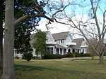
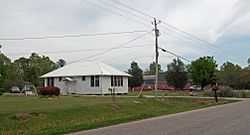
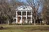
| 1 |
Battersea |
|
01994-07-07-0000July 7, 1994
(#94000698) |
County Road 8, east of its junction with State Route 69
32°30′37″N 87°42′11″W / 32.510278°N 87.703056°W / 32.510278; -87.703056 (Battersea) |
Prairieville |
|
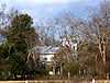
| 2 |
Bermuda Hill |
|
01994-07-07-0000July 7, 1994
(#94000692) |
State Route 69 north of its junction with County Road 2
32°31′48″N 87°41′39″W / 32.53°N 87.694167°W / 32.53; -87.694167 (Bermuda Hill) |
Prairieville |
|
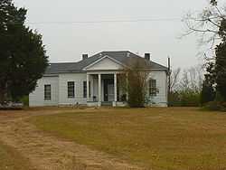
| 3 |
Borden Oaks |
|
01994-07-07-0000July 7, 1994
(#94000685) |
North of County Road 28, east of its junction with State Route 14
32°43′04″N 87°41′21″W / 32.717778°N 87.689167°W / 32.717778; -87.689167 (Borden Oaks) |
Greensboro |
|
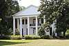
| 4 |
Emory School |
|
01998-02-20-0000February 20, 1998
(#98000109) |
County Road 16, approximately 1 mile west of its junction with State Route 69
32°36′46″N 87°41′48″W / 32.612778°N 87.696667°W / 32.612778; -87.696667 (Emory School) |
Greensboro |
|
| 5 |
John Erwin House |
|
01978-01-18-0000January 18, 1978
(#78000488) |
705 Erwin Dr.
32°42′12″N 87°35′45″W / 32.703333°N 87.595833°W / 32.703333; -87.595833 (John Erwin House) |
Greensboro |
|
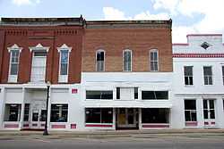
| 6 |
Greensboro Historic District |
|
01976-08-13-0000August 13, 1976
(#76000328) |
Main St. between Hobson and 1st
32°42′14″N 87°36′05″W / 32.703889°N 87.601389°W / 32.703889; -87.601389 (Greensboro Historic District) |
Greensboro |
|
| 7 |
Hatch House |
|
01991-10-11-0000October 11, 1991
(#91001483) |
Junction of State Route 14 and Norfleet Rd.
32°43′23″N 87°37′43″W / 32.723056°N 87.628611°W / 32.723056; -87.628611 (Hatch House) |
Greensboro |
|
| 8 |
Alfred Hatch Place at Arcola |
|
01988-01-06-0000January 6, 1988
(#87001784) |
Route 1, County Road 2
32°33′59″N 87°46′12″W / 32.566389°N 87.77°W / 32.566389; -87.77 (Alfred Hatch Place at Arcola) |
Arcola |
|
| 9 |
Hawthorne |
|
01994-07-07-0000July 7, 1994
(#94000694) |
County Road 8 just north of its junction with State Route 69
32°30′50″N 87°41′59″W / 32.513889°N 87.699722°W / 32.513889; -87.699722 (Hawthorne) |
Prairieville |
|
| 10 |
Kerby House |
|
01994-07-07-0000July 7, 1994
(#94000697) |
County Road 8 southeast of its junction with State Route 69
32°30′21″N 87°41′14″W / 32.505833°N 87.687222°W / 32.505833; -87.687222 (Kerby House) |
Prairieville |
|
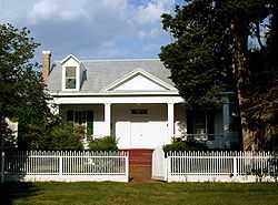
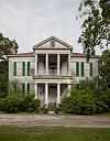
| 11 |
Magnolia Grove |
|
01973-04-11-0000April 11, 1973
(#73000345) |
Western end of Main St.
32°42′18″N 87°36′39″W / 32.705°N 87.610833°W / 32.705; -87.610833 (Magnolia Grove) |
Greensboro |
|
| 12 |
McGehee-Stringfellow House |
|
01980-09-17-0000September 17, 1980
(#80000686) |
Northwest of Greensboro on State Route 30
32°45′07″N 87°40′41″W / 32.751944°N 87.678056°W / 32.751944; -87.678056 (McGehee-Stringfellow House) |
Greensboro |
|
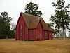
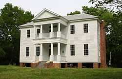
| 13 |
Millwood |
|
01989-09-26-0000September 26, 1989
(#89000314) |
Roughly bounded by Millwood Pond, County Road 17, and the Black Warrior River
32°39′34″N 87°44′59″W / 32.659444°N 87.749722°W / 32.659444; -87.749722 (Millwood) |
Greensboro |
|
| 14 |
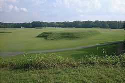
Moundville |
|
01966-10-15-0000October 15, 1966
(#66000149) |
1 mile (1.6 km) west of Moundville on State Route 21
33°00′23″N 87°37′56″W / 33.006389°N 87.632222°W / 33.006389; -87.632222 (Moundville) |
Moundville |
|
| 15 |
Oak Grove School |
|
01998-03-03-0000March 3, 1998
(#98000108) |
0.25 miles west of State Route 69, 1 mile north of the junction of U.S. Route 80 and State Route 69
32°32′48″N 87°40′48″W / 32.546667°N 87.68°W / 32.546667; -87.68 (Oak Grove School) |
Prairieville |
|
| 16 |
Payne House |
Upload image |
01994-07-07-0000July 7, 1994
(#94000690) |
U.S. Route 61 southeast of Greensboro
32°41′26″N 87°34′36″W / 32.690556°N 87.576667°W / 32.690556; -87.576667 (Payne House) |
Greensboro |
|
| 17 |
St. Andrew's Church |
|
01973-11-07-0000November 7, 1973
(#73000347) |
U.S. Route 80
32°30′39″N 87°42′05″W / 32.510833°N 87.701389°W / 32.510833; -87.701389 (St. Andrew's Church) |
Prairieville |
|
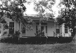
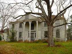
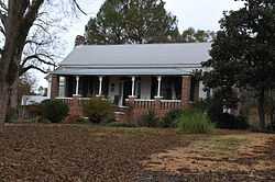
| 18 |
Augusta Sledge House |
|
01994-07-07-0000July 7, 1994
(#94000686) |
County Road 12 between State Routes 25 and 61, southwest of Newbern
32°31′11″N 87°34′08″W / 32.519722°N 87.568889°W / 32.519722; -87.568889 (Augusta Sledge House) |
Newbern |
Destroyed
|
| 19 |
Tanglewood |
|
01973-04-11-0000April 11, 1973
(#73000346) |
About 11 miles north of Greensboro off State Route 23
32°51′20″N 87°39′37″W / 32.855556°N 87.660278°W / 32.855556; -87.660278 (Tanglewood) |
Akron |
|
| 20 |
Waldwic |
|
01994-07-22-0000July 22, 1994
(#94000684) |
Western side of State Route 69, south of Gallion
32°29′03″N 87°42′56″W / 32.484167°N 87.715556°W / 32.484167; -87.715556 (Waldwic) |
Gallion |
|
See also
References
- ↑ The latitude and longitude information provided in this table was derived originally from the National Register Information System, which has been found to be fairly accurate for about 99% of listings. For about 1% of NRIS original coordinates, experience has shown that one or both coordinates are typos or otherwise extremely far off; some corrections may have been made. A more subtle problem causes many locations to be off by up to 150 yards, depending on location in the country: most NRIS coordinates were derived from tracing out latitude and longitudes off of USGS topographical quadrant maps created under the North American Datum of 1927, which differs from the current, highly accurate WGS84 GPS system used by most on-line maps. Chicago is about right, but NRIS longitudes in Washington are higher by about 4.5 seconds, and are lower by about 2.0 seconds in Maine. Latitudes differ by about 1.0 second in Florida. Some locations in this table may have been corrected to current GPS standards.
- ↑ "National Register of Historic Places: Weekly List Actions". National Park Service, United States Department of the Interior. Retrieved on May 1, 2015.
- ↑ Numbers represent an ordering by significant words. Various colorings, defined here, differentiate National Historic Landmarks and historic districts from other NRHP buildings, structures, sites or objects.
- ↑ The eight-digit number below each date is the number assigned to each location in the National Register Information System database, which can be viewed by clicking the number.
|
|---|
| | Lists by county | | |
|---|
| | Lists by city | |
|---|
| | Other lists | |
|---|
| |
|

.JPG)