National Register of Historic Places listings in Gregory County, South Dakota
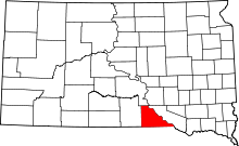
Location of Gregory County in South Dakota
This is a list of the National Register of Historic Places listings in Gregory County, South Dakota.
This is intended to be a complete list of the properties and districts on the National Register of Historic Places in Gregory County, South Dakota, United States. The locations of National Register properties and districts for which the latitude and longitude coordinates are included below, may be seen in a Google map.[1]
There are 11 properties and districts listed on the National Register in the county. Another 2 properties were once listed but have been removed.
- This National Park Service list is complete through NPS recent listings posted May 1, 2015.[2]
Current listings
| [3] | Name on the Register[4] | Image | Date listed[5] | Location | City or town | Description |
|---|---|---|---|---|---|---|
| 1 | Dallas Carnegie Library | Upload image | (#76001734) |
405 Main St. 43°14′10″N 99°31′02″W / 43.236111°N 99.517222°W |
Dallas | |
| 2 | Fort Randall | 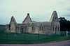 |
(#76001735) |
3 miles southwest of Pickstown 43°02′51″N 98°33′32″W / 43.0475°N 98.558889°W |
Pickstown | |
| 3 | Gregory Buttes Stone Steps | Upload image | (#04000763) |
200 and 300 blocks of 11th-14th Sts. 43°14′32″N 99°26′09″W / 43.242222°N 99.435833°W |
Gregory | |
| 4 | Gregory County State Bank | Upload image | (#98001399) |
Main St. at its junction with Randall St. 43°01′39″N 98°53′18″W / 43.0275°N 98.888333°W |
Fairfax | |
| 5 | Gregory National Bank | Upload image | (#13000573) |
524 Main St 43°13′56″N 99°25′52″W / 43.2321°N 99.4310°W |
Gregory | |
| 6 | Herrick Elevator | 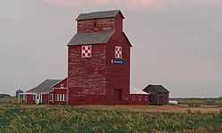 |
(#03000498) |
U.S. Route 18 43°07′26″N 99°10′58″W / 43.123889°N 99.182778°W |
Herrick | |
| 7 | Herrick Public School | Upload image | (#00001000) |
450 8th St. 43°06′54″N 99°11′15″W / 43.115°N 99.1875°W |
Herrick | |
| 8 | Pocahontas Schoolhouse | Upload image | (#73001743) |
4.5 miles northeast of Dixon 43°26′54″N 99°27′17″W / 43.448333°N 99.454722°W |
Dixon | |
| 9 | St. Augustine Church | Upload image | (#09000944) |
Southeastern corner of the junction of 6th and Main Sts. 43°14′02″N 99°31′01″W / 43.233936°N 99.516992°W |
Dallas | |
| 10 | St. John's Catholic Church | Upload image | (#09000945) |
Section 31 R96W 73N of Dickens Township, near Dallas Coordinates missing |
Dickens Township | |
| 11 | Tackett Underwood Building | Upload image | (#99000678) |
518 and 520 Main 43°13′55″N 99°25′51″W / 43.231944°N 99.430833°W |
Gregory |
Former listings
| [3] | Name on the Register | Image | Date listed | Date removed | Location | City or town | Summary |
|---|---|---|---|---|---|---|---|
| 1 | South Dakota Department of Transportation Bridge No. 27-000-201 | Upload image | (#93001289) | Local road over unnamed creek |
Dallas vicinity | ||
| 2 | South Dakota Department of Transportation Bridge No. 27-060-298 | Upload image | (#93001290) | |
Gregory vicinity |
See also
| Wikimedia Commons has media related to National Register of Historic Places in Gregory County, South Dakota. |
- List of National Historic Landmarks in South Dakota
- National Register of Historic Places listings in South Dakota
References
- ↑ The latitude and longitude information provided in this table was derived originally from the National Register Information System, which has been found to be fairly accurate for about 99% of listings. For about 1% of NRIS original coordinates, experience has shown that one or both coordinates are typos or otherwise extremely far off; some corrections may have been made. A more subtle problem causes many locations to be off by up to 150 yards, depending on location in the country: most NRIS coordinates were derived from tracing out latitude and longitudes off of USGS topographical quadrant maps created under the North American Datum of 1927, which differs from the current, highly accurate WGS84 GPS system used by most on-line maps. Chicago is about right, but NRIS longitudes in Washington are higher by about 4.5 seconds, and are lower by about 2.0 seconds in Maine. Latitudes differ by about 1.0 second in Florida. Some locations in this table may have been corrected to current GPS standards.
- ↑ "National Register of Historic Places: Weekly List Actions". National Park Service, United States Department of the Interior. Retrieved on May 1, 2015.
- ↑ 3.0 3.1 Numbers represent an ordering by significant words. Various colorings, defined here, differentiate National Historic Landmarks and historic districts from other NRHP buildings, structures, sites or objects.
- ↑ "National Register Information System". National Register of Historic Places. National Park Service. 2008-04-24.
- ↑ The eight-digit number below each date is the number assigned to each location in the National Register Information System database, which can be viewed by clicking the number.
| ||||||||||||||||||||||||||
| |||||||||||||||||||||||||||||