National Register of Historic Places listings in Grant County, Oregon
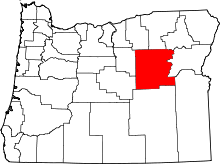
Location of Grant County in Oregon
This list presents the full set of buildings, structures, objects, sites, or districts designated on the National Register of Historic Places in Grant County, Oregon, and offers brief descriptive information about each of them. The National Register recognizes places of national, state, or local historic significance across the United States.[1] Out of over 90,000 National Register sites nationwide,[2] Oregon is home to over 1,950,[3] and 10 of those are found partially or wholly in Grant County.
- This National Park Service list is complete through NPS recent listings posted May 1, 2015.[4]
Current listings
| [5] |
Name on the Register |
Image |
Date listed[6] |
Location |
City or town |
Description |
|---|
| 1 |
Advent Christian Church |
|
01992-06-10-0000June 10, 1992
(#92000665) |
261 W. Main Street
44°24′59″N 118°57′14″W / 44.416499°N 118.954018°W / 44.416499; -118.954018 (Advent Christian Church) |
John Day |
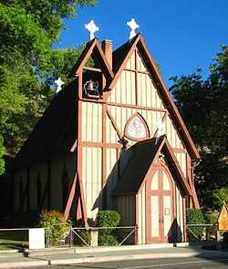
Outstandingly rich Victorian style ornamentation was applied to a classically simple Gothic Revival form in this 1900 church. It is believed that lay minister and carpenter Samuel Bayliss Hope was personally responsible for most of the decorative woodwork, including the unusually late use of hand-planed moldings.[7]
|
| 2 |
James Cant Ranch Historic District |
|
01984-06-21-0000June 21, 1984
(#84003000) |
Along Oregon Route 19
44°33′19″N 119°38′41″W / 44.555278°N 119.644722°W / 44.555278; -119.644722 (James Cant Ranch Historic District) |
Dayville |
|
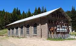
| 3 |
Fremont Powerhouse |
|
01983-08-19-0000August 19, 1983
(#83002151) |
Umatilla National Forest, along Forest Road 10
44°47′47″N 118°29′52″W / 44.796285°N 118.497718°W / 44.796285; -118.497718 (Fremont Powerhouse) |
Granite |
|
| 4 |
John Day Compound, Supervisor's Warehouse |
|
01986-04-11-0000April 11, 1986
(#86000836) |
179–199 Government Road
44°25′07″N 118°57′37″W / 44.418502°N 118.960151°W / 44.418502; -118.960151 (John Day Compound, Supervisor's Warehouse) |
John Day |
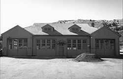
Built by the Civilian Conservation Corps in 1936–1946, this complex is the headquarters for field operations in the Malheur National Forest and is typical of projects carried out by the CCC on behalf of the Forest Service. It represents that era's shift in the Forest Service's architectural vision toward comprehensive site planning, as well as the Service's policy evolution from custodial superintendence of the national forests toward active natural resource management.[8]
|
| 5 |
Kam Wah Chung Company Building |
|
01973-03-20-0000March 20, 1973
(#73001575) |
John Day City Park
44°25′07″N 118°57′25″W / 44.418688°N 118.956922°W / 44.418688; -118.956922 (Kam Wah Chung Company Building) |
John Day |
The best known example of a Chinese mercantile and herb store in the United States. It embodies the role of immigrant Chinese in the post-Civil War expansion period of the western United States.[9]
|
| 6 |
St. Thomas' Episcopal Church |
|
01974-11-21-0000November 21, 1974
(#74001685) |
135 Washington Street
44°23′17″N 118°56′57″W / 44.388073°N 118.949058°W / 44.388073; -118.949058 (St. Thomas' Episcopal Church) |
Canyon City |
|
| 7 |
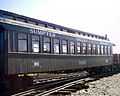
Sumpter Valley Railway Historic District |
|
01987-08-03-0000August 3, 1987
(#87001065) |
Roughly between Baker and Prairie City starting near the McEwen station site and west to the Dixie Pass area (See also Baker County.)
44°37′13″N 118°20′07″W / 44.62038°N 118.3352°W / 44.62038; -118.3352 (Sumpter Valley Railway Historic District) |
Prairie City to Baker City |
|
| 8 |
Sumpter Valley Railway Passenger Station |
|
01981-05-05-0000May 5, 1981
(#81000483) |
Main and Bridge Streets
44°27′29″N 118°42′22″W / 44.457970°N 118.706208°W / 44.457970; -118.706208 (Sumpter Valley Railway Passenger Station) |
Prairie City |
|
| 9 |
Sumpter Valley Railway, Middle Fork (John Day River) Spur |
|
01987-08-03-0000August 3, 1987
(#87001066) |
Along the Middle Fork John Day River
44°38′47″N 118°40′08″W / 44.646278°N 118.669005°W / 44.646278; -118.669005 (Sumpter Valley Railway, Middle Fork (John Day River) Spur) |
Bates to Susanville |
|
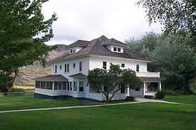
| 10 |
Supervisor's House No. 1001 |
|
01986-04-11-0000April 11, 1986
(#86000833) |
Malheur National Forest
44°24′42″N 118°57′00″W / 44.41166°N 118.95°W / 44.41166; -118.95 (Supervisor's House No. 1001) |
John Day |
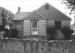
Malheur National Forest supervisor's residence in John Day, Oregon |
Former listings
| [5] |
Name on the Register |
Image |
Date listed | Date removed |
Location |
City or town |
Summary |
|---|
| 1 |
Dayville Hotel |
Upload image |
01983-03-10-0000March 10, 1983
(#83004521) | 01984-12-20-0000December 20, 1984 |
US 26
|
Dayville |
|
See also
References
- ↑ Andrus, Patrick W.; Shrimpton, Rebecca H. et al. (2002), How to Apply the National Register Criteria for Evaluation, National Register Bulletin (15), National Park Service, U.S. Department of the Interior, retrieved June 20, 2014 .
- ↑ National Park Service, National Register of Historic Places Program: Research, retrieved January 28, 2015 .
- ↑ Oregon Parks and Recreation Department, Oregon Historic Sites Database, retrieved July 26, 2014 . Note that a simple count of National Register records in this database returns a slightly higher total than actual listings, due to duplicate records. A close reading of detailed query results is necessary to arrive at the precise count.
- ↑ "National Register of Historic Places: Weekly List Actions". National Park Service, United States Department of the Interior. Retrieved on May 1, 2015.
- ↑ 5.0 5.1 Numbers represent an ordering by significant words. Various colorings, defined here, differentiate National Historic Landmarks and historic districts from other NRHP buildings, structures, sites or objects.
- ↑ The eight-digit number below each date is the number assigned to each location in the National Register Information System database, which can be viewed by clicking the number.
- ↑ Lyon, Louise; Allen, Lorene; Netsch, Timothy (December 15, 1991), National Register of Historic Places Registration Form: Advent Christian Church (PDF), retrieved October 3, 2014 .
- ↑ Anonymous (February 25, 1986), National Register of Historic Places Inventory — Nomination Form: John Day Compound, Supervisor's Warehouse (PDF), retrieved March 17, 2013 .
- ↑ National Park Service. "National Historic Landmark Program: NHL Database". Retrieved 2007-10-10.
External links
|
|---|
| | Topics | |
|---|
| | Lists by states | |
|---|
| | Lists by insular areas | |
|---|
| | Lists by associated states | |
|---|
| | Other areas | |
|---|
|
-
 Category Category
-
 Portal Portal
-
 WikiProject WikiProject
|
|
_(graDA0085).jpg)
_(graDA0091a).jpg)


 Media related to National Register of Historic Places in Grant County, Oregon at Wikimedia Commons