National Register of Historic Places listings in Gilmer County, West Virginia
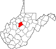
Location of Gilmer County in West Virginia
This is a list of the National Register of Historic Places listings in Gilmer County, West Virginia.
This is intended to be a complete list of the properties and districts on the National Register of Historic Places in Gilmer County, West Virginia, United States. The locations of National Register properties and districts for which the latitude and longitude coordinates are included below, may be seen in a Google map.[1]
There are 10 properties listed on the National Register in the county.
- This National Park Service list is complete through NPS recent listings posted May 1, 2015.[2]
Current listings
| [3] |
Name on the Register |
Image |
Date listed[4] |
Location |
City or town |
Description |
|---|
| 1 |
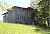
John E. Arbuckle House |
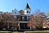
|
01991-11-21-0000November 21, 1991
(#91001729) |
213 Court St.
38°56′05″N 80°50′08″W / 38.934722°N 80.835556°W / 38.934722; -80.835556 (John E. Arbuckle House) |
Glenville |
|
| 2 |
Cedarville School |
|
01994-03-25-0000March 25, 1994
(#94000210) |
Junction of Smith Ave. and Edmond St.
38°50′25″N 80°49′08″W / 38.840278°N 80.818889°W / 38.840278; -80.818889 (Cedarville School) |
Cedarville |
|
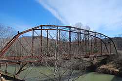
| 3 |
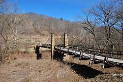
Duck Run Cable Suspension Bridge |
|
01997-07-09-0000July 9, 1997
(#97000783) |
Over the Little Kanawha River south of the junction of WV 5 and County Route 30
38°55′38″N 80°47′28″W / 38.927222°N 80.791111°W / 38.927222; -80.791111 (Duck Run Cable Suspension Bridge) |
Trubada |
|
| 4 |
Gilmer County Poor Farm Infirmary |
|
01998-12-04-0000December 4, 1998
(#98001465) |
Off Sycamore Rd. on Recreation Center Rd.
38°57′02″N 80°49′46″W / 38.950443°N 80.829433°W / 38.950443; -80.829433 (Gilmer County Poor Farm Infirmary) |
Glenville |
|
| 5 |
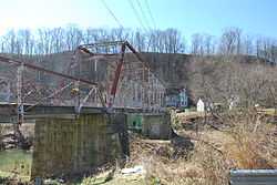
Glenville Truss Bridge |
|
01998-12-04-0000December 4, 1998
(#98001477) |
Conrad Court over the Little Kanawha River
38°55′58″N 80°50′20″W / 38.932778°N 80.838889°W / 38.932778; -80.838889 (Glenville Truss Bridge) |
Glenville |
|
| 6 |
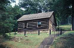
Job's Temple |
|
01979-05-29-0000May 29, 1979
(#79002575) |
West of Glenville on WV 5
38°55′56″N 80°57′45″W / 38.932222°N 80.9625°W / 38.932222; -80.9625 (Job's Temple) |
Glenville |
|
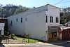
| 7 |
Little Kanawha Valley Bank |
|
01991-08-05-0000August 5, 1991
(#91001012) |
5 Howard St.
38°56′01″N 80°50′10″W / 38.933611°N 80.836111°W / 38.933611; -80.836111 (Little Kanawha Valley Bank) |
Glenville |
|
| 8 |
Ruddell General Store |
|
01998-12-15-0000December 15, 1998
(#98001469) |
6 Court St.
38°56′02″N 80°50′16″W / 38.933889°N 80.837778°W / 38.933889; -80.837778 (Ruddell General Store) |
Glenville |
|
| 9 |
Stouts Mill Bridge |
|
01998-12-04-0000December 4, 1998
(#98001476) |
Duskcamp Rd., over the Little Kanawha River
38°53′47″N 80°43′54″W / 38.896389°N 80.731667°W / 38.896389; -80.731667 (Stouts Mill Bridge) |
Stouts Mill |
|
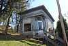
| 10 |
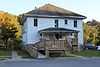
Whiting House |
|
01998-12-04-0000December 4, 1998
(#98001480) |
301 E. Main St.
38°55′57″N 80°50′12″W / 38.9325°N 80.836667°W / 38.9325; -80.836667 (Whiting House) |
Glenville |
|
See also
References
- ↑ The latitude and longitude information provided in this table was derived originally from the National Register Information System, which has been found to be fairly accurate for about 99% of listings. For about 1% of NRIS original coordinates, experience has shown that one or both coordinates are typos or otherwise extremely far off; some corrections may have been made. A more subtle problem causes many locations to be off by up to 150 yards, depending on location in the country: most NRIS coordinates were derived from tracing out latitude and longitudes off of USGS topographical quadrant maps created under the North American Datum of 1927, which differs from the current, highly accurate WGS84 GPS system used by most on-line maps. Chicago is about right, but NRIS longitudes in Washington are higher by about 4.5 seconds, and are lower by about 2.0 seconds in Maine. Latitudes differ by about 1.0 second in Florida. Some locations in this table may have been corrected to current GPS standards.
- ↑ "National Register of Historic Places: Weekly List Actions". National Park Service, United States Department of the Interior. Retrieved on May 1, 2015.
- ↑ Numbers represent an ordering by significant words. Various colorings, defined here, differentiate National Historic Landmarks and historic districts from other NRHP buildings, structures, sites or objects.
- ↑ The eight-digit number below each date is the number assigned to each location in the National Register Information System database, which can be viewed by clicking the number.
|
|---|
| | Topics | | |
|---|
| | Lists by county | |
|---|
| | Other lists | |
|---|
|
-
 Category:National Register of Historic Places in West Virginia Category:National Register of Historic Places in West Virginia
-
 Portal:National Register of Historic Places Portal:National Register of Historic Places
|
|