| [3] |
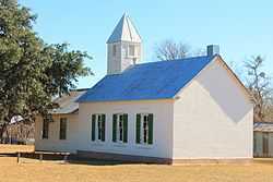
Name on the Register[4] |
Image |
Date listed[5] |
Location |
City or town |
Description |
|---|
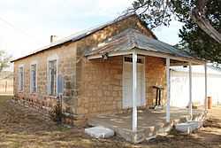
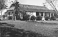
| 1 |
Cave Creek School |
|
02004-12-29-0000December 29, 2004
(#04001415) |
470 Cave Creek Rd.
30°18′30″N 98°43′37″W / 30.308333°N 98.726944°W / 30.308333; -98.726944 (Cave Creek School) |
Fredericksburg |
|
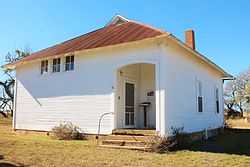
| 2 |
Cherry Spring School |
|
02005-05-06-0000May 6, 2005
(#05000389) |
5973 RM 2323
30°27′50″N 98°56′54″W / 30.463889°N 98.948333°W / 30.463889; -98.948333 (Cherry Spring School) |
Fredericksburg |
|
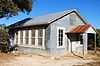
| 3 |
Crabapple School |
|
02005-05-06-0000May 6, 2005
(#05000390) |
14671 Lower Crabapple Rd.
30°26′30″N 98°49′54″W / 30.441667°N 98.831667°W / 30.441667; -98.831667 (Crabapple School) |
Fredericksburg |
|
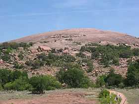
| 4 |
Enchanted Rock Archeological District |
|
01984-08-29-0000August 29, 1984
(#84001740) |
Off Ranch Rd 965 at the Gillespie-Llano county line
30°30′20″N 98°49′05″W / 30.505556°N 98.818056°W / 30.505556; -98.818056 (Enchanted Rock Archeological District) |
Fredericksburg |
Extends into Llano County
|
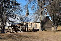
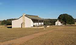
| 5 |
Fort Martin Scott |
|
01980-01-20-0000January 20, 1980
(#80004121) |
The south side of Fredericksburg on US Hwy 290
30°14′58″N 98°50′47″W / 30.249444°N 98.846389°W / 30.249444; -98.846389 (Fort Martin Scott) |
Fredericksburg |
|
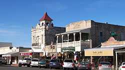
| 6 |
Fredericksburg Historic District |
|
01970-10-14-0000October 14, 1970
(#70000749) |
Roughly bunded by Elk, Schubert, Acorn, and Creek Sts
30°16′33″N 98°52′25″W / 30.275833°N 98.873611°W / 30.275833; -98.873611 (Fredericksburg Historic District) |
Fredericksburg |
|
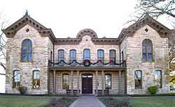
| 7 |
Fredericksburg Memorial Library |
|
01971-03-11-0000March 11, 1971
(#71000935) |
Courthouse Sq.
30°16′31″N 98°52′24″W / 30.275278°N 98.873333°W / 30.275278; -98.873333 (Fredericksburg Memorial Library) |
Fredericksburg |
|
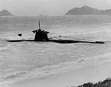
| 8 |
HA. 19 (Japanese Midget Submarine) |
|
01989-06-30-0000June 30, 1989
(#89001428) |
National Museum of the Pacific War, 340 East Main St
30°16′22″N 98°52′03″W / 30.272778°N 98.8675°W / 30.272778; -98.8675 (HA. 19 (Japanese Midget Submarine)) |
Fredericksburg |
Part of the Japanese attack force Pearl Harbor that accidentally grounded and was captured. Its location was Monroe County, Florida but was moved to the National Museum of the Pacific War.
|
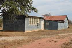
| 9 |
Lower South Grape Creek School |
|
02005-05-06-0000May 6, 2005
(#05000391) |
10273 E US 290
30°13′29″N 98°43′41″W / 30.224722°N 98.728056°W / 30.224722; -98.728056 (Lower South Grape Creek School) |
Luckenbach |
|
| 10 |
Luckenbach School |
|
02005-05-06-0000May 6, 2005
(#05000392) |
3566 Luckenbach Rd.
30°11′12″N 98°45′16″W / 30.186667°N 98.754444°W / 30.186667; -98.754444 (Luckenbach School) |
Luckenbach |
|
| 11 |
Lyndon B. Johnson National Historical Park |
|
01969-12-02-0000December 2, 1969
(#69000202) |
Lyndon B. Johnson National Historical Park
30°16′17″N 98°24′53″W / 30.271389°N 98.414722°W / 30.271389; -98.414722 (Lyndon B. Johnson National Historical Park) |
Johnson City |
Birthplace, home and ranch of President Lyndon B. Johnson.
|
| 12 |
Meusebach Creek School |
|
02005-05-06-0000May 6, 2005
(#05000393) |
515 Kuhlmann Rd.
30°12′22″N 98°51′23″W / 30.206111°N 98.856389°W / 30.206111; -98.856389 (Meusebach Creek School) |
Fredericksburg |
|
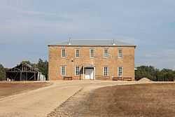
| 13 |
Morris Ranch Schoolhouse |
Upload image |
01983-03-29-0000March 29, 1983
(#83003142) |
Morris Ranch Rd.
30°13′07″N 99°00′56″W / 30.218611°N 99.015556°W / 30.218611; -99.015556 (Morris Ranch Schoolhouse) |
Morris Ranch |
|
| 14 |
Nebgen School |
|
02005-05-06-0000May 6, 2005
(#05000394) |
1718 N. Grape Creek Rd.
30°19′01″N 98°37′18″W / 30.316944°N 98.621667°W / 30.316944; -98.621667 (Nebgen School) |
Fredericksburg |
|
| 15 |
Pecan Creek School |
|
02005-05-10-0000May 10, 2005
(#05000418) |
3410 Pecan Creek Rd.
30°22′59″N 98°59′42″W / 30.383056°N 98.995°W / 30.383056; -98.995 (Pecan Creek School) |
Fredericksburg |
|
| 16 |
Rheingold School |
|
02005-05-06-0000May 6, 2005
(#05000388) |
334 Rheingold School Rd.
30°20′42″N 98°41′13″W / 30.345°N 98.686944°W / 30.345; -98.686944 (Rheingold School) |
Fredericksburg |
|
| 17 |
St. Mary's Catholic Church |
|
01983-06-21-0000June 21, 1983
(#83003143) |
306 W. San Antonio
30°16′37″N 98°52′37″W / 30.276944°N 98.876944°W / 30.276944; -98.876944 (St. Mary's Catholic Church) |
Fredericksburg |
|
| 18 |
Williams Creek School |
|
02005-05-06-0000May 6, 2005
(#05000384) |
5501 South RM 1623
30°11′45″N 98°36′01″W / 30.195833°N 98.600278°W / 30.195833; -98.600278 (Williams Creek School) |
Stonewall |
|
| 19 |
Willow City School |
|
02005-05-06-0000May 6, 2005
(#05000385) |
2501 RM 1323
30°24′06″N 98°42′17″W / 30.401667°N 98.704722°W / 30.401667; -98.704722 (Willow City School) |
Willow City |
|
| 20 |
Wrede School |
|
02005-06-01-0000June 1, 2005
(#05000519) |
3929 S. TX 16
30°13′58″N 98°54′34″W / 30.232778°N 98.909444°W / 30.232778; -98.909444 (Wrede School) |
Fredericksburg |
|

.jpg)