National Register of Historic Places listings in Gibson County, Tennessee

Location of Gibson County in Tennessee
This is a list of the National Register of Historic Places listings in Gibson County, Tennessee.
This is intended to be a complete list of the properties and districts on the National Register of Historic Places in Gibson County, Tennessee, United States. Latitude and longitude coordinates are provided for many National Register properties and districts; these locations may be seen together in a Google map.[1]
There are 17 properties and districts listed on the National Register in the county.
- This National Park Service list is complete through NPS recent listings posted May 1, 2015.[2]
Current listings
| [3] |
Name on the Register[4] |
Image |
Date listed[5] |
Location |
City or town |
Description |
|---|
| 1 |
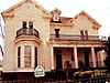
Bonds House |
Upload image |
02010-08-30-0000August 30, 2010
(#10000473) |
204 S. 19th Ave.
35°49′06″N 88°54′35″W / 35.818333°N 88.909722°W / 35.818333; -88.909722 (Bonds House) |
Humboldt |
|
| 2 |
Browning House |
Upload image |
01974-06-28-0000June 28, 1974
(#74001912) |
East of Milan on the Milan Army Ammunition Plant
35°55′27″N 88°43′10″W / 35.924167°N 88.719444°W / 35.924167; -88.719444 (Browning House) |
Milan |
|
| 3 |
Dodson House |
Upload image |
01982-03-25-0000March 25, 1982
(#82003969) |
119 N. 17th Ave.
35°49′14″N 88°54′47″W / 35.820556°N 88.913056°W / 35.820556; -88.913056 (Dodson House) |
Humboldt |
|
| 4 |
First Methodist Episcopal Church, South |
Upload image |
02008-07-23-0000July 23, 2008
(#08000702) |
200 N. 12th Ave.
35°49′15″N 88°55′08″W / 35.820833°N 88.918889°W / 35.820833; -88.918889 (First Methodist Episcopal Church, South) |
Humboldt |
|
| 5 |
Julius Freed House |
|
01994-04-05-0000April 5, 1994
(#94000301) |
Eaton St. west of the Gibson County Courthouse
35°58′49″N 88°56′18″W / 35.980278°N 88.938333°W / 35.980278; -88.938333 (Julius Freed House) |
Trenton |
|
| 6 |
Gibson County Courthouse |
Upload image |
01976-11-07-0000November 7, 1976
(#76001777) |
Court Sq.
35°58′51″N 88°56′29″W / 35.980833°N 88.941389°W / 35.980833; -88.941389 (Gibson County Courthouse) |
Trenton |
|
| 7 |
Gibson County Training School |
Upload image |
02012-03-12-0000March 12, 2012
(#12000117) |
1041 S. Harris St.
35°58′51″N 88°56′29″W / 35.980833°N 88.941389°W / 35.980833; -88.941389 (Gibson County Training School) |
Milan |
|
| 8 |
Medina City Hall |
Upload image |
02004-07-07-0000July 7, 2004
(#04000674) |
115 2nd St.
35°48′16″N 88°46′36″W / 35.804444°N 88.776667°W / 35.804444; -88.776667 (Medina City Hall) |
Medina |
|
| 9 |
Oakland Cemetery |
Upload image |
02007-03-20-0000March 20, 2007
(#07000186) |
800 Brownsville St.
35°58′17″N 88°56′40″W / 35.971389°N 88.944444°W / 35.971389; -88.944444 (Oakland Cemetery) |
Trenton |
|
| 10 |
Peabody High School |
Upload image |
01984-11-23-0000November 23, 1984
(#84000326) |
S. College St.
35°58′10″N 88°56′31″W / 35.969444°N 88.941944°W / 35.969444; -88.941944 (Peabody High School) |
Trenton |
|
| 11 |
Senter-Rooks House |
Upload image |
01980-07-09-0000July 9, 1980
(#80003797) |
2227 Main St.
35°49′15″N 88°54′22″W / 35.820833°N 88.906111°W / 35.820833; -88.906111 (Senter-Rooks House) |
Humboldt |
|
| 12 |
Skullbone Store |
|
01999-11-18-0000November 18, 1999
(#99001369) |
1 Shade's Bridge Rd.
36°05′02″N 88°45′41″W / 36.083889°N 88.761389°W / 36.083889; -88.761389 (Skullbone Store) |
Skullbone |
|
| 13 |
Col. Robert Z. Taylor House |
Upload image |
01982-04-12-0000April 12, 1982
(#82003970) |
1008 S. College St.
35°58′05″N 88°56′31″W / 35.968056°N 88.941944°W / 35.968056; -88.941944 (Col. Robert Z. Taylor House) |
Trenton |
|
| 14 |
Trenton Historic District |
Upload image |
01982-04-15-0000April 15, 1982
(#82003971) |
High, College, and Church Sts.
35°58′34″N 88°56′30″W / 35.976111°N 88.941667°W / 35.976111; -88.941667 (Trenton Historic District) |
Trenton |
|
| 15 |
Union Central School |
Upload image |
01985-07-05-0000July 5, 1985
(#85001490) |
Union Central Rd.
35°57′54″N 88°47′04″W / 35.965°N 88.784444°W / 35.965; -88.784444 (Union Central School) |
Milan |
|
| 16 |
US Post Office |
Upload image |
01987-07-09-0000July 9, 1987
(#87001169) |
382 S. Main St.
35°55′02″N 88°45′51″W / 35.917222°N 88.764167°W / 35.917222; -88.764167 (US Post Office) |
Milan |
|
| 17 |
US Post Office |
|
01988-09-23-0000September 23, 1988
(#88001576) |
200 S. College St.
35°58′55″N 88°56′30″W / 35.981944°N 88.941667°W / 35.981944; -88.941667 (US Post Office) |
Trenton |
|
See also
References
- ↑ The latitude and longitude information provided in this table was derived originally from the National Register Information System, which has been found to be fairly accurate for about 99% of listings. For about 1% of NRIS original coordinates, experience has shown that one or both coordinates are typos or otherwise extremely far off; some corrections may have been made. A more subtle problem causes many locations to be off by up to 150 yards, depending on location in the country: most NRIS coordinates were derived from tracing out latitude and longitudes off of USGS topographical quadrant maps created under the North American Datum of 1927, which differs from the current, highly accurate WGS84 GPS system used by most on-line maps. Chicago is about right, but NRIS longitudes in Washington are higher by about 4.5 seconds, and are lower by about 2.0 seconds in Maine. Latitudes differ by about 1.0 second in Florida. Some locations in this table may have been corrected to current GPS standards.
- ↑ "National Register of Historic Places: Weekly List Actions". National Park Service, United States Department of the Interior. Retrieved on May 1, 2015.
- ↑ Numbers represent an ordering by significant words. Various colorings, defined here, differentiate National Historic Landmarks and historic districts from other NRHP buildings, structures, sites or objects.
- ↑ "National Register Information System". National Register of Historic Places. National Park Service. 2008-04-24.
- ↑ The eight-digit number below each date is the number assigned to each location in the National Register Information System database, which can be viewed by clicking the number.
|
|---|
| | Topics | |
|---|
| | Lists by states | |
|---|
| | Lists by insular areas | |
|---|
| | Lists by associated states | |
|---|
| | Other areas | |
|---|
|
-
 Category Category
-
 Portal Portal
-
 WikiProject WikiProject
|
|