National Register of Historic Places listings in Garfield County, Colorado

Location of Garfield County in Colorado
This is a list of the National Register of Historic Places listings in Garfield County, Colorado. It is intended to be a complete list of the properties and districts on the National Register of Historic Places in Garfield County, Colorado, United States. The locations of National Register properties and districts for which the latitude and longitude coordinates are included below, may be seen in a Google map.[1]
There are 19 properties and districts listed on the National Register in the county.
- This National Park Service list is complete through NPS recent listings posted May 1, 2015.[2]
Listings county-wide
| [3] |
Name on the Register[4] |
Image |
Date listed[5] |
Location |
City or town |
Description |
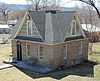
|---|
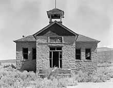
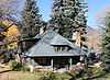
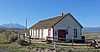
| 1 |
Battlement Mesa Schoolhouse |
|
01983-04-21-0000April 21, 1983
(#83001295) |
7201 300 Rd.
39°26′05″N 108°01′43″W / 39.434722°N 108.028611°W / 39.434722; -108.028611 (Battlement Mesa Schoolhouse) |
Battlement Mesa |
|
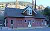
| 2 |
Canyon (Canon) Creek School, District No. 32 |
|
02004-01-06-0000January 6, 2004
(#03001360) |
0566 County Road 137
39°34′55″N 107°26′54″W / 39.581944°N 107.448333°W / 39.581944; -107.448333 (Canyon (Canon) Creek School, District No. 32) |
Glenwood Springs |
|
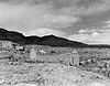
| 3 |
Cardiff Coke Ovens |
|
01996-11-15-0000November 15, 1996
(#96001331) |
County Road 116 approximately 1.5 miles south of Glenwood
39°30′17″N 107°18′38″W / 39.504722°N 107.310556°W / 39.504722; -107.310556 (Cardiff Coke Ovens) |
Glenwood Springs |
|
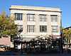
| 4 |
Citizens National Bank Building |
|
01999-07-15-0000July 15, 1999
(#99000824) |
801 Grand Ave.
39°32′47″N 107°19′27″W / 39.546389°N 107.324167°W / 39.546389; -107.324167 (Citizens National Bank Building) |
Glenwood Springs |
|
| 5 |
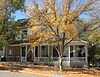
Earnest Ranch |
|
01998-04-01-0000April 1, 1998
(#98000292) |
6471 County Road 117
39°26′26″N 107°18′42″W / 39.440556°N 107.311667°W / 39.440556; -107.311667 (Earnest Ranch) |
Glenwood Springs |
|
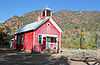
| 6 |
Glenwood Springs Hydroelectric Plant |
|
01998-10-14-0000October 14, 1998
(#98001244) |
601 6th St.
39°33′01″N 107°19′14″W / 39.550278°N 107.320556°W / 39.550278; -107.320556 (Glenwood Springs Hydroelectric Plant) |
Glenwood Springs |
|
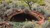
| 7 |
Havemeyer-Willcox Canal Pumphouse and Forebay |
|
01980-04-22-0000April 22, 1980
(#80000900) |
West of Rifle
39°30′00″N 107°55′05″W / 39.5°N 107.918056°W / 39.5; -107.918056 (Havemeyer-Willcox Canal Pumphouse and Forebay) |
Rifle |
|
| 8 |
Holland-Thompson Property |
Upload image |
02013-07-23-0000July 23, 2013
(#13000524) |
1605 SH 133
39°23′36″N 107°12′45″W / 39.393435°N 107.212492°W / 39.393435; -107.212492 (Holland-Thompson Property) |
Carbondale |
|
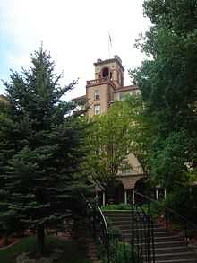
| 9 |
Hotel Colorado |
|
01977-05-26-0000May 26, 1977
(#77000376) |
526 Pine St.
39°34′25″N 107°19′28″W / 39.573611°N 107.324444°W / 39.573611; -107.324444 (Hotel Colorado) |
Glenwood Springs |
|
| 10 |
Missouri Heights School |
|
01999-09-23-0000September 23, 1999
(#99001145) |
County Road 102, 0.5 miles east of its junction with County Road 100
39°25′56″N 107°08′14″W / 39.432222°N 107.137222°W / 39.432222; -107.137222 (Missouri Heights School) |
Carbondale |
|
| 11 |
John Herbert Nunns House |
Upload image |
02013-12-03-0000December 3, 2013
(#13000871) |
311 N. 7th St.
39°32′56″N 107°39′22″W / 39.549016°N 107.655985°W / 39.549016; -107.655985 (John Herbert Nunns House) |
Silt |
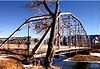
|
| 12 |
Rifle Bridge |
|
01985-02-04-0000February 4, 1985
(#85000213) |
Off U.S. Highway 6 over the Colorado River
39°31′41″N 107°46′51″W / 39.528056°N 107.780833°W / 39.528056; -107.780833 (Rifle Bridge) |
Rifle |
|
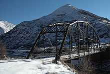
| 13 |
Satank Bridge |
|
01985-02-04-0000February 4, 1985
(#85000211) |
County Road 106
39°25′02″N 107°13′48″W / 39.417222°N 107.23°W / 39.417222; -107.23 (Satank Bridge) |
Carbondale |
|
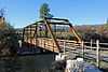
| 14 |
South Canon Bridge |
|
01985-02-04-0000February 4, 1985
(#85000212) |
County Road 134
39°33′42″N 107°24′23″W / 39.561667°N 107.406389°W / 39.561667; -107.406389 (South Canon Bridge) |
Glenwood Springs |
|
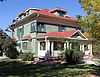
| 15 |
Starr Manor |
|
01986-06-20-0000June 20, 1986
(#86001350) |
901 Palmer Ave.
39°32′43″N 107°19′13″W / 39.545278°N 107.320278°W / 39.545278; -107.320278 (Starr Manor) |
Glenwood Springs |
|
| 16 |
Sumers Lodge |
|
01997-06-20-0000June 20, 1997
(#97000593) |
1200 Mountain Dr.
39°30′48″N 107°18′53″W / 39.513333°N 107.314722°W / 39.513333; -107.314722 (Sumers Lodge) |
Glenwood Springs |
|
| 17 |
Edward T. Taylor House |
|
01986-10-14-0000October 14, 1986
(#86002807) |
903 Bennett Ave.
39°32′43″N 107°19′16″W / 39.545278°N 107.321111°W / 39.545278; -107.321111 (Edward T. Taylor House) |
Glenwood Springs |
|
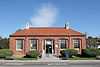
| 18 |
US Post Office-Rifle Main |
|
01986-01-24-0000January 24, 1986
(#86000186) |
Railroad Ave. and 4th St.
39°31′57″N 107°47′02″W / 39.5325°N 107.783889°W / 39.5325; -107.783889 (US Post Office-Rifle Main) |
Rifle |
|
| 19 |
Wasson-McKay Place |
|
02010-08-05-0000August 5, 2010
(#10000536) |
259 Cardinal Way
39°26′56″N 108°03′08″W / 39.448889°N 108.052222°W / 39.448889; -108.052222 (Wasson-McKay Place) |
Parachute |
|
See also
References
- ↑ The latitude and longitude information provided in this table was derived originally from the National Register Information System, which has been found to be fairly accurate for about 99% of listings. For about 1% of NRIS original coordinates, experience has shown that one or both coordinates are typos or otherwise extremely far off; some corrections may have been made. A more subtle problem causes many locations to be off by up to 150 yards, depending on location in the country: most NRIS coordinates were derived from tracing out latitude and longitudes off of USGS topographical quadrant maps created under the North American Datum of 1927, which differs from the current, highly accurate WGS84 GPS system used by most on-line maps. Chicago is about right, but NRIS longitudes in Washington are higher by about 4.5 seconds, and are lower by about 2.0 seconds in Maine. Latitudes differ by about 1.0 second in Florida. Some locations in this table may have been corrected to current GPS standards.
- ↑ "National Register of Historic Places: Weekly List Actions". National Park Service, United States Department of the Interior. Retrieved on May 1, 2015.
- ↑ Numbers represent an ordering by significant words. Various colorings, defined here, differentiate National Historic Landmarks and historic districts from other NRHP buildings, structures, sites or objects.
- ↑ "National Register Information System". National Register of Historic Places. National Park Service. 2008-04-24.
- ↑ The eight-digit number below each date is the number assigned to each location in the National Register Information System database, which can be viewed by clicking the number.
|
|---|
| | Topics | |
|---|
| | Lists by states | |
|---|
| | Lists by insular areas | |
|---|
| | Lists by associated states | |
|---|
| | Other areas | |
|---|
|
-
 Category Category
-
 Portal Portal
-
 WikiProject WikiProject
|
|