National Register of Historic Places listings in Gallia County, Ohio

Location of Gallia County in Ohio
This is a list of the National Register of Historic Places listings in Gallia County, Ohio.
This is intended to be a complete list of the properties and districts on the National Register of Historic Places in Gallia County, Ohio, United States. The locations of National Register properties and districts for which the latitude and longitude coordinates are included below, may be seen in a Google map.[1]
There are 8 properties and districts listed on the National Register in the county.
- This National Park Service list is complete through NPS recent listings posted May 1, 2015.[2]
Current listings
| [3] | Name on the Register[4] | Image | Date listed[5] | Location | City or town | Description |
|---|---|---|---|---|---|---|
| 1 | Davis Mill | 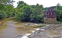 |
(#80003028) |
Northeast of Patriot on Cora Mill Rd. 38°49′29″N 82°22′10″W / 38.824722°N 82.369444°W |
Perry Township | The mill has recently collapsed from a combination of bad weather and general disrepair. No plans are currently underway to rebuild it. |
| 2 | Evans House | Upload image | (#84003692) |
Coal Valley Rd., southwest of Vinton 38°57′58″N 82°26′02″W / 38.966111°N 82.433889°W |
Huntington Township | |
| 3 | Ewington Academy | Upload image | (#82003572) |
Ewington Rd. at Ewington 39°00′36″N 82°21′17″W / 39.01°N 82.354722°W |
Huntington Township | |
| 4 | Gallipolis Historic District | |
(#80003027) |
Roughly bounded by 3rd Ave., Vine and Spruce Sts. and the Ohio River 38°48′24″N 82°12′20″W / 38.806667°N 82.205556°W |
Gallipolis | Originally listed on January 8, 1980 as the "Gallipolis Public Square and Garden Lots Historic District", with boundaries of 1st and 2nd Aves. and Court and State Sts.; boundaries increased and name changed on August 22, 2001[4] |
| 5 | Gatewood | 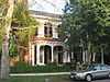 |
(#86002877) |
76 State St. 38°48′33″N 82°12′23″W / 38.809167°N 82.206389°W |
Gallipolis | |
| 6 | Ohio Hospital For Epileptics Stone Water Towers | 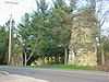 |
(#78002069) |
Mill Creek Rd. 38°49′17″N 82°11′13″W / 38.821389°N 82.186944°W |
Gallipolis | |
| 7 | Our House | 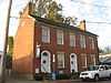 |
(#70000494) |
434 1st Ave. 38°48′28″N 82°12′13″W / 38.807778°N 82.203500°W |
Gallipolis | |
| 8 | Wood Old Homestead | 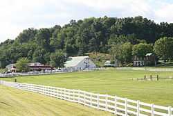 |
(#87002144) |
1253 Jackson Pike east of Rio Grande 38°52′57″N 82°22′03″W / 38.8825°N 82.3675°W |
Raccoon Township |
See also
| Wikimedia Commons has media related to National Register of Historic Places in Gallia County, Ohio. |
References
- ↑ The latitude and longitude information provided in this table was derived originally from the National Register Information System, which has been found to be fairly accurate for about 99% of listings. For about 1% of NRIS original coordinates, experience has shown that one or both coordinates are typos or otherwise extremely far off; some corrections may have been made. A more subtle problem causes many locations to be off by up to 150 yards, depending on location in the country: most NRIS coordinates were derived from tracing out latitude and longitudes off of USGS topographical quadrant maps created under the North American Datum of 1927, which differs from the current, highly accurate WGS84 GPS system used by most on-line maps. Chicago is about right, but NRIS longitudes in Washington are higher by about 4.5 seconds, and are lower by about 2.0 seconds in Maine. Latitudes differ by about 1.0 second in Florida. Some locations in this table may have been corrected to current GPS standards.
- ↑ "National Register of Historic Places: Weekly List Actions". National Park Service, United States Department of the Interior. Retrieved on May 1, 2015.
- ↑ Numbers represent an ordering by significant words. Various colorings, defined here, differentiate National Historic Landmarks and historic districts from other NRHP buildings, structures, sites or objects.
- ↑ 4.0 4.1 "National Register Information System". National Register of Historic Places. National Park Service. 2008-04-24.
- ↑ The eight-digit number below each date is the number assigned to each location in the National Register Information System database, which can be viewed by clicking the number.


| |||||||||||||||||||||||||