| [3] |
Name on the Register |
Image |
Date listed[4] |
Location |
City or town |
Description |
|---|
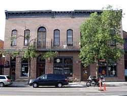
| 1 |
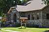
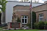
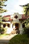
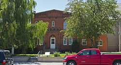
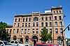
Adams Block |
Upload image |
01999-05-20-0000May 20, 1999
(#99000597) |
123 Main St.
45°53′36″N 111°33′05″W / 45.893333°N 111.551389°W / 45.893333; -111.551389 (Adams Block) |
Three Forks |
|
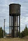
| 2 |
Airway Radio Station |
Upload image |
01998-11-05-0000November 5, 1998
(#98001340) |
Three Forks Airport
45°53′05″N 111°33′45″W / 45.884722°N 111.5625°W / 45.884722; -111.5625 (Airway Radio Station) |
Three Forks |
|
| 3 |
Anderson School |
Upload image |
01981-07-21-0000July 21, 1981
(#81000354) |
East of Gallatin Gateway
45°35′53″N 111°06′14″W / 45.598056°N 111.103889°W / 45.598056; -111.103889 (Anderson School) |
Gallatin Gateway |
|
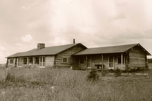
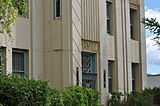
| 4 |
B--K Ranch |
Upload image |
02006-12-28-0000December 28, 2006
(#06001185) |
750 Lone Mountain Ranch Rd.
Coordinates missing |
Big Sky |
|
| 5 |
R.T. Barnett and Company Building |
Upload image |
01980-12-01-0000December 1, 1980
(#80002416) |
13 E. Main St.
45°40′43″N 111°02′12″W / 45.678611°N 111.036667°W / 45.678611; -111.036667 (R.T. Barnett and Company Building) |
Bozeman |
|
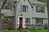
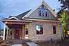
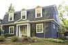
| 6 |
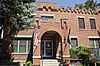
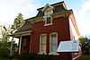
Jack Bartlett House |
|
02000-02-04-0000February 4, 2000
(#00000046) |
8 W. Harrison
45°40′08″N 111°02′59″W / 45.668889°N 111.049722°W / 45.668889; -111.049722 (Jack Bartlett House) |
Bozeman |
|
| 7 |
Beall Park Community Center |
|
01987-10-23-0000October 23, 1987
(#87001807) |
409 N. Bozeman
45°41′02″N 111°02′03″W / 45.683889°N 111.034167°W / 45.683889; -111.034167 (Beall Park Community Center) |
Bozeman |
|
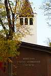
| 8 |
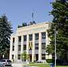
Belgrade City Hall and Jail |
Upload image |
01982-10-25-0000October 25, 1982
(#82000592) |
Broadway at Northern Pacific Boulevard
45°46′33″N 111°10′33″W / 45.775833°N 111.175833°W / 45.775833; -111.175833 (Belgrade City Hall and Jail) |
Belgrade |
|
| 9 |
Blackmore Apartments |
|
01983-07-07-0000July 7, 1983
(#83001062) |
120 S. Black St.
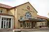
45°40′41″N 111°02′00″W / 45.678056°N 111.033333°W / 45.678056; -111.033333 (Blackmore Apartments) |
Bozeman |
|
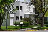
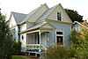
| 10 |
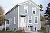
Bohart House |
|
01987-10-23-0000October 23, 1987
(#87001810) |
510 N. Church
45°41′07″N 111°01′42″W / 45.685278°N 111.028333°W / 45.685278; -111.028333 (Bohart House) |
Bozeman |
|
| 11 |
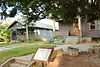
Bon Ton Historic District |
|
01987-10-23-0000October 23, 1987
(#87001816) |
Roughly bounded by Olive St., Willson Ave., Cleveland St., and 4th Ave.
45°40′38″N 111°02′36″W / 45.677222°N 111.043333°W / 45.677222; -111.043333 (Bon Ton Historic District) |
Bozeman |
|
| 12 |
Bozeman Armory |
|
01987-10-22-0000October 22, 1987
(#87001800) |
24 W. Mendenhall
45°40′49″N 111°02′14″W / 45.680278°N 111.037222°W / 45.680278; -111.037222 (Bozeman Armory) |
Bozeman |
|
| 13 |
Bozeman Brewery Historic District |
Upload image |
01987-10-23-0000October 23, 1987
(#87001844) |
700-800 N. Wallace Ave.
45°41′17″N 111°01′39″W / 45.688056°N 111.0275°W / 45.688056; -111.0275 (Bozeman Brewery Historic District) |
Bozeman |
|
| 14 |
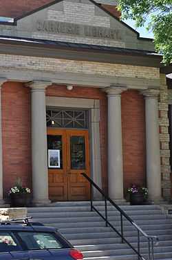
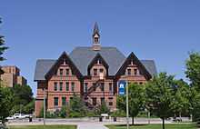
Bozeman Carnegie Library |
|
01979-02-02-0000February 2, 1979
(#79001402) |
35 N. Bozeman Ave.
45°40′49″N 111°02′04″W / 45.680278°N 111.0345°W / 45.680278; -111.0345 (Bozeman Carnegie Library) |
Bozeman |
|
| 15 |
Bozeman National Fish Hatchery |
|
01983-01-06-0000January 6, 1983
(#83001063) |
4050 Bridger Canyon Rd.
45°41′55″N 110°58′41″W / 45.698611°N 110.978056°W / 45.698611; -110.978056 (Bozeman National Fish Hatchery) |
Bozeman |
|
| 16 |
Bozeman Sheet Metal Works |
|
01987-10-23-0000October 23, 1987
(#87001836) |
26 S. Grand
45°40′44″N 111°02′20″W / 45.678889°N 111.038889°W / 45.678889; -111.038889 (Bozeman Sheet Metal Works) |
Bozeman |
|
| 17 |
Bozeman YMCA |
Upload image |
01987-10-23-0000October 23, 1987
(#87001819) |
6 W. Babcock
45°40′42″N 111°02′14″W / 45.678333°N 111.037222°W / 45.678333; -111.037222 (Bozeman YMCA) |
Bozeman |
|
| 18 |
Brandenburg House |
|
01987-10-23-0000October 23, 1987
(#87001804) |
122 W. Lamme
45°40′51″N 111°02′20″W / 45.680833°N 111.038889°W / 45.680833; -111.038889 (Brandenburg House) |
Bozeman |
|
| 19 |
Bridger Arms Apartments |
Upload image |
01987-10-23-0000October 23, 1987
(#87001799) |
103-111 S. 4th Ave.
45°40′41″N 111°02′30″W / 45.678056°N 111.041667°W / 45.678056; -111.041667 (Bridger Arms Apartments) |
Bozeman |
|
| 20 |
Busch House |
Upload image |
01987-10-23-0000October 23, 1987
(#87001805) |
224 N. Church
45°41′02″N 111°01′44″W / 45.683889°N 111.028889°W / 45.683889; -111.028889 (Busch House) |
Bozeman |
|
| 21 |
Buttelman Ranch |
Upload image |
01993-04-19-0000April 19, 1993
(#93000309) |
Address Restricted
|
Willow Creek |
|
| 22 |
Colburn House |
|
01987-10-23-0000October 23, 1987
(#87001813) |
607 W. Lamme
45°40′51″N 111°02′39″W / 45.680833°N 111.044167°W / 45.680833; -111.044167 (Colburn House) |
Bozeman |
|
| 23 |
Cooper Park Historic District |
Upload image |
01987-10-23-0000October 23, 1987
(#87001845) |
200-700 blocks of S. 5th, 6th, 7th, 8th, and Cross Sts.
45°40′31″N 111°02′40″W / 45.675278°N 111.044444°W / 45.675278; -111.044444 (Cooper Park Historic District) |
Bozeman |
|
| 24 |
Cottonwood School |
Upload image |
01981-07-21-0000July 21, 1981
(#81000356) |
Southeast of Gallatin Gateway
45°38′00″N 111°07′35″W / 45.633333°N 111.126389°W / 45.633333; -111.126389 (Cottonwood School) |
Gallatin Gateway |
|
| 25 |
Crail Ranch Buildings |
Upload image |
01982-04-15-0000April 15, 1982
(#82003167) |
Meadow Village
45°16′07″N 111°19′11″W / 45.268611°N 111.319722°W / 45.268611; -111.319722 (Crail Ranch Buildings) |
Gallatin Gateway |
|
| 26 |
Dokken-Nelson Funeral Home |
|
01987-12-21-0000December 21, 1987
(#87001833) |
113 S. Willson
45°40′42″N 111°02′19″W / 45.678333°N 111.038611°W / 45.678333; -111.038611 (Dokken-Nelson Funeral Home) |
Bozeman |
|
| 27 |
Dry Creek School |
Upload image |
01981-07-21-0000July 21, 1981
(#81000360) |
East of Manhattan
45°52′28″N 111°13′27″W / 45.874444°N 111.224167°W / 45.874444; -111.224167 (Dry Creek School) |
Manhattan |
|
| 28 |
Eagle's Store |
|
01986-11-06-0000November 6, 1986
(#86002957) |
3 Canyon St.
44°39′34″N 111°05′53″W / 44.659444°N 111.098056°W / 44.659444; -111.098056 (Eagle's Store) |
West Yellowstone |
|
| 29 |
Emerson School |
|
01990-08-10-0000August 10, 1990
(#90001212) |
111 S. Grand Ave.
45°40′42″N 111°02′22″W / 45.678333°N 111.039444°W / 45.678333; -111.039444 (Emerson School) |
Bozeman |
|
| 30 |
First Baptist Church |
|
01987-10-23-0000October 23, 1987
(#87001803) |
120 S. Grand
45°40′40″N 111°02′21″W / 45.677778°N 111.039167°W / 45.677778; -111.039167 (First Baptist Church) |
Bozeman |
|
| 31 |
First Presbyterian Church |
|
01987-12-21-0000December 21, 1987
(#87001820) |
26 W. Babcock
45°40′41″N 111°02′16″W / 45.678056°N 111.037778°W / 45.678056; -111.037778 (First Presbyterian Church) |
Bozeman |
|
| 32 |
Burr Fisher House |
|
01985-03-28-0000March 28, 1985
(#85000643) |
712 S. Willson Ave.
45°40′18″N 111°02′16″W / 45.671667°N 111.037778°W / 45.671667; -111.037778 (Burr Fisher House) |
Bozeman |
|
| 33 |
Flaming Arrow Lodge |
Upload image |
01994-07-29-0000July 29, 1994
(#94000784) |
15521 Bridger Canyon Rd.
45°48′34″N 110°53′03″W / 45.809444°N 110.884167°W / 45.809444; -110.884167 (Flaming Arrow Lodge) |
Bozeman |
|
| 34 |
Flaming Arrow Ranch House and Office |
Upload image |
01998-03-12-0000March 12, 1998
(#98000229) |
15325 Bridger Canyon Rd.
45°48′31″N 110°52′58″W / 45.808611°N 110.882778°W / 45.808611; -110.882778 (Flaming Arrow Ranch House and Office) |
Bozeman |
|
| 35 |
Gallatin County Courthouse |
|
01987-12-21-0000December 21, 1987
(#87001794) |
301 W. Main
45°40′47″N 111°02′28″W / 45.679722°N 111.041111°W / 45.679722; -111.041111 (Gallatin County Courthouse) |
Bozeman |
|
| 36 |
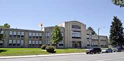
Gallatin County High School |
|
01988-01-22-0000January 22, 1988
(#87002309) |
404 W. Main
45°40′44″N 111°02′30″W / 45.678889°N 111.041667°W / 45.678889; -111.041667 (Gallatin County High School) |
Bozeman |
|
| 37 |
Gallatin County Jail |
|
01983-01-19-0000January 19, 1983
(#83001064) |
317 W. Main St.
45°40′47″N 111°02′30″W / 45.679722°N 111.041667°W / 45.679722; -111.041667 (Gallatin County Jail) |
Bozeman |
|
| 38 |
Gallatin Gateway Inn |
|
01980-01-24-0000January 24, 1980
(#80002417) |
U.S. Route 191
45°35′37″N 111°11′54″W / 45.593611°N 111.198333°W / 45.593611; -111.198333 (Gallatin Gateway Inn) |
Gallatin Gateway |
|
| 39 |
Gallatin Valley Seed Company |
|
01987-10-23-0000October 23, 1987
(#87001830) |
209 S. Wallace
45°40′38″N 111°01′42″W / 45.677222°N 111.028333°W / 45.677222; -111.028333 (Gallatin Valley Seed Company) |
Bozeman |
|
| 40 |
Gifford House |
Upload image |
01987-10-23-0000October 23, 1987
(#87001802) |
112 S. Grand
45°40′41″N 111°02′21″W / 45.678056°N 111.039167°W / 45.678056; -111.039167 (Gifford House) |
Bozeman |
|
| 41 |
Graf Building |
|
01987-10-22-0000October 22, 1987
(#87001811) |
219-221 W. Arthur
45°40′08″N 111°02′25″W / 45.668889°N 111.040278°W / 45.668889; -111.040278 (Graf Building) |
Bozeman |
|
| 42 |
Green Ranch |
Upload image |
01993-04-19-0000April 19, 1993
(#93000310) |
Address Restricted
|
Willow Creek |
|
| 43 |
Jesse R. Green Homestead |
Upload image |
01992-01-21-0000January 21, 1992
(#91001939) |
6 miles northeast of Trident
45°59′05″N 111°22′09″W / 45.984722°N 111.369167°W / 45.984722; -111.369167 (Jesse R. Green Homestead) |
Trident |
|
| 44 |
Hamill Apartments |
|
01987-10-23-0000October 23, 1987
(#87001817) |
427 E. Main
45°40′46″N 111°01′51″W / 45.679444°N 111.030833°W / 45.679444; -111.030833 (Hamill Apartments) |
Bozeman |
|
| 45 |
Hamill House |
Upload image |
01987-10-23-0000October 23, 1987
(#87001814) |
205 S. Church
45°40′38″N 111°01′49″W / 45.677222°N 111.030278°W / 45.677222; -111.030278 (Hamill House) |
Bozeman |
|
| 46 |
Harris House |
|
01988-01-22-0000January 22, 1988
(#87002310) |
502 W. Mendenhall
45°40′49″N 111°02′35″W / 45.680278°N 111.043056°W / 45.680278; -111.043056 (Harris House) |
Bozeman |
|
| 47 |
Hines House |
Upload image |
01988-01-22-0000January 22, 1988
(#87002311) |
420 W. College
45°40′16″N 111°02′33″W / 45.671111°N 111.0425°W / 45.671111; -111.0425 (Hines House) |
Bozeman |
|
| 48 |
Holy Rosary Church Rectory |
|
01987-10-23-0000October 23, 1987
(#87001801) |
220 W. Main
45°40′44″N 111°02′23″W / 45.678889°N 111.039722°W / 45.678889; -111.039722 (Holy Rosary Church Rectory) |
Bozeman |
|
| 49 |
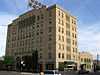
Hotel Baxter |
|
01984-04-19-0000April 19, 1984
(#84002469) |
105 W. Main St.
45°40′46″N 111°04′37″W / 45.679444°N 111.076944°W / 45.679444; -111.076944 (Hotel Baxter) |
Bozeman |
|
| 50 |
House at 22 West Lamme |
|
01987-10-23-0000October 23, 1987
(#87001806) |
22 W. Lamme
45°40′51″N 111°02′14″W / 45.680833°N 111.037222°W / 45.680833; -111.037222 (House at 22 West Lamme) |
Bozeman |
|
| 51 |
House at 714 North Tracy |
|
01988-01-22-0000January 22, 1988
(#87002315) |
714 N. Tracy
45°41′18″N 111°02′09″W / 45.688333°N 111.035833°W / 45.688333; -111.035833 (House at 714 North Tracy) |
Bozeman |
|
| 52 |
House at 818 South Eighth |
Upload image |
01988-01-22-0000January 22, 1988
(#87002318) |
818 S. 8th
45°40′15″N 111°02′02″W / 45.670833°N 111.033889°W / 45.670833; -111.033889 (House at 818 South Eighth) |
Bozeman |
|
| 53 |
Johnson House |
|
01988-01-22-0000January 22, 1988
(#87002321) |
506 N. Bozeman
45°41′02″N 111°15′51″W / 45.683889°N 111.264167°W / 45.683889; -111.264167 (Johnson House) |
Bozeman |
|
| 54 |
Kennedy Building |
|
01983-05-13-0000May 13, 1983
(#83001065) |
127 Yellowstone Ave.
44°39′34″N 111°05′59″W / 44.659444°N 111.099722°W / 44.659444; -111.099722 (Kennedy Building) |
West Yellowstone |
|
| 55 |
Emil Ketterer House |
Upload image |
01983-03-31-0000March 31, 1983
(#83001066) |
35 N. Grand Ave.
45°40′49″N 111°02′21″W / 45.680278°N 111.039167°W / 45.680278; -111.039167 (Emil Ketterer House) |
Bozeman |
|
| 56 |
Kolble House |
Upload image |
01987-10-23-0000October 23, 1987
(#87001812) |
716 S. Black
45°40′22″N 111°02′05″W / 45.672778°N 111.034722°W / 45.672778; -111.034722 (Kolble House) |
Bozeman |
|
| 57 |
Samuel Lewis House |
Upload image |
01999-03-18-0000March 18, 1999
(#99000342) |
308 S. Bozeman Ave.
45°40′33″N 111°01′59″W / 45.675833°N 111.033056°W / 45.675833; -111.033056 (Samuel Lewis House) |
Bozeman |
|
| 58 |
Lindley Place Historic District |
Upload image |
01987-10-23-0000October 23, 1987
(#87001842) |
200-300 Lindley Pl.
45°40′36″N 111°01′57″W / 45.676667°N 111.0325°W / 45.676667; -111.0325 (Lindley Place Historic District) |
Bozeman |
|
| 59 |
Litening Gas |
Upload image |
01987-10-22-0000October 22, 1987
(#87001843) |
424 E. Main
45°40′45″N 111°01′50″W / 45.679167°N 111.030556°W / 45.679167; -111.030556 (Litening Gas) |
Bozeman |
|
| 60 |
Little Bear School |
Upload image |
01982-04-15-0000April 15, 1982
(#82003168) |
Bear Creek Rd.
45°32′46″N 111°09′55″W / 45.546111°N 111.165278°W / 45.546111; -111.165278 (Little Bear School) |
Gallatin Gateway |
|
| 61 |
Lonesomehurst Cabin |
|
02011-08-18-0000August 18, 2011
(#11000541) |
Lonesomehurst Residential Residence Blk. A., Lot 1.
44°44′12″N 111°13′59″W / 44.736667°N 111.233056°W / 44.736667; -111.233056 (Lonesomehurst Cabin) |
West Yellowstone |
|
| 62 |
Lower Bridger School |
Upload image |
01981-07-21-0000July 21, 1981
(#81000347) |
East of Bozeman
45°42′11″N 110°55′44″W / 45.703056°N 110.928889°W / 45.703056; -110.928889 (Lower Bridger School) |
Bozeman |
|
| 63 |
Lower Willow Creek Rural Historic Landscape District |
Upload image |
01993-04-19-0000April 19, 1993
(#93000311) |
Address Restricted
|
Willow Creek |
|
| 64 |
Charles Lundwall Building |
Upload image |
02001-01-04-0000January 4, 2001
(#00001611) |
123-125 W. Main St.
45°40′53″N 111°02′22″W / 45.681389°N 111.039444°W / 45.681389; -111.039444 (Charles Lundwall Building) |
Bozeman |
|
| 65 |
Madison Buffalo Jump State Monument |
|
01970-04-28-0000April 28, 1970
(#70000356) |
7 miles south of Logan
45°47′39″N 111°27′42″W / 45.794167°N 111.461667°W / 45.794167; -111.461667 (Madison Buffalo Jump State Monument) |
Logan |
|
| 66 |
Madison Hotel and Cafe |
|
01983-05-13-0000May 13, 1983
(#83001067) |
137 Yellowstone Ave.
44°39′30″N 111°06′00″W / 44.658333°N 111.1°W / 44.658333; -111.1 (Madison Hotel and Cafe) |
West Yellowstone |
|
| 67 |
Main Street Historic District |
|
01987-12-21-0000December 21, 1987
(#87001848) |
100 block of W. Main through the 300 block of E. Main
45°40′47″N 111°02′05″W / 45.679722°N 111.034722°W / 45.679722; -111.034722 (Main Street Historic District) |
Bozeman |
|
| 68 |
Malmborg School |
Upload image |
01981-07-21-0000July 21, 1981
(#81000349) |
East of Bozeman
45°40′20″N 110°50′06″W / 45.672222°N 110.835°W / 45.672222; -110.835 (Malmborg School) |
Bozeman |
|
| 69 |
Maudlow School |
Upload image |
01982-08-23-0000August 23, 1982
(#82003164) |
Milwaukee Rd.
46°06′27″N 111°10′17″W / 46.1075°N 111.171389°W / 46.1075; -111.171389 (Maudlow School) |
Belgrade |
|
| 70 |
Methodist Episcopal Church |
|
01987-10-23-0000October 23, 1987
(#87001839) |
121 S. Willson
45°40′41″N 111°02′19″W / 45.678056°N 111.038611°W / 45.678056; -111.038611 (Methodist Episcopal Church) |
Bozeman |
|
| 71 |
Methodist Episcopal Church |
Upload image |
02000-12-28-0000December 28, 2000
(#00001566) |
116 Cedar St.
45°53′43″N 111°33′00″W / 45.895278°N 111.55°W / 45.895278; -111.55 (Methodist Episcopal Church) |
Three Forks |
|
| 72 |
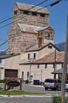
MISCO Grain Elevator |
|
01987-10-23-0000October 23, 1987
(#87001831) |
700 N. Wallace
45°41′15″N 111°01′37″W / 45.6875°N 111.026944°W / 45.6875; -111.026944 (MISCO Grain Elevator) |
Bozeman |
|
| 73 |
Montana State University Historic District |
|
02013-12-24-0000December 24, 2013
(#13000972) |
Roughly bounded by W. College & W. Grant Sts., S. 11th & S. 6th Aves.
45°40′03″N 111°02′58″W / 45.66743°N 111.049355°W / 45.66743; -111.049355 (Montana State University Historic District) |
Bozeman |
|
| 74 |
Newman House |
|
01987-10-23-0000October 23, 1987
(#87001835) |
216 N. Church
45°41′01″N 111°01′44″W / 45.683611°N 111.028889°W / 45.683611; -111.028889 (Newman House) |
Bozeman |
|
| 75 |
North Tracy Avenue Historic District |
|
01987-10-23-0000October 23, 1987
(#87001846) |
300-500 blocks of N. Tracy Ave., Bozeman, and Montana
45°41′04″N 111°02′12″W / 45.684444°N 111.036667°W / 45.684444; -111.036667 (North Tracy Avenue Historic District) |
Bozeman |
|
| 76 |
Northern Pacific-Story Mill Historic District |
Upload image |
01996-05-10-0000May 10, 1996
(#96000479) |
Roughly bounded by the Northern Pacific right-of-way and the Story Mill spur line from Wye to Bridger Canyon Rd.
45°41′30″N 111°01′16″W / 45.691667°N 111.021111°W / 45.691667; -111.021111 (Northern Pacific-Story Mill Historic District) |
Bozeman |
|
| 77 |
Panton House |
Upload image |
01987-10-23-0000October 23, 1987
(#87001828) |
801 S. 7th
45°40′17″N 111°02′00″W / 45.671389°N 111.033333°W / 45.671389; -111.033333 (Panton House) |
Bozeman |
|
| 78 |
Pass Creek School |
Upload image |
01981-07-21-0000July 21, 1981
(#81000341) |
Northeast of Belgrade
45°58′40″N 111°05′52″W / 45.977778°N 111.097778°W / 45.977778; -111.097778 (Pass Creek School) |
Belgrade |
|
| 79 |
Peterson House |
Upload image |
01988-01-22-0000January 22, 1988
(#87002350) |
216 N. Wallace
45°41′00″N 111°01′42″W / 45.683333°N 111.028333°W / 45.683333; -111.028333 (Peterson House) |
Bozeman |
|
| 80 |
Peterson Place |
Upload image |
01993-04-19-0000April 19, 1993
(#93000308) |
Address Restricted
|
Willow Creek |
|
| 81 |
Pine Butte School |
|
01981-07-21-0000July 21, 1981
(#81000351) |
West of Bozeman
45°40′14″N 111°14′54″W / 45.670556°N 111.248333°W / 45.670556; -111.248333 (Pine Butte School) |
Bozeman |
|
| 82 |
Thomas Quaw House |
Upload image |
01991-03-04-0000March 4, 1991
(#91000217) |
5 Central Ave.
45°46′36″N 111°10′27″W / 45.776667°N 111.174167°W / 45.776667; -111.174167 (Thomas Quaw House) |
Belgrade |
|
| 83 |
Rea School |
Upload image |
01981-07-21-0000July 21, 1981
(#81000346) |
West of Bozeman
45°40′19″N 111°07′27″W / 45.671944°N 111.124167°W / 45.671944; -111.124167 (Rea School) |
Bozeman |
|
| 84 |
Reese Creek School |
Upload image |
01981-07-21-0000July 21, 1981
(#81000342) |
Northeast of Belgrade
45°52′29″N 111°04′46″W / 45.874722°N 111.079444°W / 45.874722; -111.079444 (Reese Creek School) |
Belgrade |
|
| 85 |
Rouse House |
Upload image |
01987-10-23-0000October 23, 1987
(#87001832) |
506 E. Babcock
45°40′41″N 111°01′44″W / 45.678056°N 111.028889°W / 45.678056; -111.028889 (Rouse House) |
Bozeman |
|
| 86 |
Ruby Theatre |
Upload image |
01982-04-30-0000April 30, 1982
(#82003169) |
212 Main St.
45°53′35″N 111°33′06″W / 45.893056°N 111.551667°W / 45.893056; -111.551667 (Ruby Theatre) |
Three Forks |
|
| 87 |
Sacajawea Hotel |
|
01980-01-24-0000January 24, 1980
(#80002418) |
5 Main St.
45°53′44″N 111°33′03″W / 45.895556°N 111.550833°W / 45.895556; -111.550833 (Sacajawea Hotel) |
Three Forks |
|
| 88 |
Sedan School |
Upload image |
01981-07-21-0000July 21, 1981
(#81000344) |
Northeast of Belgrade
45°57′30″N 110°51′03″W / 45.958333°N 110.850833°W / 45.958333; -110.850833 (Sedan School) |
Belgrade |
|
| 89 |
South Tracy Avenue Historic District |
|
01987-10-23-0000October 23, 1987
(#87001847) |
802-824 S. Tracy Ave.
45°40′16″N 111°02′14″W / 45.671111°N 111.037222°W / 45.671111; -111.037222 (South Tracy Avenue Historic District) |
Bozeman |
|
| 90 |
South Tracy-South Black Historic District |
|
01987-12-21-0000December 21, 1987
(#87001840) |
200-600 blocks of S. Tracy and S. Black Aves.
45°40′31″N 111°02′11″W / 45.675278°N 111.036389°W / 45.675278; -111.036389 (South Tracy-South Black Historic District) |
Bozeman |
|
| 91 |
South Willson Historic District |
|
01978-12-18-0000December 18, 1978
(#78001687) |
Willson Ave. between Curtiss and Arthur Sts.
45°40′21″N 111°02′19″W / 45.6725°N 111.038611°W / 45.6725; -111.038611 (South Willson Historic District) |
Bozeman |
|
| 92 |
Spanish Creek School |
Upload image |
01981-07-21-0000July 21, 1981
(#81000358) |
Northwest of Gallatin Gateway
45°29′27″N 111°19′50″W / 45.490833°N 111.330556°W / 45.490833; -111.330556 (Spanish Creek School) |
Gallatin Gateway |
|
| 93 |
Spieth and Krug Brewery |
|
01984-04-19-0000April 19, 1984
(#84002473) |
238-246 E. Main St.
45°40′54″N 111°01′53″W / 45.681667°N 111.031389°W / 45.681667; -111.031389 (Spieth and Krug Brewery) |
Bozeman |
|
| 94 |
Spieth Houses |
|
01987-10-23-0000October 23, 1987
(#87001838) |
204 N. Bozeman and 209 E. Lamme
45°40′55″N 111°01′59″W / 45.681944°N 111.033056°W / 45.681944; -111.033056 (Spieth Houses) |
Bozeman |
|
| 95 |
Springhill School |
Upload image |
01981-07-21-0000July 21, 1981
(#81000345) |
Northeast of Belgrade
45°50′21″N 111°02′04″W / 45.839167°N 111.034444°W / 45.839167; -111.034444 (Springhill School) |
Belgrade |
|
| 96 |
St. James Episcopal Church and Rectory |
|
01987-10-23-0000October 23, 1987
(#87001841) |
9 W. Olive
45°40′40″N 111°02′12″W / 45.677778°N 111.036667°W / 45.677778; -111.036667 (St. James Episcopal Church and Rectory) |
Bozeman |
|
| 97 |
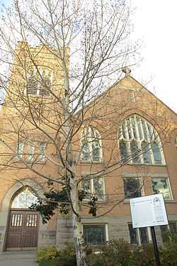
Stateler Memorial Methodist Church |
Upload image |
02008-07-29-0000July 29, 2008
(#08000757) |
303 Main St.
45°49′32″N 111°38′42″W / 45.8256°N 111.64495°W / 45.8256; -111.64495 (Stateler Memorial Methodist Church) |
Willow Creek |
|
| 98 |
Story Motor Company |
Upload image |
01987-10-23-0000October 23, 1987
(#87001837) |
202 W. Main
45°40′47″N 111°02′21″W / 45.679722°N 111.039167°W / 45.679722; -111.039167 (Story Motor Company) |
Bozeman |
|
| 99 |
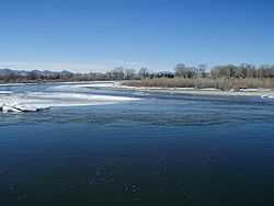
Three Forks of the Missouri |
|
01966-10-15-0000October 15, 1966
(#66000433) |
Northeast of Three Forks on the Missouri River, at Missouri Headwaters State Monument
45°55′48″N 111°30′00″W / 45.930000°N 111.500000°W / 45.930000; -111.500000 (Three Forks of the Missouri) |
Three Forks |
|
| 100 |
Three Valleys State Bank |
Upload image |
02005-04-11-0000April 11, 2005
(#05000256) |
202 Main St.
45°53′35″N 111°33′07″W / 45.893056°N 111.551944°W / 45.893056; -111.551944 (Three Valleys State Bank) |
Three Forks |
|
| 101 |
Trident School |
Upload image |
01981-07-21-0000July 21, 1981
(#81000364) |
South of Trident
45°56′58″N 111°28′24″W / 45.949444°N 111.473333°W / 45.949444; -111.473333 (Trident School) |
Trident |
|
| 102 |
Upper Madison School |
Upload image |
01983-01-19-0000January 19, 1983
(#83001068) |
Buffalo Jump Rd.
45°44′38″N 111°28′07″W / 45.743889°N 111.468611°W / 45.743889; -111.468611 (Upper Madison School) |
Three Forks |
|
| 103 |
Watkins Creek Ranch |
|
02006-12-27-0000December 27, 2006
(#06001180) |
1207 Firehole Ranch Rd.
44°48′49″N 111°17′20″W / 44.8137°N 111.288858°W / 44.8137; -111.288858 (Watkins Creek Ranch) |
West Yellowstone |
|
| 104 |
West Yellowstone Oregon Shortline Terminus Historic District |
|
01983-04-13-0000April 13, 1983
(#83001069) |
Yellowstone Ave.
44°39′30″N 111°06′06″W / 44.658333°N 111.101667°W / 44.658333; -111.101667 (West Yellowstone Oregon Shortline Terminus Historic District) |
West Yellowstone |
|

_-_Gallatin_County%2C_Montana.png)

_-_Gallatin_County%2C_Montana.png)
_-_Jefferson_County%2C_Montana.png)
_-_Galltin_County%2C_Montana.png)