National Register of Historic Places listings in Gadsden County, Florida

Location of Gadsden County in Florida
This is a list of the National Register of Historic Places listings in Gadsden County, Florida.
This is intended to be a complete list of the properties and districts on the National Register of Historic Places in Gadsden County, Florida, United States. The locations of National Register properties and districts for which the latitude and longitude coordinates are included below, may be seen in a Google map.[1]
There are 16 properties and districts listed on the National Register in the county.
- This National Park Service list is complete through NPS recent listings posted May 1, 2015.[2]
Current listings
| [3] |
Name on the Register[4] |
Image |
Date listed[5] |
Location |
City or town |
Description |
|---|
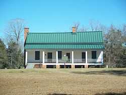
| 1 |
Joshua Davis House |
|
01975-05-21-0000May 21, 1975
(#75000554) |
2½ miles northwest of Mt. Pleasant on U.S. Route 90
30°41′19″N 84°43′20″W / 30.688611°N 84.722222°W / 30.688611; -84.722222 (Joshua Davis House) |
Mount Pleasant |
|
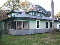
| 2 |
Dezell House |
|
02006-05-10-0000May 10, 2006
(#06000358) |
328 East 8th Street
30°34′00″N 84°44′38″W / 30.566611°N 84.743889°W / 30.566611; -84.743889 (Dezell House) |
Greensboro |
|
| 3 |
Willoughby Gregory House |
|
01983-12-16-0000December 16, 1983
(#83003520) |
Highway 274 and Krausland Road
30°33′29″N 84°36′43″W / 30.558056°N 84.611944°W / 30.558056; -84.611944 (Willoughby Gregory House) |
Quincy |
|
| 4 |
Gretna School |
|
02008-06-10-0000June 10, 2008
(#08000502) |
722 Church Street
30°37′01″N 84°39′10″W / 30.616944°N 84.652694°W / 30.616944; -84.652694 (Gretna School) |
Gretna |
|
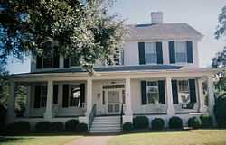
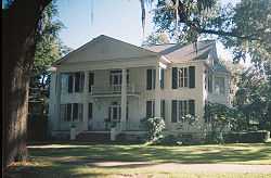
| 5 |
E. C. Love House |
|
01974-12-30-0000December 30, 1974
(#74000626) |
219 North Jackson Street
30°35′26″N 84°34′45″W / 30.590556°N 84.579167°W / 30.590556; -84.579167 (E. C. Love House) |
Quincy |
|
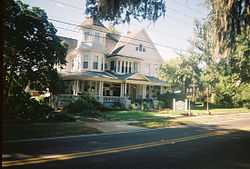
| 6 |
John Lee McFarlin House |
|
01974-12-27-0000December 27, 1974
(#74000627) |
305 East King Street
30°35′26″N 84°34′22″W / 30.590556°N 84.572778°W / 30.590556; -84.572778 (John Lee McFarlin House) |
Quincy |
|
| 7 |
Dr. Malcolm Nicholson Farmhouse |
|
01994-10-28-0000October 28, 1994
(#94001272) |
Northern side of State Road 12, west of Havana
30°36′39″N 84°28′14″W / 30.610833°N 84.470556°W / 30.610833; -84.470556 (Dr. Malcolm Nicholson Farmhouse) |
Havana |
|
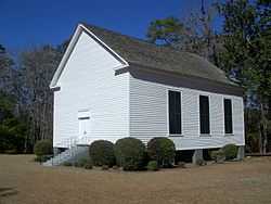
| 8 |
Old Philadelphia Presbyterian Church |
|
01975-02-24-0000February 24, 1975
(#75000557) |
5 miles north of Quincy off State Road 65
30°38′37″N 84°34′38″W / 30.643611°N 84.577222°W / 30.643611; -84.577222 (Old Philadelphia Presbyterian Church) |
Quincy |
|
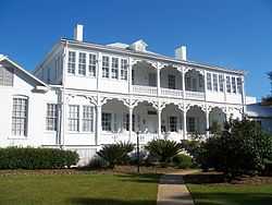
| 9 |
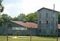
Planter's Exchange, Inc. |
|
01999-09-17-0000September 17, 1999
(#99001147) |
204 Second Street, Northwest
30°37′28″N 84°25′02″W / 30.624444°N 84.417222°W / 30.624444; -84.417222 (Planter's Exchange, Inc.) |
Havana |
|
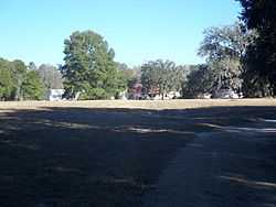
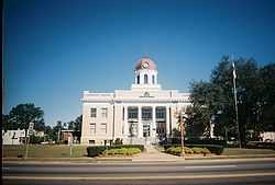
| 10 |
Quincy Historic District |
|
01978-11-09-0000November 9, 1978
(#78000942) |
Roughly bounded by Sharon, Clark, Stewart, and Corry Streets
30°35′28″N 84°34′30″W / 30.591111°N 84.575°W / 30.591111; -84.575 (Quincy Historic District) |
Quincy |
|
| 11 |
Quincy Library |
|
01974-09-09-0000September 9, 1974
(#74000628) |
303 North Adams Street
30°35′28″N 84°34′37″W / 30.591111°N 84.576944°W / 30.591111; -84.576944 (Quincy Library) |
Quincy |
|
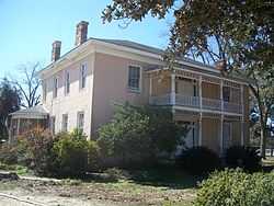
| 12 |
Quincy Woman's Club |
|
01975-03-10-0000March 10, 1975
(#75000555) |
300 North Calhoun Street
30°35′27″N 84°34′51″W / 30.590833°N 84.580833°W / 30.590833; -84.580833 (Quincy Woman's Club) |
Quincy |
|
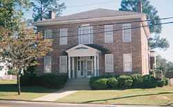
| 13 |
E. B. Shelfer House |
|
01975-04-04-0000April 4, 1975
(#75000556) |
205 North Madison Street
30°35′25″N 84°34′31″W / 30.590278°N 84.575278°W / 30.590278; -84.575278 (E. B. Shelfer House) |
Quincy |
|
| 14 |
Stockton-Curry House |
|
01974-12-31-0000December 31, 1974
(#74000629) |
121 North Duval Street
30°35′23″N 84°34′28″W / 30.589722°N 84.574444°W / 30.589722; -84.574444 (Stockton-Curry House) |
Quincy |
|
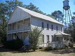
| 15 |
U.S. Arsenal-Officers Quarters |
|
01973-07-02-0000July 2, 1973
(#73000578) |
Florida State Hospital, U.S. Route 90
30°42′24″N 84°50′12″W / 30.706667°N 84.836667°W / 30.706667; -84.836667 (U.S. Arsenal-Officers Quarters) |
Chattahoochee |
|
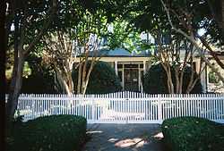
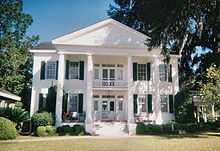
| 16 |
Judge P. W. White House |
|
01972-12-05-0000December 5, 1972
(#72000319) |
212 North Madison Street
30°35′27″N 84°34′34″W / 30.590833°N 84.576111°W / 30.590833; -84.576111 (Judge P. W. White House) |
Quincy |
|
Former listings
| [3] |
Name on the Register |
Image |
Date listed | Date removed |
Location |
City or town |
Summary |
|---|
| 1 |
Malachi Martin House |
Upload image |
01976-08-11-0000August 11, 1976
(#76000597) | 01989-06-02-0000June 2, 1989 |
5 mi. E of Chattahoochee off U.S. 90
|
Chattahoochee vicinity |
|
See also
References
- ↑ The latitude and longitude information provided in this table was derived originally from the National Register Information System, which has been found to be fairly accurate for about 99% of listings. For about 1% of NRIS original coordinates, experience has shown that one or both coordinates are typos or otherwise extremely far off; some corrections may have been made. A more subtle problem causes many locations to be off by up to 150 yards, depending on location in the country: most NRIS coordinates were derived from tracing out latitude and longitudes off of USGS topographical quadrant maps created under the North American Datum of 1927, which differs from the current, highly accurate WGS84 GPS system used by most on-line maps. Chicago is about right, but NRIS longitudes in Washington are higher by about 4.5 seconds, and are lower by about 2.0 seconds in Maine. Latitudes differ by about 1.0 second in Florida. Some locations in this table may have been corrected to current GPS standards.
- ↑ "National Register of Historic Places: Weekly List Actions". National Park Service, United States Department of the Interior. Retrieved on May 1, 2015.
- ↑ 3.0 3.1 Numbers represent an ordering by significant words. Various colorings, defined here, differentiate National Historic Landmarks and historic districts from other NRHP buildings, structures, sites or objects.
- ↑ "National Register Information System". National Register of Historic Places. National Park Service. 2009-03-13.
- ↑ The eight-digit number below each date is the number assigned to each location in the National Register Information System database, which can be viewed by clicking the number.
|
|---|
| | Lists by county | | |
|---|
| | Lists by city | |
|---|
| | Other lists | |
|---|
| |
|