National Register of Historic Places listings in Fremont County, Idaho
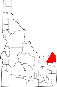
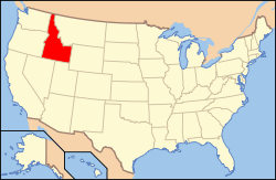
Location of Fremont County in Idaho
This is a list of the National Register of Historic Places listings in Fremont County, Idaho.
This is intended to be a complete list of the properties and districts on the National Register of Historic Places in Fremont County, Idaho, United States. Latitude and longitude coordinates are provided for many National Register properties and districts; these locations may be seen together in a Google map.[1]
There are 12 properties and districts listed on the National Register in the county. More may be added; properties and districts nationwide are added to the Register weekly.[2]
- This National Park Service list is complete through NPS recent listings posted May 1, 2015.[3]
Current listings
| [4] | Name on the Register[5] | Image | Date listed[6] | Location | City or town | Description |
|---|---|---|---|---|---|---|
| 1 | Big Falls Inn | 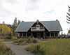 |
(#94000131) |
Western bank of Henrys Fork at Upper Mesa Falls in the Targhee National Forest 44°11′16″N 111°19′37″W / 44.187778°N 111.326944°W |
Island Park | |
| 2 | Bishop Mountain Lookout | 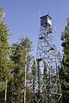 |
(#86001184) |
Forest Rd. 80120 44°20′03″N 111°33′09″W / 44.334167°N 111.5525°W |
Island Park | |
| 3 | Conant Creek Pegram Truss Railroad Bridge | 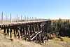 |
(#97000756) |
Over the Conant Creek, 1 mile south of the junction of Squirrel Rd. and old Ashton-Victor railroad spur tracks 44°00′52″N 111°21′51″W / 44.014444°N 111.364167°W |
Grainville | |
| 4 | Glen and Addie Crabtree Cabin | Upload image | (#00000742) |
3939 Cowan Rd. 44°27′27″N 111°26′22″W / 44.4575°N 111.439444°W |
Island Park | |
| 5 | Fremont County Courthouse | 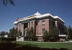 |
(#79000789) |
151 W. 1st St., N. 43°58′04″N 111°41′01″W / 43.967778°N 111.683611°W |
St. Anthony | |
| 6 | Idaho State Industrial School Women's Dormitory | 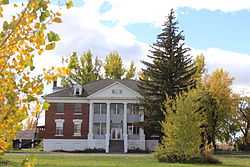 |
(#82000344) |
2266 E. 600 North 43°58′10″N 111°42′16″W / 43.969444°N 111.704444°W |
St. Anthony | |
| 7 | Independent Order of Odd Fellows Hall | 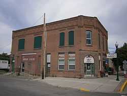 |
(#97000763) |
601 Main St. 44°04′18″N 111°26′49″W / 44.071667°N 111.447083°W |
Ashton | |
| 8 | Island Park Land and Cattle Company Home Ranch | 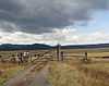 |
(#96001508) |
U.S. Route 20, approximately 1 mile southwest of Island Park 44°20′41″N 111°27′39″W / 44.344722°N 111.460833°W |
Island Park | |
| 9 | Johnny Sack Cabin |  |
(#79000788) |
Island Park 44°30′01″N 111°15′15″W / 44.500278°N 111.254167°W |
Island Park | |
| 10 | St. Anthony Pegram Truss Railroad Bridge | 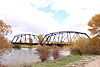 |
(#97000761) |
Over Henry's Fork, 0.5 miles south of the junction of S. Parker Rd. and West Belt Branch railroad tracks 43°57′01″N 111°42′59″W / 43.950278°N 111.716389°W |
St. Anthony | |
| 11 | Joseph Sherwood House and Store | 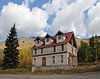 |
(#94001452) |
State Highway 87 west of its junction with U.S. Route 20 44°39′57″N 111°23′08″W / 44.665833°N 111.385556°W |
Island Park | |
| 12 | US Post Office-St. Anthony Main | 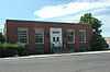 |
(#89000136) |
48 W. 1st, N. 43°58′02″N 111°40′57″W / 43.967222°N 111.6825°W |
St. Anthony |
See also
| Wikimedia Commons has media related to National Register of Historic Places in Fremont County, Idaho. |
References
- ↑ The latitude and longitude information provided in this table was derived originally from the National Register Information System, which has been found to be fairly accurate for about 99% of listings. For about 1% of NRIS original coordinates, experience has shown that one or both coordinates are typos or otherwise extremely far off; some corrections may have been made. A more subtle problem causes many locations to be off by up to 150 yards, depending on location in the country: most NRIS coordinates were derived from tracing out latitude and longitudes off of USGS topographical quadrant maps created under the North American Datum of 1927, which differs from the current, highly accurate WGS84 GPS system used by most on-line maps. Chicago is about right, but NRIS longitudes in Washington are higher by about 4.5 seconds, and are lower by about 2.0 seconds in Maine. Latitudes differ by about 1.0 second in Florida. Some locations in this table may have been corrected to current GPS standards.
- ↑ "National Register of Historic Places: Weekly List Actions". National Park Service. Retrieved March 29, 2009.
- ↑ "National Register of Historic Places: Weekly List Actions". National Park Service, United States Department of the Interior. Retrieved on May 1, 2015.
- ↑ Numbers represent an ordering by significant words. Various colorings, defined here, differentiate National Historic Landmarks and historic districts from other NRHP buildings, structures, sites or objects.
- ↑ "National Register Information System". National Register of Historic Places. National Park Service. 2008-04-24.
- ↑ The eight-digit number below each date is the number assigned to each location in the National Register Information System database, which can be viewed by clicking the number.

| ||||||||||||||||||||||||||
| |||||||||||||||||