National Register of Historic Places listings in Ford County, Kansas

Location of Ford County in Kansas
This is a list of the National Register of Historic Places listings in Ford County, Kansas.
This is intended to be a complete list of the properties on the National Register of Historic Places in Ford County, Kansas, United States. The locations of National Register properties for which the latitude and longitude coordinates are included below, may be seen in a Google map.[1]
There are 11 properties listed on the National Register in the county.
- This National Park Service list is complete through NPS recent listings posted May 1, 2015.[2]
Current listings
| [3] | Name on the Register[4] | Image | Date listed[5] | Location | City or town | Description |
|---|---|---|---|---|---|---|
| 1 | Atchison, Topeka and Santa Fe Railway Depot | 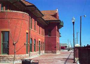 |
(#00000791) |
E. Wyatt Earp Boulevard 37°45′20″N 100°00′46″W / 37.755556°N 100.012778°W |
Dodge City | |
| 2 | Burr House | 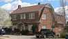 |
(#07001481) |
603 W. Spruce 37°45′16″N 100°01′22″W / 37.754453°N 100.022788°W |
Dodge City | |
| 3 | Dodge City Downtown Historic District | 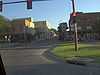 |
(#09000875) |
Roughly bounded by Front St. on the south, 3rd Ave. on the west, Vine St. on the north, and Central Ave. on the east 37°45′14″N 100°01′07″W / 37.753933°N 100.018544°W |
Dodge City | |
| 4 | Dodge City Municipal Building | 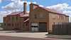 |
(#13000217) |
501 W. Spruce St. 37°45′16″N 100°01′19″W / 37.754355°N 100.021927°W |
Dodge City | |
| 5 | Dodge City Public Library | 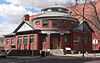 |
(#79000954) |
2nd and Spruce Aves. 37°45′17″N 100°01′10″W / 37.754589°N 100.019314°W |
Dodge City | |
| 6 | Hennessy Hall, Saint Mary of the Plains Campus | _W_end_from_S_2.JPG) |
(#03001396) |
240 San Jose Dr. 37°46′35″N 100°00′39″W / 37.776265°N 100.010767°W |
Dodge City | |
| 7 | Immaculate Heart of Mary Catholic Church | 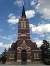 |
(#88003087) |
Southeast of Spearville 37°47′06″N 99°38′28″W / 37.785°N 99.641111°W |
Windthorst | |
| 8 | Lora Locke Hotel | 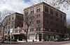 |
(#85000012) |
Central and Gunsmoke Sts. 37°45′13″N 100°01′02″W / 37.753664°N 100.017241°W |
Dodge City | |
| 9 | Mueller-Schmidt House | 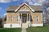 |
(#72000499) |
112 E. Vine St. 37°45′20″N 100°00′56″W / 37.75557°N 100.015546°W |
Dodge City | |
| 10 | Sacred Heart Cathedral | _from_SE_1.JPG) |
(#83000426) |
903 Central Ave. 37°45′23″N 100°01′01″W / 37.756478°N 100.016989°W |
Dodge City | |
| 11 | Santa Fe Trail-Ford County Segment 2 |  |
(#13000488) |
SW. corner of Ridge & 129th Rds. 37°39′33″N 99°41′48″W / 37.659178°N 99.696570°W |
Ford | Santa Fe Trail Multiple Property Submission |
| 12 | Sante Fe Trail Ruts |  |
(#66000343) |
9 miles west of Dodge City on U.S. Route 50 37°47′31″N 100°11′49″W / 37.791944°N 100.196944°W |
Dodge City | |
| 13 | Sawlog Creek Crossing on the Fort Hayes-Fort Dodge Road | Upload image | (#13000489) |
Address Restricted |
Spearville | Santa Fe Trail Multiple Property Submission |
See also
| Wikimedia Commons has media related to National Register of Historic Places in Ford County, Kansas. |
- List of National Historic Landmarks in Kansas
- National Register of Historic Places listings in Kansas
References
- ↑ The latitude and longitude information provided in this table was derived originally from the National Register Information System, which has been found to be fairly accurate for about 99% of listings. For about 1% of NRIS original coordinates, experience has shown that one or both coordinates are typos or otherwise extremely far off; some corrections may have been made. A more subtle problem causes many locations to be off by up to 150 yards, depending on location in the country: most NRIS coordinates were derived from tracing out latitude and longitudes off of USGS topographical quadrant maps created under the North American Datum of 1927, which differs from the current, highly accurate WGS84 GPS system used by most on-line maps. Chicago is about right, but NRIS longitudes in Washington are higher by about 4.5 seconds, and are lower by about 2.0 seconds in Maine. Latitudes differ by about 1.0 second in Florida. Some locations in this table may have been corrected to current GPS standards.
- ↑ "National Register of Historic Places: Weekly List Actions". National Park Service, United States Department of the Interior. Retrieved on May 1, 2015.
- ↑ Numbers represent an ordering by significant words. Various colorings, defined here, differentiate National Historic Landmarks and historic districts from other NRHP buildings, structures, sites or objects.
- ↑ "National Register Information System". National Register of Historic Places. National Park Service. 2009-03-13.
- ↑ The eight-digit number below each date is the number assigned to each location in the National Register Information System database, which can be viewed by clicking the number.


| |||||||||||||||||||||||||