National Register of Historic Places listings in Flagler County, Florida

Location of Flagler County in Florida
This is a list of the National Register of Historic Places listings in Flagler County, Florida.
This is intended to be a complete list of the properties and districts on the National Register of Historic Places in Flagler County, Florida, United States. The locations of National Register properties and districts for which the latitude and longitude coordinates are included below, may be seen in a Google map.[1]
There are 8 properties and districts listed on the National Register in the county.
- This National Park Service list is complete through NPS recent listings posted May 1, 2015.[2]
Current listings
| [3] |
Name on the Register[4] |
Image |
Date listed[5] |
Location |
City or town |
Description |
|---|
| 1 |
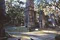
Bulow Plantation Ruins |
|
01970-09-29-0000September 29, 1970
(#70000185) |
Address Restricted
29°26′10″N 81°08′28″W / 29.436111°N 81.141111°W / 29.436111; -81.141111 (Bulow Plantation Ruins) |
Bunnell |
|
| 2 |
Cherokee Grove |
|
01997-05-02-0000May 2, 1997
(#97000379) |
West of State Road A1A and east of Interstate 95, on Pellicer Creek, approximately ¼ mile south of the St. Johns-Flagler county line
29°39′30″N 81°14′15″W / 29.658333°N 81.2375°W / 29.658333; -81.2375 (Cherokee Grove) |
Bunnell |
|
| 3 |
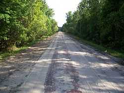
Dixie Highway-Hastings, Espanola and Bunnell Road |
|
02005-04-20-0000April 20, 2005
(#05000311) |
Roughly Espanola in Flagler County to County Route 204 in St. Johns County
29°34′49″N 81°20′35″W / 29.580278°N 81.343056°W / 29.580278; -81.343056 (Dixie Highway-Hastings, Espanola and Bunnell Road) |
Espanola |
Extends into St. Johns County
|
| 4 |
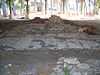
Mala Compra Plantation Archeological Site |
|
02004-03-05-0000March 5, 2004
(#04000142) |
Approximately 1000 feet west of the intersection of North Oceanshore Boulevard and Mala Compra Drive
29°36′54″N 81°12′14″W / 29.615°N 81.203889°W / 29.615; -81.203889 (Mala Compra Plantation Archeological Site) |
Palm Coast |
|
| 5 |
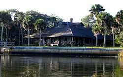
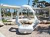
Marine Studios |
|
01986-04-14-0000April 14, 1986
(#86000831) |
State Road A1A, Box 122
29°40′06″N 81°12′46″W / 29.668333°N 81.212778°W / 29.668333; -81.212778 (Marine Studios) |
Marineland |
|
| 6 |
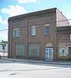
Old Bunnell State Bank Building |
|
01992-06-25-0000June 25, 1992
(#92000824) |
101-107 North Bay Street
29°27′53″N 81°15′32″W / 29.464722°N 81.258889°W / 29.464722; -81.258889 (Old Bunnell State Bank Building) |
Bunnell |
|
| 7 |
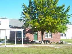
Vocational Agriculture Building |
|
02007-02-21-0000February 21, 2007
(#07000058) |
1001 East Howe Street
29°28′19″N 81°15′17″W / 29.471944°N 81.254722°W / 29.471944; -81.254722 (Vocational Agriculture Building) |
Bunnell |
Part of the Florida's New Deal Resources MPS
|
| 8 |
Washington Oaks Historic District |
|
02009-09-30-0000September 30, 2009
(#09000400) |
6402 Oceanshore Boulevard
29°38′06″N 81°12′14″W / 29.635°N 81.203889°W / 29.635; -81.203889 (Washington Oaks Historic District) |
Palm Coast |
|
See also
References
- ↑ The latitude and longitude information provided in this table was derived originally from the National Register Information System, which has been found to be fairly accurate for about 99% of listings. For about 1% of NRIS original coordinates, experience has shown that one or both coordinates are typos or otherwise extremely far off; some corrections may have been made. A more subtle problem causes many locations to be off by up to 150 yards, depending on location in the country: most NRIS coordinates were derived from tracing out latitude and longitudes off of USGS topographical quadrant maps created under the North American Datum of 1927, which differs from the current, highly accurate WGS84 GPS system used by most on-line maps. Chicago is about right, but NRIS longitudes in Washington are higher by about 4.5 seconds, and are lower by about 2.0 seconds in Maine. Latitudes differ by about 1.0 second in Florida. Some locations in this table may have been corrected to current GPS standards.
- ↑ "National Register of Historic Places: Weekly List Actions". National Park Service, United States Department of the Interior. Retrieved on May 1, 2015.
- ↑ Numbers represent an ordering by significant words. Various colorings, defined here, differentiate National Historic Landmarks and historic districts from other NRHP buildings, structures, sites or objects.
- ↑ "National Register Information System". National Register of Historic Places. National Park Service. 2009-03-13.
- ↑ The eight-digit number below each date is the number assigned to each location in the National Register Information System database, which can be viewed by clicking the number.
|
|---|
| | Lists by county | | |
|---|
| | Lists by city | |
|---|
| | Other lists | |
|---|
| |
|