| [3] |
Name on the Register[4] |
Image |
Date listed[5] |
Location |
City or town |
Description |
|---|
| 1 |
Abraham Lincoln Statue and Park |
Upload image |
02000-10-30-0000October 30, 2000
(#00001197) |
Junction of Mill and Stone
43°00′13″N 91°39′53″W / 43.003611°N 91.664722°W / 43.003611; -91.664722 (Abraham Lincoln Statue and Park) |
Clermont |
|
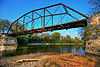
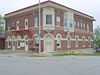
| 2 |
Bigler Building |
|
01995-06-09-0000June 9, 1995
(#95000691) |
210 Mill St.
43°00′01″N 91°39′22″W / 43.000278°N 91.656111°W / 43.000278; -91.656111 (Bigler Building) |
Clermont |
|
| 3 |
Chicago, Milwaukee, St. Paul and Pacific Railroad Company Depot |
Upload image |
01978-12-28-0000December 28, 1978
(#78001219) |
Northeast of Fayette off Iowa Highway 150
42°52′16″N 91°46′59″W / 42.871111°N 91.783056°W / 42.871111; -91.783056 (Chicago, Milwaukee, St. Paul and Pacific Railroad Company Depot) |
Fayette |
|
| 4 |
Church of the Saviour Episcopal Church and David Henderson Statue |
Upload image |
02000-10-30-0000October 30, 2000
(#00001196) |
Junction of Mill and Thompson
43°00′10″N 91°39′14″W / 43.002778°N 91.653889°W / 43.002778; -91.653889 (Church of the Saviour Episcopal Church and David Henderson Statue) |
Clermont |
|
| 5 |
Clermont Public School |
Upload image |
01995-11-22-0000November 22, 1995
(#95001316) |
505 Larrabee St.
42°59′48″N 91°39′11″W / 42.996667°N 91.653056°W / 42.996667; -91.653056 (Clermont Public School) |
Clermont |
|
| 6 |
College Hall |
Upload image |
01976-11-07-0000November 7, 1976
(#76000770) |
200 block of E. Clark
42°50′30″N 91°48′07″W / 42.841667°N 91.801944°W / 42.841667; -91.801944 (College Hall) |
Fayette |
|
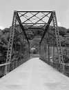
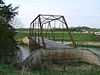
| 7 |
Eldorado Bridge |
|
01998-06-25-0000June 25, 1998
(#98000783) |
State St. over the Turkey River
43°03′13″N 91°50′05″W / 43.053611°N 91.834722°W / 43.053611; -91.834722 (Eldorado Bridge) |
Eldorado |
|
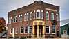
| 8 |
The Elgin Block |
Upload image |
02008-05-08-0000May 8, 2008
(#08000374) |
225-231 Center St.
42°57′26″N 91°37′37″W / 42.95735°N 91.62687°W / 42.95735; -91.62687 (The Elgin Block) |
Eldorado |
|
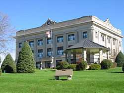
| 9 |
Fayette County Courthouse |
|
01981-07-02-0000July 2, 1981
(#81000236) |
Pine St.
42°57′38″N 91°48′21″W / 42.960556°N 91.805833°W / 42.960556; -91.805833 (Fayette County Courthouse) |
West Union |
|
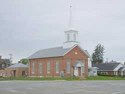
| 10 |
First Baptist Church of West Union |
|
01999-10-07-0000October 7, 1999
(#99001240) |
Main and Vine Sts.
42°57′46″N 91°48′31″W / 42.962853°N 91.80856°W / 42.962853; -91.80856 (First Baptist Church of West Union) |
West Union |
|
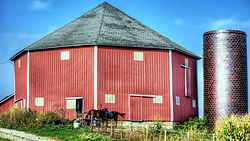
| 11 |
Grimes Octagon Barn |
|
01986-06-30-0000June 30, 1986
(#86001428) |
Off Iowa Highway 56
42°56′10″N 91°45′01″W / 42.936111°N 91.750278°W / 42.936111; -91.750278 (Grimes Octagon Barn) |
West Union |
|
| 12 |
Alfred Hanson House |
Upload image |
01984-07-12-0000July 12, 1984
(#84001252) |
403 N. Frederick Ave.
42°41′01″N 91°54′46″W / 42.683611°N 91.912778°W / 42.683611; -91.912778 (Alfred Hanson House) |
Oelwein |
|
| 13 |
Hardware Building |
Upload image |
01977-07-15-0000July 15, 1977
(#77000516) |
223 Mill St.
42°50′23″N 91°39′25″W / 42.839722°N 91.656944°W / 42.839722; -91.656944 (Hardware Building) |
Wadena |
|
| 14 |
Hotel Mealey |
Upload image |
01983-01-27-0000January 27, 1983
(#83000357) |
102 S. Frederick Ave.
42°40′37″N 91°54′49″W / 42.676944°N 91.913611°W / 42.676944; -91.913611 (Hotel Mealey) |
Oelwein |
|
| 15 |
Maple View Sanitarium |
|
01998-07-21-0000July 21, 1998
(#98000866) |
100 N. Walnut St.
42°57′41″N 91°48′22″W / 42.961496°N 91.806053°W / 42.961496; -91.806053 (Maple View Sanitarium) |
West Union |
|
| 16 |
Maynard Town Hall and Jail |
Upload image |
01997-10-30-0000October 30, 1997
(#97001286) |
330 Main St., W.
42°46′42″N 91°53′11″W / 42.778333°N 91.886389°W / 42.778333; -91.886389 (Maynard Town Hall and Jail) |
Maynard |
|
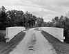
| 17 |
Mill Race Bridge |
|
01998-06-25-0000June 25, 1998
(#98000784) |
Pheasant Rd. over the Turkey River
43°04′39″N 91°53′21″W / 43.077491°N 91.889045°W / 43.077491; -91.889045 (Mill Race Bridge) |
Northwest of Eldorado, Iowa |
|
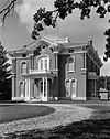
| 18 |
Montauk |
|
01973-02-21-0000February 21, 1973
(#73000725) |
1 mile northeast of Clermont on U.S. Route 18
43°00′49″N 91°38′25″W / 43.013611°N 91.640278°W / 43.013611; -91.640278 (Montauk) |
Clermont |
|
| 19 |
August Nus Polygonal Barn |
Upload image |
01986-06-30-0000June 30, 1986
(#86001427) |
County Road C2, W.
42°45′35″N 91°38′23″W / 42.759722°N 91.639722°W / 42.759722; -91.639722 (August Nus Polygonal Barn) |
Arlington |
|
| 20 |
Otter Creek Bridge |
Upload image |
01998-06-25-0000June 25, 1998
(#98000781) |
40th St. over Otter Creek
42°41′10″N 91°56′49″W / 42.686111°N 91.946944°W / 42.686111; -91.946944 (Otter Creek Bridge) |
Oelwein |
|
| 21 |
St. Luke's School and Recreation Center |
Upload image |
02005-08-24-0000August 24, 2005
(#05000899) |
212 East Main
43°04′01″N 91°55′49″W / 43.066944°N 91.930278°W / 43.066944; -91.930278 (St. Luke's School and Recreation Center) |
St. Lucas |
|
| 22 |
Stoe Creek Bridge |
Upload image |
01998-06-25-0000June 25, 1998
(#98000782) |
V Ave. over Stoe Creek
42°47′30″N 92°00′08″W / 42.791667°N 92.002222°W / 42.791667; -92.002222 (Stoe Creek Bridge) |
Oelwein |
|
| 23 |
Sumner Bridge |
Upload image |
01998-06-25-0000June 25, 1998
(#98000785) |
160th St. over the Little Wapsipinicon River
43°04′39″N 91°53′21″W / 43.0775°N 91.889167°W / 43.0775; -91.889167 (Sumner Bridge) |
Sumner |
|
| 24 |
Twin Bridge |
|
01998-06-25-0000June 25, 1998
(#98000779) |
130th St. over the Little Volga River
42°50′04″N 91°51′53″W / 42.834444°N 91.864722°W / 42.834444; -91.864722 (Twin Bridge) |
Fayette |
|
| 25 |
Union Sunday School |
|
01974-11-05-0000November 5, 1974
(#74000785) |
McGregor and Larrabee Sts.
43°00′10″N 91°39′25″W / 43.002778°N 91.656944°W / 43.002778; -91.656944 (Union Sunday School) |
Clermont |
|
| 26 |
Vine Street Bridge |
|
01998-06-25-0000June 25, 1998
(#98000780) |
South Vine St. over Otter Creek
42°57′16″N 91°48′29″W / 42.954494°N 91.808042°W / 42.954494; -91.808042 (Vine Street Bridge) |
West Union |
|
| 27 |
West Auburn Bridge |
|
01998-06-25-0000June 25, 1998
(#98000786) |
Near Neon Rd. over the Turkey River
43°00′59″N 91°52′43″W / 43.016389°N 91.878611°W / 43.016389; -91.878611 (West Auburn Bridge) |
West Union |
|

.jpg)