National Register of Historic Places listings in Faulkner County, Arkansas
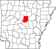
Location of Faulkner County in Arkansas
This is a list of the National Register of Historic Places listings in Faulkner County, Arkansas.
This is intended to be a complete list of the properties and districts on the National Register of Historic Places in Faulkner County, Arkansas, United States. The locations of National Register properties and districts for which the latitude and longitude coordinates are included below, may be seen in a Google map.[1]
There are 62 properties and districts listed on the National Register in the county. Three sites that were once listed have been removed.
- This National Park Service list is complete through NPS recent listings posted May 1, 2015.[2]
Current listings
| [3] | Name on the Register[4] | Image | Date listed[5] | Location | City or town | Description |
|---|---|---|---|---|---|---|
| 1 | Administration Building, University of Central Arkansas | 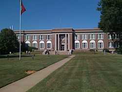 |
(#10001153) |
201 Donaghey Ave. 35°04′45″N 92°27′26″W / 35.079167°N 92.457222°W |
Conway | New Deal Recovery Efforts in Arkansas Multiple Property Submission (MPS) |
| 2 | Blessing Farmstead | Upload image | (#90001369) |
North of Enola 35°15′08″N 92°14′30″W / 35.252222°N 92.241667°W |
Barney | |
| 3 | Brown House | 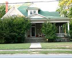 |
(#82000811) |
1604 Caldwell St. 35°05′24″N 92°26′44″W / 35.09°N 92.445556°W |
Conway | part of the Charles L. Thompson Design Collection Thematic Resource (TR) |
| 4 | Cadron Settlement | Upload image | (#74000475) |
Address Restricted |
Conway | A Trail of Tears site[6] |
| 5 | Castleberry-Harrington Historic District | Upload image | (#07000503) |
Castleberry Rd. 35°15′36″N 92°25′36″W / 35.26°N 92.426667°W |
Republican | part of the Mixed Masonry Buildings of Silas Owens, Sr. MPS |
| 6 | Century Flyer | Upload image | (#10000284) |
150 E. Siebenmorgan Rd. 35°05′56″N 92°25′45″W / 35.098889°N 92.429167°W |
Conway | Amusement park train on the grounds of the Conway Human Development Center |
| 7 | Church of Christ | Upload image | (#05000040) |
Highway 310 35°19′33″N 92°20′07″W / 35.325833°N 92.335278°W |
Guy | part of the Mixed Masonry Buildings of Silas Owens, Sr. MPS |
| 8 | Conway Commercial Historic District | Upload image | (#10000779) |
Roughly bounded by Main St. on the south, Harkrider St. and Spencer St. on the east, just south of Mill St. to the north, and Locust St. 35°05′34″N 92°26′24″W / 35.092778°N 92.44°W |
Conway | |
| 9 | Conway Confederate Monument | 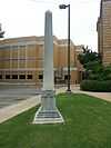 |
(#96000455) |
Southwestern corner of the courthouse lawn, east of the junction of Robinson Ave. and Center St. 35°05′19″N 92°26′35″W / 35.088611°N 92.443056°W |
Conway | part of the Civil War Commemorative Sculpture MPS |
| 10 | Earl and Oza Crownover-Brown House | Upload image | (#06000088) |
133 S. Broadway 35°21′25″N 92°24′48″W / 35.356944°N 92.413333°W |
Damascus | |
| 11 | O.L. Dunaway House | 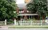 |
(#96000797) |
920 Center St. 35°05′26″N 92°26′42″W / 35.090556°N 92.445°W |
Conway | |
| 12 | Richard and Mettie Ealy House | Upload image | (#05001069) |
280 Solomon Grove Rd. 35°18′45″N 92°26′51″W / 35.3125°N 92.4475°W |
Twin Groves | part of the Mixed Masonry Buildings of Silas Owens, Sr. MPS |
| 13 | Farmers State Bank | 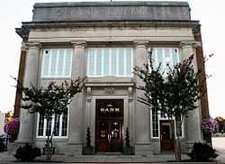 |
(#82000812) |
1001 Front St. 35°05′31″N 92°26′28″W / 35.091944°N 92.441111°W |
Conway | part of the Charles L. Thompson Design Collection TR |
| 14 | Faulkner County Courthouse | 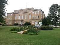 |
(#95001381) |
801 Locust St. 35°05′20″N 92°26′34″W / 35.088889°N 92.442778°W |
Conway | |
| 15 | Faulkner County Jail | 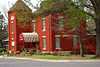 |
(#78000585) |
Courthouse Sq. 35°05′21″N 92°26′37″W / 35.089167°N 92.443611°W |
Conway | |
| 16 | First United Methodist Church | 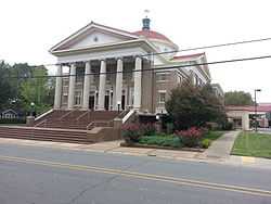 |
(#92001623) |
Northwestern corner of the junction of Prince and Clifton Sts. 35°05′32″N 92°26′44″W / 35.092222°N 92.445556°W |
Conway | |
| 17 | Frauenthal & Schwarz Building | 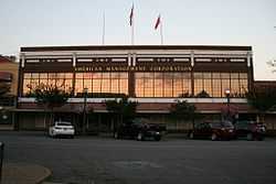 |
(#92000956) |
824 Front St. 35°05′29″N 92°26′27″W / 35.091389°N 92.440833°W |
Conway | |
| 18 | Frauenthal House | 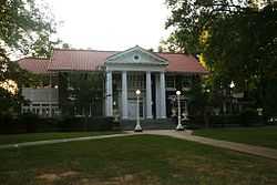 |
(#82000814) |
631 Western 35°05′14″N 92°27′28″W / 35.087222°N 92.457778°W |
Conway | part of the Charles L. Thompson Design Collection TR |
| 19 | Galloway Hall | Upload image | (#82000953) |
Hendrix College campus 35°06′06″N 92°26′28″W / 35.101667°N 92.441111°W |
Conway | part of the Charles L. Thompson Design Collection TR |
| 20 | Dennis and Christine Garrison House | Upload image | (#05001070) |
105 Garrison Rd. 35°14′25″N 92°27′03″W / 35.240256°N 92.450881°W |
Greenbrier | part of the Mixed Masonry Buildings of Silas Owens, Sr. MPS |
| 21 | Greeson-Cone House | 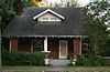 |
(#95001094) |
928 Center St. 35°05′28″N 92°26′41″W / 35.091111°N 92.444722°W |
Conway | |
| 22 | Guy High School Gymnasium | Upload image | (#92001196) |
Highway 25 35°19′24″N 92°19′24″W / 35.323333°N 92.323333°W |
Guy | part of the Public Schools in the Ozarks MPS |
| 23 | Guy Home Economics Building | Upload image | (#92001197) |
Highway 25 35°19′25″N 92°19′22″W / 35.323611°N 92.322778°W |
Guy | part of the Public Schools in the Ozarks MPS |
| 24 | Charlie Hall House | Upload image | (#05000492) |
221 Old U.S. Highway 65 35°20′25″N 92°23′59″W / 35.340278°N 92.399722°W |
Twin Groves | part of the Mixed Masonry Buildings of Silas Owens, Sr. MPS |
| 25 | Hall–Hogan Grocery Store | 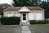 |
(#13000785) |
1364 Mitchell 35°05′53″N 92°26′58″W / 35.098076°N 92.449493°W |
Conway | |
| 26 | Frank U. Halter House | 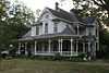 |
(#80000776) |
1355 College Ave. 35°05′03″N 92°26′26″W / 35.084167°N 92.440556°W |
Conway | |
| 27 | Hardy Cemetery | Upload image | (#09000798) |
722 Highway 225, E. 35°15′24″N 92°15′15″W / 35.256528°N 92.254247°W |
Centerville | |
| 28 | Harton House | 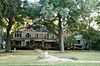 |
(#79000438) |
1821 Robinson Ave. 35°05′16″N 92°26′56″W / 35.087778°N 92.448889°W |
Conway | |
| 29 | D.O. Harton House | 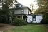 |
(#96000796) |
607 Davis St. 35°05′11″N 92°26′53″W / 35.086389°N 92.448056°W |
Conway | |
| 30 | Hendrix College Addition Neighborhood Historic District | Upload image | (#07000973) |
Roughly bounded by Washington Ave., Fleming St., Harkrider St., and Winfield St. 35°06′16″N 92°26′34″W / 35.104317°N 92.442667°W |
Conway | |
| 31 | Michael M. Hiegel House |  |
(#98000912) |
504 2nd St. 35°05′17″N 92°25′57″W / 35.088056°N 92.4325°W |
Conway | |
| 32 | E.E. Hooten House | Upload image | (#05000039) |
400 Highway 25, N. 35°19′13″N 92°20′17″W / 35.320278°N 92.338056°W |
Guy | part of the Mixed Masonry Buildings of Silas Owens, Sr. MPS |
| 33 | Farris and Evelyn Langley House | Upload image | (#05000493) |
12 Langley Ln. 35°17′17″N 92°23′53″W / 35.288056°N 92.398056°W |
Republican | part of the Mixed Masonry Buildings of Silas Owens, Sr. MPS |
| 34 | Lasley's College Apartments | 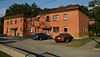 |
(#11000300) |
1916 & 1922 Bruce St. 35°04′58″N 92°27′03″W / 35.082778°N 92.450833°W |
Conway | |
| 35 | Lee Service Station | Upload image | (#05000044) |
28 S. Broadway 35°21′56″N 92°24′38″W / 35.365556°N 92.410556°W |
Damascus | part of the Mixed Masonry Buildings of Silas Owens, Sr. MPS |
| 36 | Liberty School Cafeteria | Upload image | (#92001195) |
Highway 36, north of its junction with U.S. Highway 64 35°04′53″N 92°18′21″W / 35.081389°N 92.305833°W |
Hamlet | part of the Public Schools in the Ozarks MPS |
| 37 | J.E. Little House | 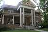 |
(#98001631) |
427 Western Ave. 35°05′03″N 92°27′22″W / 35.084167°N 92.456111°W |
Conway | |
| 38 | Martin Hall | Upload image | (#82000815) |
Hendrix College campus 35°05′58″N 92°26′28″W / 35.099444°N 92.441111°W |
Conway | part of the Charles L. Thompson Design Collection TR |
| 39 | Merritt House | Upload image | (#05001071) |
139 N. Broadview 35°15′15″N 92°23′16″W / 35.254167°N 92.387778°W |
Greenbrier | part of the Mixed Masonry Buildings of Silas Owens, Sr. MPS |
| 40 | S.D. Merritt House | Upload image | (#05000038) |
45 Highway 25, N. 35°16′24″N 92°22′59″W / 35.273333°N 92.383056°W |
Greenbrier | part of the Mixed Masonry Buildings of Silas Owens, Sr. MPS |
| 41 | Military Road-Cadron Segment | Upload image | (#03001490) |
Address Restricted |
Conway | Segment of the Trail of Tears; part of the Cherokee Trail of Tears MPS[6] |
| 42 | Mt. Zion Missionary Baptist Church | Upload image | (#09000003) |
249 Highway 107 35°11′46″N 92°12′12″W / 35.196111°N 92.203267°W |
Enola | part of the Mixed Masonry Buildings of Silas Owens, Sr. MPS |
| 43 | Oak Grove Cemetery Historic Section | Upload image | (#09000341) |
E. Bruce St. approximately 0.3 miles (0.48 km) east of Harkrider St. 35°04′51″N 92°25′50″W / 35.080728°N 92.430622°W |
Conway | |
| 44 | Silas Owens Sr. House | Upload image | (#05000045) |
157 Solomon Grove Rd. 35°19′16″N 92°26′04″W / 35.321111°N 92.434444°W |
Twin Groves | part of the Mixed Masonry Buildings of Silas Owens, Sr. MPS |
| 45 | Patton House | Upload image | (#93001026) |
Highway 25 35°12′04″N 92°27′09″W / 35.201111°N 92.4525°W |
Wooster | |
| 46 | President's House | Upload image | (#82000816) |
Hendrix College campus 35°05′53″N 92°26′32″W / 35.098056°N 92.442222°W |
Conway | part of the Charles L. Thompson Design Collection TR |
| 47 | Quattlebaum-Pelletier House | Upload image | (#05000494) |
43 Ozark 35°18′10″N 92°23′56″W / 35.302778°N 92.398889°W |
Twin Groves | part of the Mixed Masonry Buildings of Silas Owens, Sr. MPS |
| 48 | Frank E. Robins House | 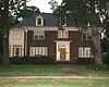 |
(#94000497) |
567 Locust St. 35°05′09″N 92°26′29″W / 35.085833°N 92.441389°W |
Conway | |
| 49 | Reuben W. Robins House | 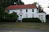 |
(#05001072) |
508 Locust St. 35°05′14″N 92°26′26″W / 35.087222°N 92.440556°W |
Conway | |
| 50 | Robinson Historic District | Upload image | (#00001645) |
Roughly bounded by Cross, Prince, Faulkner, and Watkins Sts., and Robinson Ave. 35°05′23″N 92°26′54″W / 35.089722°N 92.448333°W |
Conway | |
| 51 | James and Jewell Salter House | Upload image | (#05000495) |
159 S. Broadview 35°12′50″N 92°23′19″W / 35.213889°N 92.388611°W |
Greenbrier | part of the Mixed Masonry Buildings of Silas Owens, Sr. MPS |
| 52 | Sellers House | Upload image | (#05000042) |
89 Acklin Gap Rd. 35°08′05″N 92°23′23″W / 35.134722°N 92.389722°W |
Conway | part of the Mixed Masonry Buildings of Silas Owens, Sr. MPS |
| 53 | S.G. Smith House | 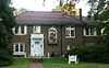 |
(#82000853) |
1837 Caldwell St. 35°05′24″N 92°27′01″W / 35.09°N 92.450278°W |
Conway | part of the Charles L. Thompson Design Collection TR |
| 54 | Solomon Grove Smith-Hughes Building | Upload image | (#94001461) |
South of County Road 29 35°19′14″N 92°26′00″W / 35.320556°N 92.433333°W |
Twin Groves | part of the Public Schools in the Ozarks MPS |
| 55 | Spears House | Upload image | (#05000043) |
1235 U.S. Highway 65, N. 35°17′11″N 92°23′32″W / 35.286389°N 92.392222°W |
Greenbrier | part of the Mixed Masonry Buildings of Silas Owens, Sr. MPS |
| 56 | Springfield Bridge | Upload image | (#88000660) |
County Road 222 at Cadron Creek 35°15′09″N 92°30′45″W / 35.2525°N 92.5125°W |
Springfield | |
| 57 | Titan II ICBM Launch Complex 374-5 Site | Upload image | (#98001433) |
East of U.S. Highway 65, 0.4 miles (0.64 km) north of its junction with E. Cadron Ridge Rd. 35°09′52″N 92°23′46″W / 35.164444°N 92.396111°W |
Springhill | part of the Cold War Resources Associated with the 308th Strategic Missile Wing in Arkansas MPS |
| 58 | Tyler-Southerland House | Upload image | (#05001168) |
36 Southerland 35°04′17″N 92°24′20″W / 35.071389°N 92.405556°W |
Conway | part of the Mixed Masonry Buildings of Silas Owens, Sr. MPS |
| 59 | University of Central Arkansas Historic District | 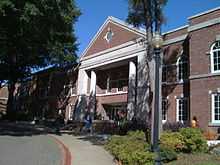 |
(#13000064) |
201 Donaghey Ave. 35°04′49″N 92°27′18″W / 35.080321°N 92.45489°W |
Conway | |
| 60 | Earl and Mildred Ward House | 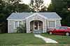 |
(#05001169) |
1157 Mitchell St. 35°05′40″N 92°26′59″W / 35.094444°N 92.449722°W |
Conway | part of the Mixed Masonry Buildings of Silas Owens, Sr. MPS |
| 61 | Washburn House | Upload image | (#06001279) |
40 Battles Loop 35°19′03″N 92°21′31″W / 35.3175°N 92.358611°W |
Guy | part of the Mixed Masonry Buildings of Silas Owens, Sr. MPS |
| 62 | Young Memorial | Upload image | (#96000758) |
1601 Harkrider Dr., north of Reynolds Science Hall 35°06′01″N 92°26′30″W / 35.100278°N 92.441667°W |
Conway |
Former listings
| [3] | Name on the Register | Image | Date listed | Date removed | Location | City or town | Summary |
|---|---|---|---|---|---|---|---|
| 1 | First Baptist Church | Upload image | (#82000813) | Davis and Robinson Street |
Conway | ||
| 2 | Main Hall, Central College | Upload image | (#75000385) | 1509 College Ave., Central Baptist College |
Conway | ||
| 3 | Joe and Nina Webb House | Upload image | (#05001171) | 2945 Prince |
Conway | part of the Mixed Masonry Buildings of Silas Owens, Sr. MPS |
See also
| Wikimedia Commons has media related to National Register of Historic Places in Faulkner County, Arkansas. |
- List of National Historic Landmarks in Arkansas
- National Register of Historic Places listings in Arkansas
References
- ↑ The latitude and longitude information provided in this table was derived originally from the National Register Information System, which has been found to be fairly accurate for about 99% of listings. For about 1% of NRIS original coordinates, experience has shown that one or both coordinates are typos or otherwise extremely far off; some corrections may have been made. A more subtle problem causes many locations to be off by up to 150 yards, depending on location in the country: most NRIS coordinates were derived from tracing out latitude and longitudes off of USGS topographical quadrant maps created under the North American Datum of 1927, which differs from the current, highly accurate WGS84 GPS system used by most on-line maps. Chicago is about right, but NRIS longitudes in Washington are higher by about 4.5 seconds, and are lower by about 2.0 seconds in Maine. Latitudes differ by about 1.0 second in Florida. Some locations in this table may have been corrected to current GPS standards.
- ↑ "National Register of Historic Places: Weekly List Actions". National Park Service, United States Department of the Interior. Retrieved on May 1, 2015.
- ↑ 3.0 3.1 Numbers represent an ordering by significant words. Various colorings, defined here, differentiate National Historic Landmarks and historic districts from other NRHP buildings, structures, sites or objects.
- ↑ "National Register Information System". National Register of Historic Places. National Park Service. 2009-03-13.
- ↑ The eight-digit number below each date is the number assigned to each location in the National Register Information System database, which can be viewed by clicking the number.
- ↑ 6.0 6.1 "Trail Of Tears National Historic Trail: National Register Research". National Park Service. Retrieved January 22, 2013.
| ||||||||||||||||||||||||||
| |||||||||||||||||||||||||