National Register of Historic Places listings in Fall River County, South Dakota

Location of Fall River County in South Dakota
This is a list of the National Register of Historic Places listings in Fall River County, South Dakota.
This is intended to be a complete list of the properties and districts on the National Register of Historic Places in Fall River County, South Dakota, United States. The locations of National Register properties and districts for which the latitude and longitude coordinates are included below, may be seen in a Google map.[1]
There are 72 properties and districts listed on the National Register in the county. Another property was once listed but has been removed.
- This National Park Service list is complete through NPS recent listings posted May 1, 2015.[2]
Current listings
| [3] | Name on the Register[4] | Image | Date listed[5] | Location | City or town | Description |
|---|---|---|---|---|---|---|
| 1 | Allen Bank Building and Cascade Springs Bath House-Sanitarium | Upload image | (#84003285) |
Address Restricted |
Hot Springs | |
| 2 | Archeological Site No. 39FA86 | Upload image | (#93000804) |
Address Restricted |
Edgemont | |
| 3 | Archeological Site No. 39FA88 | Upload image | (#93001040) |
Address Restricted |
Edgemont | |
| 4 | Archeological Site No. 39FA89 | Upload image | (#93000806) |
Address Restricted |
Edgemont | |
| 5 | Archeological Site No. 39FA90 | Upload image | (#93001041) |
Address Restricted |
Hot Springs | |
| 6 | Archeological Site No. 39FA99 | Upload image | (#93001042) |
Address Restricted |
Edgemont | |
| 7 | Archeological Site No. 39FA243 | Upload image | (#93001043) |
Address Restricted |
Edgemont | |
| 8 | Archeological Site No. 39FA244 | Upload image | (#93001044) |
Address Restricted |
Edgemont | |
| 9 | Archeological Site No. 39FA316 | Upload image | (#93001045) |
Address Restricted |
Edgemont | |
| 10 | Archeological Site No. 39FA321 | Upload image | (#93001046) |
Address Restricted |
Edgemont | |
| 11 | Archeological Site No. 39FA395 | Upload image | (#93001047) |
Address Restricted |
Edgemont | |
| 12 | Archeological Site No. 39FA446 | Upload image | (#93001048) |
Address Restricted |
Edgemont | |
| 13 | Archeological Site No. 39FA447 | Upload image | (#93001049) |
Address Restricted |
Edgemont | |
| 14 | Archeological Site No. 39FA448 | Upload image | (#93001050) |
Address Restricted |
Edgemont | |
| 15 | Archeological Site No. 39FA542 | Upload image | (#93001051) |
Address Restricted |
Edgemont | |
| 16 | Archeological Site No. 39FA678 | Upload image | (#93000801) |
Address Restricted |
Edgemont | |
| 17 | Archeological Site No. 39FA679 | Upload image | (#93001052) |
Address Restricted |
Edgemont | |
| 18 | Archeological Site No. 39FA680 | Upload image | (#93001053) |
Address Restricted |
Edgemont | |
| 19 | Archeological Site No. 39FA682 | Upload image | (#93001054) |
Address Restricted |
Edgemont | |
| 20 | Archeological Site No. 39FA683 | Upload image | (#93001055) |
Address Restricted |
Edgemont | |
| 21 | Archeological Site No. 39FA686 | Upload image | (#93001056) |
Address Restricted |
Edgemont | |
| 22 | Archeological Site No. 39FA688 | Upload image | (#93001057) |
Address Restricted |
Edgemont | |
| 23 | Archeological Site No. 39FA690 | Upload image | (#93001058) |
Address Restricted |
Edgemont | |
| 24 | Archeological Site No. 39FA691 | Upload image | (#93001059) |
Address Restricted |
Edgemont | |
| 25 | Archeological Site No. 39FA767 | Upload image | (#93001060) |
Address Restricted |
Edgemont | |
| 26 | Archeological Site No. 39FA788 | Upload image | (#93001061) |
Address Restricted |
Edgemont | |
| 27 | Archeological Site No. 39FA806 | Upload image | (#93000790) |
Address Restricted |
Hot Springs | |
| 28 | Archeological Site No. 39FA819 | Upload image | (#93001062) |
Address Restricted |
Edgemont | |
| 29 | Archeological Site No. 39FA1010 | Upload image | (#93001063) |
Address Restricted |
Hot Springs | |
| 30 | Archeological Site No. 39FA1013 | Upload image | (#93001064) |
Address Restricted |
Hot Springs | |
| 31 | Archeological Site No. 39FA1046 | Upload image | (#93001065) |
Address Restricted |
Edgemont | |
| 32 | Archeological Site No. 39FA1049 | Upload image | (#93000791) |
Address Restricted |
Hot Springs | |
| 33 | Archeological Site No. 39FA1093 | Upload image | (#93001066) |
Address Restricted |
Hot Springs | |
| 34 | Archeological Site No. 39FA1152 | Upload image | (#93001067) |
Address Restricted |
Hot Springs | |
| 35 | Archeological Site No. 39FA1154 | Upload image | (#93001068) |
Address Restricted |
Hot Springs | |
| 36 | Archeological Site No. 39FA1155 | Upload image | (#93001069) |
Address Restricted |
Hot Springs | |
| 37 | Archeological Site No. 39FA1190 | Upload image | (#93001070) |
Address Restricted |
Edgemont | |
| 38 | Archeological Site No. 39FA1201 | Upload image | (#93000792) |
Address Restricted |
Edgemont | |
| 39 | Archeological Site No. 39FA1204 | Upload image | (#93001071) |
Address Restricted |
Hot Springs | |
| 40 | Archeological Site 39FA1336 | Upload image | (#05000690) |
Address Restricted |
Edgemont | |
| 41 | Archeological Site 39FA1337 | Upload image | (#05000689) |
Address Restricted |
Edgemont | |
| 42 | Archeological Site 39FA1638 | Upload image | (#05000691) |
Address Restricted |
Edgemont | |
| 43 | Bartlett-Myers Building | Upload image | (#06000457) |
506½ 2nd Ave. 43°18′01″N 103°49′32″W / 43.300278°N 103.825556°W |
Edgemont | |
| 44 | Battle Mountain Sanitarium, National Home For Disabled Volunteer Soldiers | 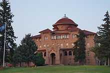 |
(#11000561) |
500 North 5th St. 43°26′13″N 103°28′35″W / 43.436944°N 103.476389°W |
Hot Springs | |
| 45 | Chilson Bridge | Upload image | (#93001287) |
Local road over BNSF railroad tracks 43°19′47″N 103°44′02″W / 43.329722°N 103.733889°W |
Edgemont | |
| 46 | Flint Hill Aboriginal Quartzite Quarry | Upload image | (#78002552) |
Address Restricted |
Edgemont | |
| 47 | Hot Springs High School | 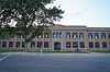 |
(#80003721) |
146 N. 16th St. 43°25′50″N 103°28′51″W / 43.430556°N 103.480833°W |
Hot Springs | |
| 48 | Hot Springs Historic District | |
(#74001890) |
Roughly both sides of River St. from Summit Rd. south to Baltimore St., including part of Minnekahta Ave. 43°26′02″N 103°28′38″W / 43.433889°N 103.477222°W |
Hot Springs | |
| 49 | Governor Leslie Jensen House | 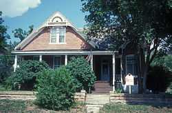 |
(#87001731) |
309 S. 5th St. 43°25′46″N 103°28′12″W / 43.429444°N 103.47°W |
Hot Springs | |
| 50 | Log Cabin Tourist Camp | Upload image | (#03001525) |
Highway 1 43°26′38″N 103°28′35″W / 43.443889°N 103.476389°W |
Hot Springs | |
| 51 | Lord's Ranch Rockshelter | Upload image | (#05000688) |
Address Restricted |
Edgemont | |
| 52 | Petty House | Upload image | (#99000202) |
201 N. 3rd St. 43°26′04″N 103°28′09″W / 43.434444°N 103.469167°W |
Hot Springs | |
| 53 | St. Martin's Catholic Church and Grotto | Upload image | (#03000764) |
Lot Six Block 5 43°10′55″N 103°13′51″W / 43.181944°N 103.230833°W |
Oelrichs | |
| 54 | Site No. 39 FA 7 | Upload image | (#82004771) |
Address Restricted |
City restricted | |
| 55 | Site No. 39 FA 58 | Upload image | (#82004765) |
Address Restricted |
City restricted | |
| 56 | Site No. 39 FA 75 | Upload image | (#82004760) |
Address Restricted |
City restricted | |
| 57 | Site No. 39 FA 79 | Upload image | (#82004772) |
Address Restricted |
City restricted | |
| 58 | Site No. 39 FA 91 | Upload image | (#82004773) |
Address Restricted |
City restricted | |
| 59 | Site No. 39 FA 94 | Upload image | (#82004774) |
Address Restricted |
City restricted | |
| 60 | Site No. 39 FA 277 | Upload image | (#82004761) |
Address Restricted |
City restricted | |
| 61 | Site No. 39 FA 389 | Upload image | (#82004762) |
Address Restricted |
City restricted | |
| 62 | Site No. 39 FA 554 | Upload image | (#82004764) |
Address Restricted |
City restricted | |
| 63 | Site No. 39 FA 676 | Upload image | (#82004766) |
Address Restricted |
City restricted | |
| 64 | Site No. 39 FA 677 | Upload image | (#82004767) |
Address Restricted |
City restricted | |
| 65 | Site No. 39 FA 681 | Upload image | (#82004769) |
Address Restricted |
City restricted | |
| 66 | Site No. 39 FA 684 | Upload image | (#82004768) |
Address Restricted |
City restricted | |
| 67 | Site No. 39 FA 685 | Upload image | (#82004906) |
Address Restricted |
City restricted | |
| 68 | Site No. 39 FA 687 | Upload image | (#82004770) |
Address Restricted |
City restricted | |
| 69 | Site 39FA1303 | Upload image | (#05000587) |
Address Restricted |
Edgemont | |
| 70 | Site 39FA1639 | Upload image | (#05000586) |
Address Restricted |
Edgemont | |
| 71 | State Soldiers Home Barn | 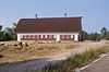 |
(#09000446) |
2500 Minnekahta Ave. 43°26′11″N 103°29′18″W / 43.436492°N 103.48835°W |
Hot Springs | |
| 72 | Phillip Wesch House | Upload image | (#84003287) |
2229 Minnekahta Ave. 43°26′15″N 103°29′24″W / 43.4375°N 103.49°W |
Hot Springs |
Former listing
| [3] | Name on the Register | Image | Date listed | Date removed | Location | City or town | Summary |
|---|---|---|---|---|---|---|---|
| 1 | Edgemont Block | Upload image | (#96001232) | 610 2nd Avenue |
Edgemont |
See also
| Wikimedia Commons has media related to National Register of Historic Places in Fall River County, South Dakota. |
- List of National Historic Landmarks in South Dakota
- National Register of Historic Places listings in South Dakota
References
- ↑ The latitude and longitude information provided in this table was derived originally from the National Register Information System, which has been found to be fairly accurate for about 99% of listings. For about 1% of NRIS original coordinates, experience has shown that one or both coordinates are typos or otherwise extremely far off; some corrections may have been made. A more subtle problem causes many locations to be off by up to 150 yards, depending on location in the country: most NRIS coordinates were derived from tracing out latitude and longitudes off of USGS topographical quadrant maps created under the North American Datum of 1927, which differs from the current, highly accurate WGS84 GPS system used by most on-line maps. Chicago is about right, but NRIS longitudes in Washington are higher by about 4.5 seconds, and are lower by about 2.0 seconds in Maine. Latitudes differ by about 1.0 second in Florida. Some locations in this table may have been corrected to current GPS standards.
- ↑ "National Register of Historic Places: Weekly List Actions". National Park Service, United States Department of the Interior. Retrieved on May 1, 2015.
- ↑ 3.0 3.1 Numbers represent an ordering by significant words. Various colorings, defined here, differentiate National Historic Landmarks and historic districts from other NRHP buildings, structures, sites or objects.
- ↑ "National Register Information System". National Register of Historic Places. National Park Service. 2008-04-24.
- ↑ The eight-digit number below each date is the number assigned to each location in the National Register Information System database, which can be viewed by clicking the number.
| ||||||||||||||||||||||||||
| |||||||||||||||||||||||||||||