National Register of Historic Places listings in Essex County, Vermont
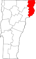
Location of Essex County in Vermont
This is a list of the National Register of Historic Places listings in Essex County, Vermont.
This is intended to be a complete list of the properties and districts on the National Register of Historic Places in Essex County, Vermont, United States. Latitude and longitude coordinates are provided for many National Register properties and districts; these locations may be seen together in a Google map.[1]
There are 11 properties and districts listed on the National Register in the county.
- This National Park Service list is complete through NPS recent listings posted May 1, 2015.[2]
Current listings
| [3] |
Name on the Register[4] |
Image |
Date listed[5] |
Location |
City or town |
Description |
|---|
| 1 |
Bloomfield-Nulhegan River Route 102 Bridge |
Upload image |
01991-11-14-0000November 14, 1991
(#91001605) |
VT 102 over the Nulhegan River
44°45′10″N 71°38′48″W / 44.752778°N 71.646667°W / 44.752778; -71.646667 (Bloomfield-Nulhegan River Route 102 Bridge) |
Bloomfield |
|
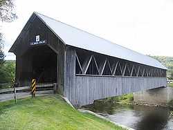
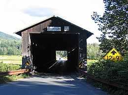
| 2 |
Columbia Covered Bridge |
|
01976-12-12-0000December 12, 1976
(#76000123) |
Across the Connecticut River between U.S. Route 3 and VT 102
44°51′12″N 71°33′05″W / 44.853333°N 71.551389°W / 44.853333; -71.551389 (Columbia Covered Bridge) |
Lemington |
Extends into Coos County, New Hampshire
|
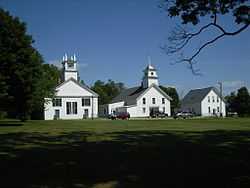
| 3 |
Guildhall Village Historic District |
|
01980-09-27-0000September 27, 1980
(#80000331) |
VT 102
44°33′56″N 71°33′46″W / 44.565556°N 71.562778°W / 44.565556; -71.562778 (Guildhall Village Historic District) |
Guildhall |
|
| 4 |
Judge David Hibbard Homestead |
Upload image |
01995-03-31-0000March 31, 1995
(#95000294) |
Woodland Rd.
44°27′06″N 71°53′30″W / 44.451667°N 71.891667°W / 44.451667; -71.891667 (Judge David Hibbard Homestead) |
Concord |
|
| 5 |
Island Pond Historic District |
|
01979-01-31-0000January 31, 1979
(#79000275) |
Junction of VT 105 and VT 114
44°48′42″N 71°53′01″W / 44.811667°N 71.883611°W / 44.811667; -71.883611 (Island Pond Historic District) |
Island Pond |
|
| 6 |
Jacobs Stand |
Upload image |
01980-06-03-0000June 3, 1980
(#80000332) |
W. Park St.
44°59′45″N 71°32′23″W / 44.995833°N 71.539722°W / 44.995833; -71.539722 (Jacobs Stand) |
Canaan |
|
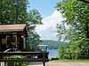
| 7 |
Maidstone State Park |
|
02001-11-29-0000November 29, 2001
(#01001285) |
4858 and 4876 Maidstone Rd.
44°38′11″N 71°39′07″W / 44.636389°N 71.651944°W / 44.636389; -71.651944 (Maidstone State Park) |
Maidstone |
|
| 8 |
Mount Orne Covered Bridge |
|
01976-12-12-0000December 12, 1976
(#76000124) |
Southwest of Lancaster off NH 135
44°27′38″N 71°39′12″W / 44.460556°N 71.653333°W / 44.460556; -71.653333 (Mount Orne Covered Bridge) |
Lunenburg |
Extends into Coos County, New Hampshire
|
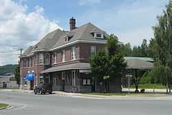
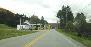
| 9 |
U.S. Inspection Station-Canaan, Vermont |
|
02014-09-10-0000September 10, 2014
(#14000601) |
387 VT 141
45°00′43″N 71°33′36″W / 45.0119°N 71.56°W / 45.0119; -71.56 (U.S. Inspection Station-Canaan, Vermont) |
Canaan |
|
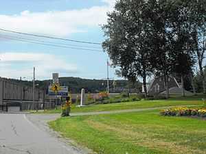
| 10 |
U.S. Inspection Station-Beecher Falls, Vermont |
|
02014-09-10-0000September 10, 2014
(#14000602) |
1429 VT 253
45°00′46″N 71°30′22″W / 45.0128°N 71.5061°W / 45.0128; -71.5061 (U.S. Inspection Station-Beecher Falls, Vermont) |
Canaan |
|
| 11 |
U.S. Inspection Station-Norton, Vermont |
Upload image |
02014-09-10-0000September 10, 2014
(#14000603) |
115 VT 147N
45°00′37″N 71°47′39″W / 45.0104°N 71.7941°W / 45.0104; -71.7941 (U.S. Inspection Station-Norton, Vermont) |
Norton |
|
See also
References
- ↑ The latitude and longitude information provided in this table was derived originally from the National Register Information System, which has been found to be fairly accurate for about 99% of listings. For about 1% of NRIS original coordinates, experience has shown that one or both coordinates are typos or otherwise extremely far off; some corrections may have been made. A more subtle problem causes many locations to be off by up to 150 yards, depending on location in the country: most NRIS coordinates were derived from tracing out latitude and longitudes off of USGS topographical quadrant maps created under the North American Datum of 1927, which differs from the current, highly accurate WGS84 GPS system used by most on-line maps. Chicago is about right, but NRIS longitudes in Washington are higher by about 4.5 seconds, and are lower by about 2.0 seconds in Maine. Latitudes differ by about 1.0 second in Florida. Some locations in this table may have been corrected to current GPS standards.
- ↑ "National Register of Historic Places: Weekly List Actions". National Park Service, United States Department of the Interior. Retrieved on May 1, 2015.
- ↑ Numbers represent an ordering by significant words. Various colorings, defined here, differentiate National Historic Landmarks and historic districts from other NRHP buildings, structures, sites or objects.
- ↑ "National Register Information System". National Register of Historic Places. National Park Service. 2008-04-24.
- ↑ The eight-digit number below each date is the number assigned to each location in the National Register Information System database, which can be viewed by clicking the number.
|
|---|
| | Topics | |
|---|
| | Lists by states | |
|---|
| | Lists by insular areas | |
|---|
| | Lists by associated states | |
|---|
| | Other areas | |
|---|
|
-
 Category Category
-
 Portal Portal
-
 WikiProject WikiProject
|
|