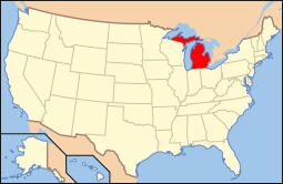
National Register of Historic Places listings in Emmet County, Michigan
The following is a list of Registered Historic Places in Emmet County, Michigan.
- This National Park Service list is complete through NPS recent listings posted May 1, 2015.[1]
| [2] | Name on the Register[3] | Image | Date listed[4] | Location | City or town | Description |
|---|---|---|---|---|---|---|
| 1 | J. B. Allen House | Upload image | (#86001973) |
822 Grove St. 45°22′14″N 84°56′49″W / 45.370556°N 84.946944°W |
Petoskey | |
| 2 | Isaac Bartram House | Upload image | (#86001975) |
508 Wachtel Ave. 45°22′23″N 84°57′46″W / 45.373056°N 84.962778°W |
Petoskey | |
| 3 | Bay View | 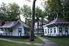 |
(#72000613) |
Northeast of Petoskey on US 31 45°22′57″N 84°55′56″W / 45.3825°N 84.932222°W |
Petoskey | Established in 1876 as a Methodist camp meeting, this romantically-planned campground was converted to an independent chautauqua in 1885, a role it served until 1915. These two uniquely American community forms are exemplified in this extensive and well-preserved complex. |
| 4 | Chief Andrew J. Blackbird House |  |
(#72000611) |
368 E. Main St. 45°25′49″N 84°59′05″W / 45.430278°N 84.984722°W |
Harbor Springs | |
| 5 | W. S. Carmichael House | Upload image | (#86001977) |
301 Jackson St. 45°22′16″N 84°57′50″W / 45.371111°N 84.963889°W |
Petoskey | |
| 6 | Chesapeake & Ohio Railway Station | Upload image | (#70000270) |
Pioneer Park, W. Lake St. 45°22′31″N 84°57′33″W / 45.375278°N 84.959167°W |
Petoskey | |
| 7 | I. N. Debenham House | Upload image | (#86001979) |
1101 Emmet St. 45°22′00″N 84°57′31″W / 45.366667°N 84.958611°W |
Petoskey | |
| 8 | East Mitchell Street Historic District | 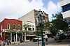 |
(#86001983) |
Roughly bounded by Rose, Kalamazoo, State, Howard, Michigan, and Division 45°22′24″N 84°56′59″W / 45.373333°N 84.949722°W |
Petoskey | |
| 9 | Gerhard Fochtman House | Upload image | (#86001998) |
1004 Waukazoo Ave. 45°22′07″N 84°57′12″W / 45.368611°N 84.953333°W |
Petoskey | |
| 10 | Fort Michilimackinac |  |
(#66000395) |
Near Mackinac Bridge at the southern end of the Mackinac Bridge 45°47′12″N 84°43′58″W / 45.786667°N 84.732778°W |
Mackinaw City | |
| 11 | Fourth Ward Polling Place | Upload image | (#86002001) |
209 Washington St. 45°22′06″N 84°57′29″W / 45.368333°N 84.958056°W |
Petoskey | |
| 12 | Meyer Fryman House | Upload image | (#86002002) |
211 Michigan St. 45°22′23″N 84°57′29″W / 45.373056°N 84.958056°W |
Petoskey | |
| 13 | Grace Methodist Episcopal Church | Upload image | (#86002012) |
625 Connable St. 45°22′15″N 84°58′08″W / 45.370833°N 84.968889°W |
Petoskey | |
| 14 | Grand Rapids and Indiana Railroad Harbor Springs Depot | 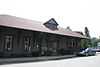 |
(#00001487) |
111 W. Bay St. 45°25′43″N 84°59′22″W / 45.428611°N 84.989444°W |
Harbor Springs | |
| 15 | Grays Reef Light Station | 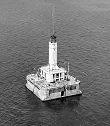 |
(#05001210) |
In northeastern Lake Michigan, 3.8 mi (6.1 km) west of Waugashance Island 45°46′00″N 85°09′12″W / 45.766667°N 85.153333°W |
Bliss Township | |
| 16 | Ernest Hemingway Cottage |  |
(#68000026) |
Between the northern shore of Walloon Lake and Lake Grove Rd. 45°16′48″N 84°59′57″W / 45.28°N 84.999167°W |
Walloon Lake | Boyhood summer home of author Ernest Hemingway. His father built the house in 1900 when Hemingway was a year old and it was here the future writer learned to hunt and fish and appreciate the outdoor life he came to celebrate in his writings. |
| 17 | Bert and John Hobbins House | Upload image | (#86002013) |
1024 Emmet St. 45°22′04″N 84°57′33″W / 45.367778°N 84.959167°W |
Petoskey | |
| 18 | Hosman and Wheeler Meat Market | Upload image | (#86002015) |
621 Ingalls Ave. 45°22′14″N 84°57′56″W / 45.370556°N 84.965556°W |
Petoskey | |
| 19 | John Kabler House | Upload image | (#86002017) |
415 Jackson St. 45°22′17″N 84°58′01″W / 45.371389°N 84.966944°W |
Petoskey | |
| 20 | Frank Lesher House | Upload image | (#86002018) |
122 Sheridan St. 45°21′54″N 84°57′36″W / 45.365°N 84.96°W |
Petoskey | |
| 21 | A. Malin House | Upload image | (#86002020) |
54 Bridge St. 45°22′07″N 84°57′46″W / 45.368611°N 84.962778°W |
Petoskey | |
| 22 | George and Eugene Markle House | Upload image | (#86002023) |
701 Kalamazoo St. 45°22′14″N 84°56′43″W / 45.370556°N 84.945278°W |
Petoskey | |
| 23 | George McManus House | Upload image | (#86002026) |
121 State St. 45°22′19″N 84°57′33″W / 45.371944°N 84.959167°W |
Petoskey | |
| 24 | Elias Meyers House | Upload image | (#86002030) |
912 Baxter St. 45°22′08″N 84°57′39″W / 45.368889°N 84.960833°W |
Petoskey | |
| 25 | Jacob Miller House | Upload image | (#86002031) |
307 Jackson St. 45°22′16″N 84°57′51″W / 45.371111°N 84.964167°W |
Petoskey | |
| 26 | Mineral Well Park | 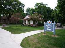 |
(#86002036) |
W. Lake St. 45°22′31″N 84°57′37″W / 45.375278°N 84.960278°W |
Petoskey | |
| 27 | John Nyman House | Upload image | (#86002039) |
915 Emmet St. 45°22′07″N 84°57′31″W / 45.368611°N 84.958611°W |
Petoskey | |
| 28 | G. W. Olin House | Upload image | (#86002042) |
610 Kalamazoo St. 45°22′17″N 84°56′44″W / 45.371389°N 84.945556°W |
Petoskey | |
| 29 | Sarah Pennington House | Upload image | (#86002045) |
719 Maple St. 45°22′09″N 84°58′07″W / 45.369167°N 84.968611°W |
Petoskey | |
| 30 | Petoskey Downtown Historic District |  |
(#86002048) |
Roughly bounded by Rose, Division, Michigan, and Petoskey 45°22′30″N 84°57′19″W / 45.375°N 84.955278°W |
Petoskey | |
| 31 | Petoskey Grocery Company Building | Upload image | (#86002051) |
616 Petoskey St. 45°22′17″N 84°57′25″W / 45.371389°N 84.956944°W |
Petoskey | |
| 32 | Petoskey Public Works Utility Building | Upload image | (#86002056) |
106 W. Lake St. 45°22′32″N 84°57′32″W / 45.375556°N 84.958889°W |
Petoskey | |
| 33 | Ponshewaing Point Site |  |
(#72001473) |
Address Restricted |
Ponshewaing | |
| 34 | Phillip Rehkopf House | Upload image | (#86002069) |
918 Howard St. 45°22′06″N 84°57′21″W / 45.368333°N 84.955833°W |
Petoskey | |
| 35 | Saint Ignatius Church and Cemetery | 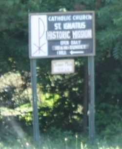 |
(#06001328) |
101 N. Lamkin Rd. 45°33′06″N 85°06′56″W / 45.551667°N 85.115556°W |
Readmond Township | |
| 36 | George Schantz House and Store | Upload image | (#86002072) |
534 Wachtel Ave. 45°22′19″N 84°57′47″W / 45.371944°N 84.963056°W |
Petoskey | |
| 37 | Frank Schapler House | Upload image | (#86002074) |
106 E. Lake St. 45°22′30″N 84°57′39″W / 45.375°N 84.960833°W |
Petoskey | |
| 38 | Seventh Day Adventist Church | Upload image | (#86002077) |
224 Michigan St. 45°22′21″N 84°57′26″W / 45.3725°N 84.957222°W |
Petoskey | |
| 39 | Shafer's Grocery and Residence | Upload image | (#86002079) |
1018 Emmet St. 45°22′04″N 84°57′33″W / 45.367778°N 84.959167°W |
Petoskey | |
| 40 | Shay Complex |  |
(#72000612) |
Main and Judd Sts. 45°25′49″N 84°59′02″W / 45.430278°N 84.983889°W |
Harbor Springs | |
| 41 | Skillagalee Light Station | 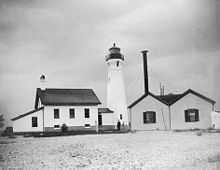 |
(#84001389) |
Southwest of Waugoshance Island 45°40′35″N 85°10′18″W / 45.676389°N 85.171667°W |
Cross Village | |
| 42 | St. Francis Solanus Mission | Upload image | (#72000614) |
W. Lake St. 45°22′32″N 84°58′03″W / 45.375556°N 84.9675°W |
Petoskey | |
| 43 | Stout House | Upload image | (#86002080) |
606 Grove St. 45°22′14″N 84°57′05″W / 45.370556°N 84.951389°W |
Petoskey | |
| 44 | Trinity Evangelical Church | Upload image | (#86002082) |
219 State St. 45°22′14″N 84°57′21″W / 45.370556°N 84.955833°W |
Petoskey | |
| 45 | Jacob VanZolenburg House | Upload image | (#86002083) |
209 State St. 45°22′20″N 84°57′32″W / 45.372222°N 84.958889°W |
Petoskey | |
| 46 | Waugoshance Light Station | 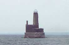 |
(#83000841) |
Northwest of Waugoshance Island 45°46′30″N 85°05′19″W / 45.775°N 85.088611°W |
Waugoshance Island | |
| 47 | J. M. Wells House | Upload image | (#86002084) |
203 W. Lake St. 45°22′29″N 84°57′45″W / 45.374722°N 84.9625°W |
Petoskey | |
| 48 | West Mitchell Street Bridge | Upload image | (#86002085) |
W. Mitchell St. at Bear River 45°22′26″N 84°57′39″W / 45.373889°N 84.960833°W |
Petoskey | |
| 49 | White Shoal Light Station | 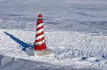 |
(#84001391) |
Northwest of Waugashance Island 45°50′32″N 85°08′07″W / 45.842222°N 85.135278°W |
Mackinaw City | |
| 50 | Wycamp Creek Site | |
(#71001022) |
Address Restricted |
Levering | |
| 51 | Zion Evangelical Lutheran Church | Upload image | (#86002086) |
610 Petoskey St. 45°22′11″N 84°57′27″W / 45.369722°N 84.9575°W |
Petoskey |
See also
| Wikimedia Commons has media related to National Register of Historic Places in Emmet County, Michigan. |
- List of Registered Historic Places in Michigan
- List of Michigan State Historic Sites in Emmet County, Michigan
References
- ↑ "National Register of Historic Places: Weekly List Actions". National Park Service, United States Department of the Interior. Retrieved on May 1, 2015.
- ↑ Numbers represent an ordering by significant words. Various colorings, defined here, differentiate National Historic Landmarks and historic districts from other NRHP buildings, structures, sites or objects.
- ↑ "National Register Information System". National Register of Historic Places. National Park Service. 2008-04-24.
- ↑ The eight-digit number below each date is the number assigned to each location in the National Register Information System database, which can be viewed by clicking the number.
| ||||||||||||

| ||||||||||||||||||||||||||