National Register of Historic Places listings in Ellis County, Kansas
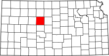
Location of Ellis County in Kansas
This is a list of the National Register of Historic Places listings in Ellis County, Kansas.
This is intended to be a complete list of the properties and districts on the National Register of Historic Places in Ellis County, Kansas, United States. The locations of National Register properties and districts for which the latitude and longitude coordinates are included below, may be seen in a Google map.[1]
There are 16 properties and districts listed on the National Register in the county. At least two other sites that were once listed have been removed.
- This National Park Service list is complete through NPS recent listings posted May 1, 2015.[2]
Current listings
| [3] | Name on the Register[4] | Image | Date listed[5] | Location | City or town | Description |
|---|---|---|---|---|---|---|
| 1 | Justus Bissing, Jr. Historic District | 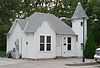 |
(#03001495) |
502-504 W. 12th St. 38°52′31″N 99°20′13″W / 38.875348°N 99.336899°W |
Hays | |
| 2 | Chestnut Street Historic District | |
(#06000621) |
Main, W. 9th, W. 10th, W. 11th, E. 11th, and E. 12th Sts. Boundary increase (listed May 24, 2011): 1302 Main St. 38°56′12″N 99°33′37″W / 38.936667°N 99.560278°W |
Hays | |
| 3 | Walter P. Chrysler House | 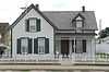 |
(#72000495) |
104 W. 10th St. 38°56′11″N 99°33′39″W / 38.936517°N 99.560937°W |
Ellis | |
| 4 | Drees House | 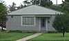 |
(#01000183) |
100 E. 19th St. 38°52′42″N 99°19′34″W / 38.878214°N 99.32603°W |
Hays | |
| 5 | Ellis Congregational Church | 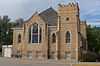 |
(#00000156) |
Eighth and Washington Sts. 38°56′26″N 99°33′38″W / 38.940496°N 99.560574°W |
Ellis | |
| 6 | First Presbyterian Church | 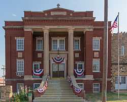 |
(#73000753) |
100 W. 7th St. 38°52′15″N 99°19′50″W / 38.870833°N 99.330556°W |
Hays | |
| 7 | Fort Fletcher Stone Arch Bridge | 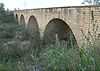 |
(#01000385) |
4.8 miles (7.7 km) south of Walker, Walker Ave. 38°47′53″N 99°04′39″W / 38.798056°N 99.0775°W |
Walker | |
| 8 | Fort Hays | 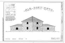 |
(#71000314) |
Frontier Historical Park 38°51′46″N 99°20′06″W / 38.862778°N 99.335°W |
Hays | |
| 9 | Gallagher House | |
(#01000184) |
310 E. 20th St. 38°52′39″N 99°19′18″W / 38.877401°N 99.321535°W |
Hays | |
| 10 | George Grant Villa | _from_NW_long_2.JPG) |
(#72000496) |
2680 Grants Villa Road[6] 38°46′05″N 99°07′10″W / 38.76808°N 99.119575°W |
Victoria | |
| 11 | Memorial City Hall | 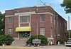 |
(#07000142) |
911 Washington St. 38°56′18″N 99°33′36″W / 38.938434°N 99.559938°W |
Ellis | |
| 12 | Merchants Bank of Ellis | 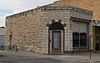 |
(#02000428) |
822 Washington St. 38°56′20″N 99°33′38″W / 38.939016°N 99.560504°W |
Ellis | |
| 13 | J.A. Mermis House | 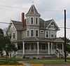 |
(#09000190) |
1401 Ash Street 38°52′33″N 99°19′56″W / 38.875971°N 99.332165°W |
Hays | |
| 14 | Phillip Hardware Store | 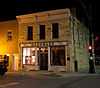 |
(#82002658) |
719 Main St. 38°52′14″N 99°19′54″W / 38.870533°N 99.331687°W |
Hays | |
| 15 | St. Fidelis Catholic Church | 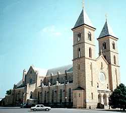 |
(#71000315) |
Southeastern corner of St. Anthony and Delaware Sts. 38°51′24″N 99°09′01″W / 38.856667°N 99.150278°W |
Victoria | |
| 16 | St. Joseph's Church and Parochial School | 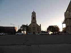 |
(#08001066) |
210 and 217 W. 13th St. 38°51′24″N 99°09′01″W / 38.856667°N 99.150278°W |
Hays |
Former listings
| [3] | Name on the Register | Image | Date listed | Date removed | Location | City or town | Summary |
|---|---|---|---|---|---|---|---|
| 1 | Krueger Building | Upload image | (#06000111) | 811 Fort St. 38°52′13″N 99°20′01″W / 38.870278°N 99.333611°W |
Hays | Demolished in 2012 | |
| 2 | Madden Elevator | Upload image | (#82002657) | 117 E. 9th St. |
Hays |
See also
| Wikimedia Commons has media related to National Register of Historic Places in Ellis County, Kansas. |
- List of National Historic Landmarks in Kansas
- National Register of Historic Places listings in Kansas
References
- ↑ The latitude and longitude information provided in this table was derived originally from the National Register Information System, which has been found to be fairly accurate for about 99% of listings. For about 1% of NRIS original coordinates, experience has shown that one or both coordinates are typos or otherwise extremely far off; some corrections may have been made. A more subtle problem causes many locations to be off by up to 150 yards, depending on location in the country: most NRIS coordinates were derived from tracing out latitude and longitudes off of USGS topographical quadrant maps created under the North American Datum of 1927, which differs from the current, highly accurate WGS84 GPS system used by most on-line maps. Chicago is about right, but NRIS longitudes in Washington are higher by about 4.5 seconds, and are lower by about 2.0 seconds in Maine. Latitudes differ by about 1.0 second in Florida. Some locations in this table may have been corrected to current GPS standards.
- ↑ "National Register of Historic Places: Weekly List Actions". National Park Service, United States Department of the Interior. Retrieved on May 1, 2015.
- ↑ 3.0 3.1 Numbers represent an ordering by significant words. Various colorings, defined here, differentiate National Historic Landmarks and historic districts from other NRHP buildings, structures, sites or objects.
- ↑ "National Register Information System". National Register of Historic Places. National Park Service. 2009-03-13.
- ↑ The eight-digit number below each date is the number assigned to each location in the National Register Information System database, which can be viewed by clicking the number.
- ↑ "George Grant Villa". Rural Kansas Tourism. Retrieved 2014-09-25.


| |||||||||||||||||||||||||||||