National Register of Historic Places listings in Eagle County, Colorado

Location of Eagle County in Colorado
This is a list of the National Register of Historic Places listings in Eagle County, Colorado.
This is intended to be a complete list of the properties and districts on the National Register of Historic Places in Eagle County, Colorado, United States. The locations of National Register properties and districts for which the latitude and longitude coordinates are included below, may be seen in a Google map.[1]
There are 13 properties and districts listed on the National Register in the county.
- This National Park Service list is complete through NPS recent listings posted May 1, 2015.[2]
Current listings
| [3] | Name on the Register[4] | Image | Date listed[5] | Location | City or town | Description |
|---|---|---|---|---|---|---|
| 1 | Archeological Site 5EA484 | Upload image | (#82002299) |
Address Restricted |
Basalt | |
| 2 | Camp Hale Site | 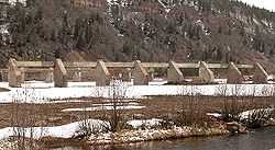 |
(#78003522) |
Between Leadville and Red Cliff 39°26′38″N 106°19′34″W / 39.444°N 106.326°W |
Leadville | Former Army base |
| 3 | Dotsero Bridge | 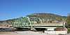 |
(#02001155) |
Interstate 70 service road at milepost 133.51 39°38′57″N 107°03′47″W / 39.649167°N 107.063056°W |
Dotsero | |
| 4 | Eagle River Bridge | 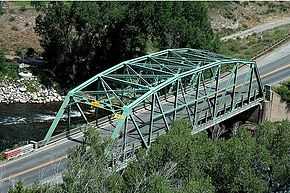 |
(#02001156) |
U.S. Highway 6 at milepost 150.24 39°39′36″N 106°48′55″W / 39.66°N 106.815278°W |
Eagle | |
| 5 | First Evangelical Lutheran Church | .JPG) |
(#93000576) |
400 2nd St. 39°38′44″N 106°57′08″W / 39.645556°N 106.952222°W |
Gypsum | |
| 6 | Notch Mountain Shelter | Upload image | (#15000059) |
Notch Mtn. Summit, White River NF 39°28′41″N 106°27′35″W / 39.4781°N 106.4596°W |
Minturn vicinity | |
| 7 | Red Cliff Bridge | 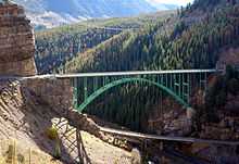 |
(#85000204) |
U.S. Highway 24 39°30′29″N 106°22′34″W / 39.508056°N 106.376111°W |
Red Cliff | |
| 8 | State Bridge | 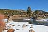 |
(#85001401) |
Off State Highway 131 39°51′29″N 106°38′54″W / 39.858056°N 106.648333°W |
State Bridge | |
| 9 | Tigiwon Community House | Upload image | (#15000060) |
FSR 707, Holy Cross Dist., White River NF 39°31′24″N 106°25′14″W / 39.5232°N 106.4206°W |
Minturn vicinity | |
| 10 | Upper Brush Creek School | Upload image | (#15000126) |
Between Coulter Meadow & W. Brush Cr. Rds. 39°32′09″N 106°45′10″W / 39.5357°N 106.7528°W |
Eagle vicinity | In/near Sylvan Lake State Park |
| 11 | Waterwheel | 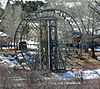 |
(#77000372) |
Southeast of McCoy at the Colorado River 39°54′10″N 106°43′00″W / 39.902778°N 106.716667°W |
McCoy | |
| 12 | Woods Lake Resort | Upload image | (#88001226) |
11 miles (18 km) north of Thomasville at Woods Lake 39°25′32″N 106°37′35″W / 39.425556°N 106.626389°W |
Thomasville | |
| 13 | Yarmony Archeological Site | Upload image | (#91000615) |
Address Restricted |
Radium |
Former listing
| [3] | Name on the Register | Image | Date listed | Date removed | Location | City or town | Summary |
|---|---|---|---|---|---|---|---|
| 1 | Wolcott Bridge | Upload image | (#02001157) | State Highway 131 at milepost 0.07 39°42′06″N 106°40′39″W / 39.701667°N 106.6775°W |
Wolcott | Part of the Highway Bridges in Colorado Multiple Property Submission | |
| 2 | Wolcott Stage Station | 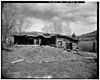 |
(#75000518) | N bank of Eagle River off SH 131 |
Wolcott | Also known as the Bocco House |
See also
| Wikimedia Commons has media related to National Register of Historic Places in Eagle County, Colorado. |
- List of National Historic Landmarks in Colorado
- National Register of Historic Places listings in Colorado
References
- ↑ The latitude and longitude information provided in this table was derived originally from the National Register Information System, which has been found to be fairly accurate for about 99% of listings. For about 1% of NRIS original coordinates, experience has shown that one or both coordinates are typos or otherwise extremely far off; some corrections may have been made. A more subtle problem causes many locations to be off by up to 150 yards, depending on location in the country: most NRIS coordinates were derived from tracing out latitude and longitudes off of USGS topographical quadrant maps created under the North American Datum of 1927, which differs from the current, highly accurate WGS84 GPS system used by most on-line maps. Chicago is about right, but NRIS longitudes in Washington are higher by about 4.5 seconds, and are lower by about 2.0 seconds in Maine. Latitudes differ by about 1.0 second in Florida. Some locations in this table may have been corrected to current GPS standards.
- ↑ "National Register of Historic Places: Weekly List Actions". National Park Service, United States Department of the Interior. Retrieved on May 1, 2015.
- ↑ 3.0 3.1 Numbers represent an ordering by significant words. Various colorings, defined here, differentiate National Historic Landmarks and historic districts from other NRHP buildings, structures, sites or objects.
- ↑ "National Register Information System". National Register of Historic Places. National Park Service. 2008-04-24.
- ↑ The eight-digit number below each date is the number assigned to each location in the National Register Information System database, which can be viewed by clicking the number.
| ||||||||||||||||||||||||||
| |||||||||||||||||||||||||