| [3] |
Name on the Register[4] |
Image |
Date listed[5] |
Location |
City or town |
Description |
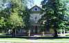
|---|
| 1 |
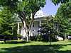
Garvin Cavaness House |
|
01980-05-23-0000May 23, 1980
(#80000775) |
404 S. Main St.
33°37′22″N 91°47′30″W / 33.622778°N 91.791667°W / 33.622778; -91.791667 (Garvin Cavaness House) |
Monticello |
|
| 2 |
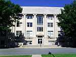
Drew County Courthouse |
|
01997-10-17-0000October 17, 1997
(#97001226) |
210 S. Main St.
33°37′36″N 91°47′29″W / 33.626667°N 91.791389°W / 33.626667; -91.791389 (Drew County Courthouse) |
Monticello |
|
| 3 |
Champ Grubbs House |
Upload image |
01992-11-20-0000November 20, 1992
(#92001619) |
Highway 172 west of New Hope
33°30′46″N 91°56′03″W / 33.512778°N 91.934167°W / 33.512778; -91.934167 (Champ Grubbs House) |
New Hope |
|
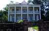
| 4 |
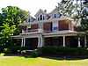
Robert Lee Hardy House |
|
01982-04-26-0000April 26, 1982
(#82002113) |
207 S. Main St.
33°37′36″N 91°47′26″W / 33.626667°N 91.790556°W / 33.626667; -91.790556 (Robert Lee Hardy House) |
Monticello |
|
| 5 |
Hotchkiss House |
Upload image |
01976-12-12-0000December 12, 1976
(#76000404) |
509 N. Boyd St.
33°37′53″N 91°47′39″W / 33.631389°N 91.794167°W / 33.631389; -91.794167 (Hotchkiss House) |
Monticello |
|
| 6 |
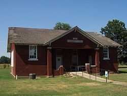
Jerome Elementary School No. 22 |
|
02005-09-28-0000September 28, 2005
(#05001068) |
N. Louisiana Boulevard
33°24′11″N 91°28′08″W / 33.403056°N 91.468889°W / 33.403056; -91.468889 (Jerome Elementary School No. 22) |
Jerome |
|
| 7 |
Lambert House |
|
01983-12-22-0000December 22, 1983
(#83003545) |
204 W. Jackson St.
33°37′35″N 91°47′34″W / 33.626389°N 91.792778°W / 33.626389; -91.792778 (Lambert House) |
Monticello |
|
| 8 |
Look See Tree |
Upload image |
02008-01-23-0000January 23, 2008
(#07001427) |
Southwestern corner of the junction of Highway 83 and Pleasant Springs Rd.
33°47′10″N 91°44′59″W / 33.786111°N 91.749722°W / 33.786111; -91.749722 (Look See Tree) |
Coleman |
|
| 9 |
Monticello Commercial Historic District |
|
02011-09-23-0000September 23, 2011
(#11000688) |
Bounded roughly by Trotter Ave., Edwards St., Railroad Ave. & Chester St.
33°37′46″N 91°47′27″W / 33.629444°N 91.790833°W / 33.629444; -91.790833 (Monticello Commercial Historic District) |
Monticello |
|
| 10 |
Monticello Confederate Monument |
Upload image |
01996-04-26-0000April 26, 1996
(#96000449) |
Oakland Cemetery, east of the junction of Oakland Ave. and Hyatt St.
33°38′04″N 91°47′52″W / 33.634444°N 91.797778°W / 33.634444; -91.797778 (Monticello Confederate Monument) |
Monticello |
|
| 11 |
Monticello North Main Street Historic District |
|
01979-02-18-0000February 18, 1979
(#79000437) |
Irregular pattern along Westwood Ave. and N. Main St.
33°38′01″N 91°47′27″W / 33.633611°N 91.790833°W / 33.633611; -91.790833 (Monticello North Main Street Historic District) |
Monticello |
|
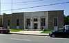
| 12 |
Monticello Post Office |
|
01998-08-14-0000August 14, 1998
(#98000920) |
211 W. Gaines St.
33°37′46″N 91°47′31″W / 33.629444°N 91.791944°W / 33.629444; -91.791944 (Monticello Post Office) |
Monticello |
|
| 13 |
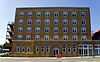
Ridgeway Hotel Historic District |
|
02009-01-22-0000January 22, 2009
(#08000952) |
200-206 E. Gaines St.
33°37′44″N 91°47′24″W / 33.628889°N 91.79°W / 33.628889; -91.79 (Ridgeway Hotel Historic District) |
Monticello |
|
| 14 |
Rough and Ready Cemetery |
Upload image |
01999-11-22-0000November 22, 1999
(#99001376) |
Approximately 1 mile southeast of the Monticello Civic Center on Highway 19
33°36′50″N 91°47′21″W / 33.613889°N 91.789167°W / 33.613889; -91.789167 (Rough and Ready Cemetery) |
Monticello |
|
| 15 |
St. Mary's Episcopal Church |
|
01996-04-04-0000April 4, 1996
(#96000352) |
115 S. Main St.
33°37′39″N 91°47′26″W / 33.6275°N 91.790556°W / 33.6275; -91.790556 (St. Mary's Episcopal Church) |
Monticello |
|
| 16 |
Saline Cemetery |
Upload image |
02011-06-15-0000June 15, 2011
(#11000353) |
.3 miles south of the junction of US 278 & Allis Rd.
33°37′11″N 91°54′30″W / 33.6197°N 91.9083°W / 33.6197; -91.9083 (Saline Cemetery) |
Wilmar vicinity |
|
| 17 |
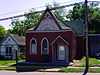
Selma Methodist Church |
Upload image |
01972-09-22-0000September 22, 1972
(#72000202) |
North of Highway 4 in Selma
33°41′52″N 91°34′11″W / 33.697778°N 91.569722°W / 33.697778; -91.569722 (Selma Methodist Church) |
Selma |
|
| 18 |
Selma Rosenwald School |
Upload image |
02006-03-02-0000March 2, 2006
(#06000069) |
Selma-Collins Rd., approximately 0.25 miles south of U.S. Route 278
33°40′30″N 91°33′58″W / 33.675°N 91.566111°W / 33.675; -91.566111 (Selma Rosenwald School) |
Selma |
|
| 19 |
Taylor Log House and Site |
Upload image |
01995-10-16-0000October 16, 1995
(#95001168) |
Highway 138 west of Winchester
33°46′11″N 91°33′04″W / 33.769722°N 91.551111°W / 33.769722; -91.551111 (Taylor Log House and Site) |
Winchester |
|
| 20 |
Frank Tillar Memorial Methodist Episcopal Church, South |
Upload image |
01997-06-04-0000June 4, 1997
(#97000525) |
W. Railroad St., north of Highway 277
33°42′37″N 91°27′13″W / 33.710278°N 91.453611°W / 33.710278; -91.453611 (Frank Tillar Memorial Methodist Episcopal Church, South) |
Tillar |
|
| 21 |
Veasey-DeArmond House |
Upload image |
01989-09-14-0000September 14, 1989
(#89001424) |
Highway 81, 15 miles north of Monticello
33°30′41″N 91°51′31″W / 33.511389°N 91.858611°W / 33.511389; -91.858611 (Veasey-DeArmond House) |
Lacey |
|