National Register of Historic Places listings in Douglas County, Kansas
Location of Douglas County in Kansas
This is a list of the National Register of Historic Places listings in Douglas County, Kansas.
This is intended to be a complete list of the properties and districts on the National Register of Historic Places in Douglas County, Kansas, United States. The locations of National Register properties and districts for which the latitude and longitude coordinates are included below, may be seen in a Google map.[1]
There are 77 properties and districts listed on the National Register in the county, including 3 National Historic Landmarks.
- This National Park Service list is complete through NPS recent listings posted May 1, 2015.[2]
Current listings
| [3] | Name on the Register[4] | Image | Date listed[5] | Location | City or town | Description |
|---|---|---|---|---|---|---|
| 1 | Ralph and Cloyd Achning House | 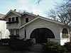 |
(#87001030) |
846 Missouri St. 38°58′04″N 95°14′50″W / 38.967778°N 95.247222°W |
Lawrence | |
| 2 | Bailey Hall | 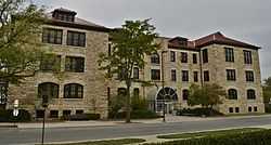 |
(#01001122) |
Junction of Jayhawk Dr. and Sunflower Rd. 38°57′28″N 95°14′46″W / 38.957778°N 95.246111°W |
Lawrence | |
| 3 | Barnes Apple Barn | 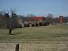 |
(#06000966) |
714 E. 1728 Rd. 38°50′34″N 95°10′53″W / 38.842778°N 95.181389°W |
Baldwin City | |
| 4 | George and Annie Bell House | 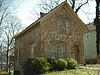 |
(#83000423) |
1008 Ohio St. 38°57′55″N 95°15′06″W / 38.965278°N 95.251667°W |
Lawrence | |
| 5 | Benedict House | 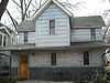 |
(#91001978) |
923 Tennessee St. 38°57′59″N 95°14′23″W / 38.966389°N 95.239722°W |
Lawrence | |
| 6 | Beni Israel Cemetery | 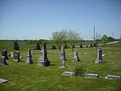 |
(#12001118) |
1301 East 2100 Road 38°55′41″N 95°06′45″W / 38.928194°N 95.112582°W |
Eudora | |
| 7 | Black Jack Battlefield | 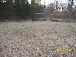 |
(#04000365) |
U.S. Route 56 and County Road 2000, 3 miles (4.8 km) east of Baldwin City 38°45′56″N 95°07′45″W / 38.765556°N 95.129167°W |
Baldwin City | National Historic Landmark designation October 16, 2012 |
| 8 | Col. James Blood House | 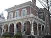 |
(#72000493) |
1015 Tennessee St. 38°57′54″N 95°14′22″W / 38.965°N 95.239444°W |
Lawrence | |
| 9 | Breezedale Historic District | 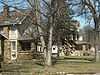 |
(#07001478) |
2301-2401 Massachusetts St. 38°56′30″N 95°14′09″W / 38.941667°N 95.235833°W |
Lawrence | |
| 10 | Case Library | 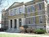 |
(#86001232) |
Baker University, Eighth and Grove 38°46′39″N 95°11′20″W / 38.7775°N 95.188889°W |
Baldwin City | |
| 11 | Chicken Creek Bridge | 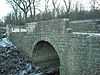 |
(#90000298) |
Over Chicken Creek, southeast of Lone Star 38°51′11″N 95°20′35″W / 38.853056°N 95.343056°W |
Lone Star | |
| 12 | Clearfield School--District 58 | 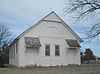 |
(#13001037) |
2162 N. 600 Rd. Coordinates missing |
Baldwin City | Part of the Public Schools of Kansas MPS |
| 13 | Clinton School District 25 | 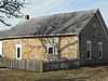 |
(#96001160) |
1180 N. 604 East Rd. 38°55′16″N 95°23′24″W / 38.921111°N 95.39°W |
Lawrence | Now the Clinton city hall |
| 14 | Coal Creek Library | .JPG) |
(#03001257) |
698 E. 1719 Rd. 38°50′24″N 95°10′57″W / 38.840071°N 95.182632°W |
Vinland | |
| 15 | Constitution Hall | 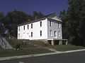 |
(#71000312) |
Elmore St. between Woodson and 3rd Sts. 39°02′44″N 95°23′40″W / 39.045556°N 95.394444°W |
Lecompton | |
| 16 | Double Hyperbolic Paraboloid House | 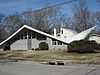 |
(#07000605) |
934 W. 21st. St. 38°56′47″N 95°14′48″W / 38.946389°N 95.246667°W |
Lawrence | |
| 17 | Douglas County Courthouse | 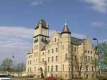 |
(#75000708) |
Southeastern corner of Massachusetts and 11th Sts. 38°57′48″N 95°14′07″W / 38.963333°N 95.235278°W |
Lawrence | |
| 18 | Charles Duncan House | 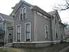 |
(#86001215) |
933 Tennessee St. 38°58′01″N 95°14′59″W / 38.966944°N 95.249722°W |
Lawrence | |
| 19 | Dyche Hall, University of Kansas | 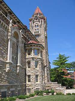 |
(#74000829) |
14th St. and Oread Ave., University of Kansas campus 38°57′31″N 95°14′38″W / 38.958611°N 95.243889°W |
Lawrence | |
| 20 | East Lawrence Industrial Historic District |  |
(#07001250) |
619 E. 8th St., 804-846 Pennsylvania St., and 716 E. 9th St. 38°58′07″N 95°13′44″W / 38.968502°N 95.228916°W |
Lawrence | |
| 21 | Eldridge House Hotel | 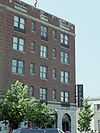 |
(#86003278) |
Seventh and Massachusetts Sts. 38°58′17″N 95°14′05″W / 38.971389°N 95.234722°W |
Lawrence | |
| 22 | English Lutheran Church | .JPG) |
(#95000945) |
1040 New Hampshire St. 38°57′34″N 95°13′41″W / 38.959444°N 95.228056°W |
Lawrence | |
| 23 | Fernand-Strong House | Upload image | (#08000614) |
1515 University Dr. 38°57′38″N 95°15′11″W / 38.960556°N 95.253056°W |
Lawrence | |
| 24 | Charles & Elizabeth Haskell French House | Upload image | (#12000844) |
1300 Haskell Ave. 38°57′35″N 95°13′22″W / 38.959642°N 95.222905°W |
Lawrence | |
| 25 | Eugene F. Goodrich House | 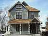 |
(#01001123) |
1711 Massachusetts St. 38°57′10″N 95°14′11″W / 38.952778°N 95.236389°W |
Lawrence | |
| 26 | Green Hall, University of Kansas | 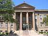 |
(#74000830) |
Jayhawk Dr. 38°57′29″N 95°14′40″W / 38.958056°N 95.244444°W |
Lawrence | Lippencott Hall since 1979 |
| 27 | Michael D. Greenlee House | 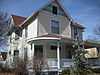 |
(#03001387) |
947 Louisiana St. 38°58′01″N 95°14′36″W / 38.966944°N 95.243333°W |
Lawrence | |
| 28 | Hancock (12th Street) Historic District | 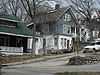 |
(#04000726) |
Roughly along W. 12th St., from Oread Ave. to Mississippi St. 38°57′42″N 95°14′39″W / 38.961667°N 95.244167°W |
Lawrence | |
| 29 | Haskell Institute | 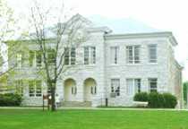 |
(#66000342) |
Southern end of Barker Ave.[6] 38°56′19″N 95°14′00″W / 38.938611°N 95.233333°W |
Lawrence | |
| 30 | Edward House House | 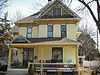 |
(#07000316) |
1646 Massachusetts St. 38°57′13″N 95°14′08″W / 38.953611°N 95.235556°W |
Lawrence | |
| 31 | Kibbee Farmstead | Upload image | (#13000165) |
1500 Haskell Ave. 38°57′24″N 95°13′23″W / 38.956605°N 95.222977°W |
Lawrence | |
| 32 | Lane University |  |
(#71000313) |
Eastern side of Lecompton 39°02′42″N 95°23′29″W / 39.045°N 95.391389°W |
Lecompton | Now the Territorial Capital Museum |
| 33 | Lawrence's Downtown Historic District | 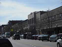 |
(#04000685) |
Generally along Massachusetts St. between 6th Ave. and S. Park St. 38°57′59″N 95°14′10″W / 38.966389°N 95.236111°W |
Lawrence | |
| 34 | Ludington House |  |
(#71000310) |
1613 Tennessee St. 38°57′15″N 95°14′23″W / 38.954167°N 95.239722°W |
Lawrence | |
| 35 | George K. Mackie House | 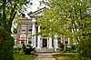 |
(#09000497) |
1941 Massachusetts St. 38°56′58″N 95°14′09″W / 38.949333°N 95.235925°W |
Lawrence | |
| 36 | Handel T. Martin House | Upload image | (#14000830) |
1709 Louisiana St. 38°57′12″N 95°14′30″W / 38.9532°N 95.2417°W |
Lawrence | |
| 37 | Witter S. McCurdy House | 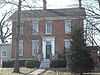 |
(#01001124) |
909 W. 6th St. 38°58′22″N 95°14′45″W / 38.972856°N 95.245739°W |
Lawrence | |
| 38 | Robert H. Miller House | 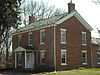 |
(#84001235) |
1111 E. 19th St. 38°56′59″N 95°13′16″W / 38.949722°N 95.221111°W |
Lawrence | |
| 39 | Dr. Frederic D. Morse House | 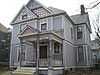 |
(#91000469) |
1041 Tennessee St. 38°57′52″N 95°14′20″W / 38.964444°N 95.238889°W |
Lawrence | |
| 40 | North Rhode Island Street Historic Residential District | 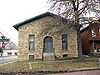 |
(#04000686) |
700-1144, 901-1047, 1201-1215 Rhode Island St. 38°57′41″N 95°14′00″W / 38.961389°N 95.233333°W |
Lawrence | |
| 41 | Old Castle Hall | 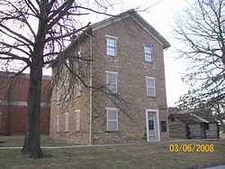 |
(#71000309) |
513 5th St. 38°46′38″N 95°11′04″W / 38.777222°N 95.184444°W |
Baldwin City | |
| 42 | Old Lawrence City Hall | 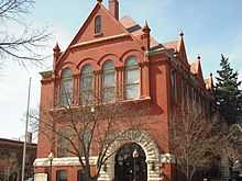 |
(#71000311) |
1047 Massachusetts St. 38°57′51″N 95°14′09″W / 38.964167°N 95.235833°W |
Lawrence | Built 1885-88 for Watkins National Bank; city hall, 1929-1970; Watkins Community Museum since 1975. |
| 43 | Old Lawrence City Library | 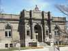 |
(#75000709) |
Northwestern corner of 9th and Vermont Sts. 38°58′04″N 95°14′15″W / 38.967778°N 95.2375°W |
Lawrence | |
| 44 | Old West Lawrence Historic District | .JPG) |
(#72000494) |
Bounded roughly by Tennessee, 8th, Indiana, and 6th Sts. 38°58′15″N 95°14′27″W / 38.970833°N 95.240833°W |
Lawrence | |
| 45 | Oread Historic District |  |
(#07001064) |
Roughly between W. 9th & 12th Sts., and the alleys behind Louisiana & Kentucky Sts. 38°57′54″N 95°14′24″W / 38.964865°N 95.239967°W |
Lawrence | |
| 46 | Parmenter Memorial Hall |  |
(#77000579) |
8th and Dearborn Sts. 38°46′42″N 95°11′15″W / 38.778333°N 95.1875°W |
Baldwin City | |
| 47 | Charles Pilla House |  |
(#74000828) |
615 Elm St. 38°56′52″N 95°05′53″W / 38.947778°N 95.098056°W |
Eudora | |
| 48 | Pinckney I Historic District |  |
(#04000688) |
Roughly bounded by W. 5th St., Tennessee St., W. 6th St., and Louisiana St., with 501-533 Louisiana St. and 444-445 W. St. 38°58′27″N 95°14′30″W / 38.974167°N 95.241667°W |
Lawrence | |
| 49 | Pinckney II Historic District | 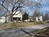 |
(#04000689) |
Roughly bounded by W. 3rd St., Louisiana St., W. 4th St. and Mississippi St. 38°58′39″N 95°14′40″W / 38.9775°N 95.244444°W |
Lawrence | |
| 50 | Plymouth Congregational Church | 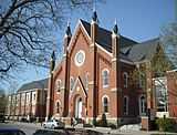 |
(#09000674) |
925 Vermont Street 38°58′00″N 95°14′13″W / 38.966616°N 95.23707°W |
Lawrence | |
| 51 | Priestly House | 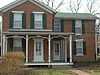 |
(#88000199) |
1505 Kentucky St. 38°57′26″N 95°14′18″W / 38.957222°N 95.238333°W |
Lawrence | |
| 52 | William A. Quayle House | 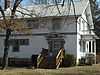 |
(#94001624) |
210 N. 6th St. 38°47′04″N 95°11′07″W / 38.784444°N 95.185278°W |
Baldwin City | |
| 53 | Samuel A. Riggs House | 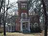 |
(#77000580) |
1500 Pennsylvania St. 38°57′24″N 95°13′43″W / 38.956667°N 95.228611°W |
Lawrence | |
| 54 | John N. Roberts House | 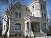 |
(#74000831) |
1307 Massachusetts St. 38°57′36″N 95°14′11″W / 38.96°N 95.236389°W |
Lawrence | Also known as the Castle Tea Room |
| 55 | St. Luke African Methodist Episcopal Church | 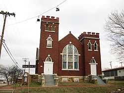 |
(#05001240) |
900 New York St. 38°58′03″N 95°13′50″W / 38.9675°N 95.230556°W |
Lawrence | |
| 56 | Santa Fe Depot | 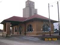 |
(#83000424) |
1601 High St. 38°46′29″N 95°12′02″W / 38.774722°N 95.200556°W |
Baldwin City | |
| 57 | Santa Fe Trail-Douglas County Trail Segments | 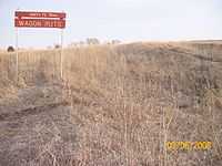 |
(#02001262) |
U.S. Route 56, 2.5 miles (4.0 km) east of Baldwin City 38°46′01″N 95°07′46″W / 38.766944°N 95.129444°W |
Baldwin City | |
| 58 | Snow House | 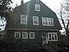 |
(#96000947) |
706 W. 12th St. 38°57′44″N 95°13′54″W / 38.962222°N 95.231667°W |
Lawrence | |
| 59 | South Rhode Island and New Hampshire Street Historic Residential District | Upload image | (#04000687) |
1120-1340 E. Rhode Island St; 1301-1345 W. Rhode Island St.; 1300-1346 E. New Hampshire St.; 1301-1347 W. New Hampshire St. 38°57′35″N 95°14′01″W / 38.959722°N 95.233611°W |
Lawrence | |
| 60 | Spooner Hall, University of Kansas |  |
(#74000832) |
14th St. and Oread Ave. on the University of Kansas campus 38°57′30″N 95°14′48″W / 38.958333°N 95.246667°W |
Lawrence | |
| 61 | Judge Nelson T. Stephens House | Upload image | (#82002655) |
340 N. Michigan St. 38°59′23″N 95°14′56″W / 38.989722°N 95.248889°W |
Lawrence | |
| 62 | Stoebener Barn | Upload image | (#88003083) |
Southwest of Worden 38°46′23″N 95°20′52″W / 38.773056°N 95.347778°W |
Baldwin City | |
| 63 | Stony Point Evangelical Lutheran Church | 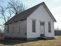 |
(#06001168) |
1575 N. 600 Rd. 38°49′30″N 95°12′38″W / 38.825°N 95.210556°W |
Baldwin City | |
| 64 | Strong Hall | 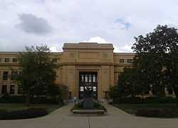 |
(#98001174) |
213 Strong Hall, University of Kansas, at the junction of Jayhawk Dr. and Poplar Ln. 38°57′35″N 95°14′48″W / 38.959722°N 95.246667°W |
Lawrence | |
| 65 | Lucy Hobbs Taylor Building | 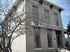 |
(#82002656) |
809 Vermont 38°58′05″N 95°14′17″W / 38.968056°N 95.238056°W |
Lawrence | |
| 66 | Trail Park and Trail Park DAR Marker | 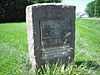 |
(#13000486) |
NW. jct. of E 1700 & N 400 Rds. 38°47′28″N 95°11′12″W / 38.791046°N 95.186685°W |
Baldwin City | Santa Fe Trail Multiple Property Submission |
| 67 | US Post Office-Lawrence | 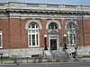 |
(#02001265) |
645 New Hampshire 38°58′17″N 95°14′06″W / 38.971389°N 95.235°W |
Lawrence | Now offices of The World Company and the Lawrence Journal-World |
| 68 | United Presbyterian Center | Upload image | (#09000350) |
1204 Oread Ave. 38°57′38″N 95°14′34″W / 38.960503°N 95.242711°W |
Lawrence | |
| 69 | University of Kansas East Historic District | Upload image | (#13001038) |
Roughly bounded by Oread & Sunnyside Aves., Jayhawk Blvd., Lilac Ln., Pearson Pl., Louisiana & W. 13th Sts. Coordinates missing |
Lawrence | |
| 70 | University of Kansas Historic District | 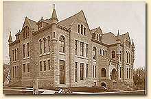 |
(#13000167) |
Roughly bounded by W Campus Rd., S edge of Jayhawk Blvd., Sunnyside Ave., Lilac Ln., Oread Ave., and W 13th St. 38°57′29″N 95°14′52″W / 38.958116°N 95.247862°W |
Lawrence | |
| 71 | Upper Wakarusa River Crossing | 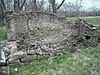 |
(#13001039) |
1180 E. 1400 Rd. Coordinates missing |
Lawrence vicinity | |
| 72 | John Palmer Usher House |  |
(#75000710) |
1425 Tennessee St. 38°57′27″N 95°14′23″W / 38.9575°N 95.239722°W |
Lawrence | |
| 73 | Vermilya-Boener House |  |
(#91001961) |
Northwest of junction of U.S. Routes 24, 40, and 59 39°00′56″N 95°14′33″W / 39.015556°N 95.2425°W |
Lawrence | |
| 74 | Vinland Fair Association Fairgrounds Exhibit Building | Upload image | (#03001466) |
1736 N. 700 Rd. 38°50′34″N 95°09′59″W / 38.842778°N 95.166389°W |
Vinland | |
| 75 | Vinland Grange Hall |  |
(#00000037) |
Junction of Oak and Main Sts. 38°50′21″N 95°10′56″W / 38.839167°N 95.182222°W |
Vinland | |
| 76 | Vinland Presbyterian Church | 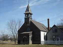 |
(#03000707) |
697 E. 1725 Rd. 38°50′25″N 95°10′56″W / 38.840280°N 95.182120°W |
Vinland | |
| 77 | S.T. Zimmerman House | 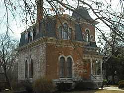 |
(#74000833) |
304 Indiana St. 38°58′44″N 95°13′52″W / 38.978889°N 95.231111°W |
Lawrence |
Former listings
| [3] | Name on the Register | Image | Date listed | Date removed | Location | City or town | Summary |
|---|---|---|---|---|---|---|---|
| 1 | J.C. Steele House | Upload image | (#74000827) | 1 mi. east of Clinton 38°54′35″N 95°22′13″W / 38.909707°N 95.370276°W |
Clinton | Built in 1866. Despite plans to renovate the house, it was demolished in 1981. Only the foundation and front stairs remain. |
See also
| Wikimedia Commons has media related to National Register of Historic Places in Douglas County, Kansas. |
- List of National Historic Landmarks in Kansas
- National Register of Historic Places listings in Kansas
References
- ↑ The latitude and longitude information provided in this table was derived originally from the National Register Information System, which has been found to be fairly accurate for about 99% of listings. For about 1% of NRIS original coordinates, experience has shown that one or both coordinates are typos or otherwise extremely far off; some corrections may have been made. A more subtle problem causes many locations to be off by up to 150 yards, depending on location in the country: most NRIS coordinates were derived from tracing out latitude and longitudes off of USGS topographical quadrant maps created under the North American Datum of 1927, which differs from the current, highly accurate WGS84 GPS system used by most on-line maps. Chicago is about right, but NRIS longitudes in Washington are higher by about 4.5 seconds, and are lower by about 2.0 seconds in Maine. Latitudes differ by about 1.0 second in Florida. Some locations in this table may have been corrected to current GPS standards.
- ↑ "National Register of Historic Places: Weekly List Actions". National Park Service, United States Department of the Interior. Retrieved on May 1, 2015.
- ↑ 3.0 3.1 Numbers represent an ordering by significant words. Various colorings, defined here, differentiate National Historic Landmarks and historic districts from other NRHP buildings, structures, sites or objects.
- ↑ "National Register Information System". National Register of Historic Places. National Park Service. 2009-03-13.
- ↑ The eight-digit number below each date is the number assigned to each location in the National Register Information System database, which can be viewed by clicking the number.
- ↑ The NRIS lists the site as "address unknown" but provides coordinates; this address is derived from those coordinates


| |||||||||||||||||||||||||