| [3] |
Name on the Register |
Image |
Date listed[4] |
Location |
City or town |
Description |
|---|
| 1 |
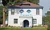
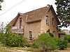
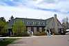
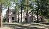
American Federation of Human Rights Headquarters |
|
01998-03-19-0000March 19, 1998
(#98000247) |
9070 S. Douglas Boulevard
39°13′44″N 104°53′15″W / 39.228889°N 104.8875°W / 39.228889; -104.8875 (American Federation of Human Rights Headquarters) |
Larkspur |
|
| 2 |
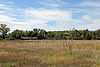
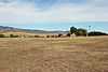
Bear Canon Agricultural District |
|
01975-10-29-0000October 29, 1975
(#75000517) |
South of Denver on both sides of State Highway 105 from State Highway 67 south to Jarre Creek
39°23′46″N 104°57′41″W / 39.396111°N 104.961389°W / 39.396111; -104.961389 (Bear Canon Agricultural District) |
Sedalia |
|
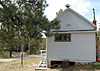
| 3 |
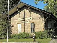
Castle Rock Depot |
|
01974-10-11-0000October 11, 1974
(#74000575) |
420 Elbert St.
39°22′27″N 104°51′43″W / 39.374167°N 104.861944°W / 39.374167; -104.861944 (Castle Rock Depot) |
Castle Rock |
|
| 4 |
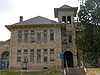
Castle Rock Elementary School |
|
01984-09-20-0000September 20, 1984
(#84000827) |
3rd and Cantril Sts.
39°22′22″N 104°51′19″W / 39.372778°N 104.855278°W / 39.372778; -104.855278 (Castle Rock Elementary School) |
Castle Rock |
|
| 5 |
Cherokee Ranch |
Upload image |
01994-10-21-0000October 21, 1994
(#94001228) |
North of County Road 85 and south of Daniels Park Rd.
39°27′20″N 104°55′36″W / 39.455556°N 104.926667°W / 39.455556; -104.926667 (Cherokee Ranch) |
Sedalia |
|
| 6 |
Cherry Creek Bridge |
|
02002-10-15-0000October 15, 2002
(#02001147) |
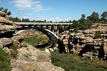
State Highway 83 at milepost 46.30
39°19′52″N 104°44′02″W / 39.331111°N 104.733889°W / 39.331111; -104.733889 (Cherry Creek Bridge) |
Franktown |
|
| 7 |
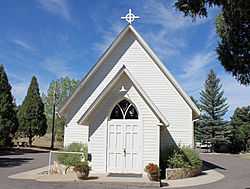
Church of St. Philip-in-the-Field and Bear Canon Cemetery |
|
01973-04-11-0000April 11, 1973
(#73000471) |
5 miles (8.0 km) south of Sedalia on State Highway 105
39°22′05″N 104°57′33″W / 39.368056°N 104.959167°W / 39.368056; -104.959167 (Church of St. Philip-in-the-Field and Bear Canon Cemetery) |
Sedalia |
|
| 8 |
Daniels Park |
|
01995-06-30-0000June 30, 1995
(#95000795) |
Along Douglas County Road 67 northeast of Sedalia
39°28′50″N 104°55′37″W / 39.480556°N 104.926944°W / 39.480556; -104.926944 (Daniels Park) |
Sedalia |
|
| 9 |
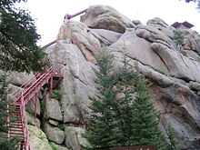
Devils Head Lookout |
|
02003-06-13-0000June 13, 2003
(#03000518) |
South Platte District in the Pike National Forest
39°15′37″N 105°06′03″W / 39.260278°N 105.100833°W / 39.260278; -105.100833 (Devils Head Lookout) |
Sedalia |
|
| 10 |
Evans Homestead Rural Historic Landscape |
Upload image |
02012-04-25-0000April 25, 2012
(#12000226) |
Address Restricted
|
Franktown vicinity |
|
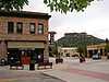
| 11 |
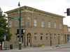
First National Bank of Douglas County |
|
01995-04-14-0000April 14, 1995
(#95000440) |
300 Wilcox St.
39°22′21″N 104°51′33″W / 39.3725°N 104.859167°W / 39.3725; -104.859167 (First National Bank of Douglas County) |
Castle Rock |
|
| 12 |
Franktown Cave |
Upload image |
02006-02-01-0000February 1, 2006
(#05001561) |
Address Restricted
|
Franktown |
|
| 13 |
Glen Grove School |
Upload image |
01974-11-05-0000November 5, 1974
(#74000576) |
North of Palmer Lake off Perry Park Rd.
39°15′38″N 104°57′02″W / 39.260556°N 104.950556°W / 39.260556; -104.950556 (Glen Grove School) |
Palmer Lake |
|
| 14 |
Benjamin Hammar House |
|
01993-02-03-0000February 3, 1993
(#92001847) |
203 Cantril St.
39°22′18″N 104°51′22″W / 39.371667°N 104.856111°W / 39.371667; -104.856111 (Benjamin Hammar House) |
Castle Rock |
|
| 15 |
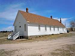
Indian Park School |
|
01978-02-08-0000February 8, 1978
(#78000857) |
10 miles (16 km) west of Sedalia on State Highway 67
39°22′49″N 105°04′52″W / 39.380278°N 105.081111°W / 39.380278; -105.081111 (Indian Park School) |
Sedalia |
|
| 16 |
Keystone Hotel |
|
01997-06-20-0000June 20, 1997
(#97000594) |
219 and 223 4th St.
39°22′25″N 104°51′36″W / 39.373611°N 104.86°W / 39.373611; -104.86 (Keystone Hotel) |
Castle Rock |
|
| 17 |
John Kinner House |
Upload image |
01974-10-11-0000October 11, 1974
(#74000578) |
6694 Perry Park Rd.
39°16′18″N 104°57′25″W / 39.271667°N 104.956944°W / 39.271667; -104.956944 (John Kinner House) |
Sedalia |
|
| 18 |
Lamb Spring |
Upload image |
01997-03-13-0000March 13, 1997
(#97000208) |
Address Restricted
|
Littleton |
|
| 19 |
Louviers Village |
|
01999-07-02-0000July 2, 1999
(#99000710) |
Louviers Boulevard, Hillcrest Dr., Triangle Dr., Main St., Valley View St., and 1st, 2nd, 3rd and 4th Sts.
39°28′36″N 105°00′22″W / 39.476667°N 105.006111°W / 39.476667; -105.006111 (Louviers Village) |
Louviers |
|
| 20 |
Louviers Village Club |
|
01995-09-22-0000September 22, 1995
(#95001117) |
Junction of Louviers Boulevard and 1st St.
39°28′34″N 105°00′23″W / 39.476111°N 105.006389°W / 39.476111; -105.006389 (Louviers Village Club) |
Louviers |
|
| 21 |
Pike's Peak Grange No. 163 |
|
01990-10-01-0000October 1, 1990
(#90001502) |
3093 State Highway 83
39°24′32″N 104°45′42″W / 39.408889°N 104.761667°W / 39.408889; -104.761667 (Pike's Peak Grange No. 163) |
Franktown |
|
| 22 |
Ben Quick Ranch and Fort |
|
01974-10-01-0000October 1, 1974
(#74000577) |
6695 W. Plum Creek Rd.
39°15′52″N 104°57′10″W / 39.264444°N 104.952778°W / 39.264444; -104.952778 (Ben Quick Ranch and Fort) |
Palmer Lake |
|
| 23 |
Roxborough State Park Archaeological District |
|
01983-01-27-0000January 27, 1983
(#83001316) |
Address Restricted
|
Waterton |
|
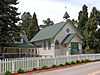
| 24 |
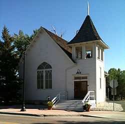
Ruth Memorial Methodist Episcopal Church |
|
01989-05-01-0000May 1, 1989
(#89000332) |
19670 E. Mainstreet
39°31′05″N 104°45′34″W / 39.518056°N 104.759444°W / 39.518056; -104.759444 (Ruth Memorial Methodist Episcopal Church) |
Parker |
|
| 25 |
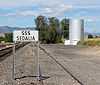
Santa Fe Railway Water Tank |
|
02003-04-18-0000April 18, 2003
(#03000237) |
U.S. Route 85 west of its junction with State Highway 67
39°26′22″N 104°57′50″W / 39.439444°N 104.963889°W / 39.439444; -104.963889 (Santa Fe Railway Water Tank) |
Sedalia |
|
| 26 |
Reginald Sinclaire House |
|
01991-09-20-0000September 20, 1991
(#91001418) |
6154 Perry Park Rd.
39°16′20″N 104°56′39″W / 39.272222°N 104.944167°W / 39.272222; -104.944167 (Reginald Sinclaire House) |
Larkspur |
Home of Reginald Sinclaire, in Colorado Aviation Hall of Fame
|
| 27 |
Spring Valley School |
|
01978-12-18-0000December 18, 1978
(#78000856) |
East of Larkspur at Spring Valley and Lorraine Rds.
39°09′08″N 104°46′10″W / 39.152222°N 104.769444°W / 39.152222; -104.769444 (Spring Valley School) |
Larkspur |
|

.JPG)
.jpg)
.JPG)