| [3] |
Name on the Register[4] |
Image |
Date listed[5] |
Location |
City or town |
Description |
|---|
| 1 |
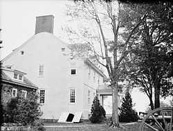
Bethlehem Methodist Episcopal Church |
Upload image |
01979-06-07-0000June 7, 1979
(#79001126) |
Hoopers Neck Rd.
38°28′56″N 76°18′58″W / 38.482222°N 76.316111°W / 38.482222; -76.316111 (Bethlehem Methodist Episcopal Church) |
Taylors Island |
|
| 2 |
Brinsfield I Site |
|
01975-05-12-0000May 12, 1975
(#75000887) |
Address Restricted
|
Cambridge |
|
| 3 |
Cambridge Historic District, Wards I and III |
|
01990-09-05-0000September 5, 1990
(#90001370) |
Roughly bounded by Glasgow, Glenburn, Poplar, Race, and Gay Sts. and the Choptank River
38°34′39″N 76°04′45″W / 38.5775°N 76.079167°W / 38.5775; -76.079167 (Cambridge Historic District, Wards I and III) |
Cambridge |
|
| 4 |
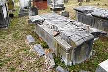
Christ Episcopal Church and Cemetery |
|
01984-04-12-0000April 12, 1984
(#84001767) |
High St.
38°34′19″N 76°04′36″W / 38.571944°N 76.076667°W / 38.571944; -76.076667 (Christ Episcopal Church and Cemetery) |
Cambridge |
|
| 5 |
Dale's Right |
Upload image |
01979-04-03-0000April 3, 1979
(#79001125) |
South of Cambridge on Casson Neck Rd.
38°32′59″N 76°15′05″W / 38.549722°N 76.251389°W / 38.549722; -76.251389 (Dale's Right) |
Cambridge |
|
| 6 |
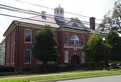
Dorchester County Courthouse and Jail |
|
01982-12-16-0000December 16, 1982
(#82001591) |
206 High St.
38°34′18″N 76°04′34″W / 38.571667°N 76.076111°W / 38.571667; -76.076111 (Dorchester County Courthouse and Jail) |
Cambridge |
|
| 7 |
East New Market Historic District |
|
01975-10-01-0000October 1, 1975
(#75000889) |
Maryland Routes 14 and 16
38°35′53″N 75°55′25″W / 38.598056°N 75.923611°W / 38.598056; -75.923611 (East New Market Historic District) |
East New Market |
|
| 8 |
K. B. Fletcher Mill |
|
01978-12-14-0000December 14, 1978
(#78001456) |
Address Restricted
|
East New Market |
|
| 9 |
Friendship Hall |
|
01973-10-18-0000October 18, 1973
(#73000915) |
Off Maryland Route 14
38°35′41″N 75°55′28″W / 38.594722°N 75.924444°W / 38.594722; -75.924444 (Friendship Hall) |
East New Market |
|
| 10 |
Glasgow |
|
01976-10-08-0000October 8, 1976
(#76000991) |
1500 Hambrooks Boulevard
38°34′58″N 76°05′08″W / 38.582778°N 76.085556°W / 38.582778; -76.085556 (Glasgow) |
Cambridge |
|
| 11 |
Glen Oak Hotel |
|
01983-09-08-0000September 8, 1983
(#83002947) |
201 Academy St.
38°38′07″N 75°51′54″W / 38.635278°N 75.865°W / 38.635278; -75.865 (Glen Oak Hotel) |
Hurlock |
|
| 12 |
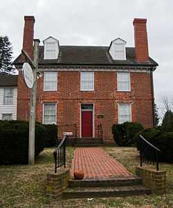
Goldsborough House |
|
01988-12-29-0000December 29, 1988
(#88003062) |
200 High St.
38°34′21″N 76°04′33″W / 38.5725°N 76.075833°W / 38.5725; -76.075833 (Goldsborough House) |
Cambridge |
|
| 13 |
Grace Episcopal Church Complex |
Upload image |
01979-07-24-0000July 24, 1979
(#79001127) |
Hooper Neck Rd.
38°28′15″N 76°18′32″W / 38.470833°N 76.308889°W / 38.470833; -76.308889 (Grace Episcopal Church Complex) |
Taylors Island |
|
| 14 |
Handsell |
|
02008-03-26-0000March 26, 2008
(#08000216) |
4835 Vienna Rhodesdale Rd.
38°30′39″N 75°48′44″W / 38.510833°N 75.812222°W / 38.510833; -75.812222 (Handsell) |
Vienna |
|
| 15 |
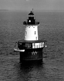
Hooper Island Light Station |
|
02002-12-02-0000December 2, 2002
(#02001426) |
Approximately 5 miles south of Cove Pt
38°15′22″N 76°15′00″W / 38.256111°N 76.25°W / 38.256111; -76.25 (Hooper Island Light Station) |
Hoopersville |
|
| 16 |
LaGrange |
|
01980-01-24-0000January 24, 1980
(#80001809) |
904 LaGrange Ave.
38°33′59″N 76°03′36″W / 38.566389°N 76.06°W / 38.566389; -76.06 (LaGrange) |
Cambridge |
|
| 17 |
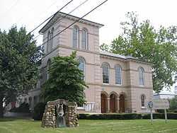
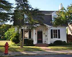
Annie Oakley House |
|
01996-05-07-0000May 7, 1996
(#96000469) |
28 Bellevue Ave.
38°35′22″N 76°05′23″W / 38.589444°N 76.089722°W / 38.589444; -76.089722 (Annie Oakley House) |
Cambridge |
|
| 18 |
PATRICIA (log canoe) |
Upload image |
01985-09-18-0000September 18, 1985
(#85002246) |
903 Roslyn Ave.
38°33′53″N 76°03′41″W / 38.564722°N 76.061389°W / 38.564722; -76.061389 (PATRICIA (log canoe)) |
Cambridge |
|
| 19 |
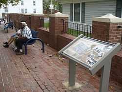
Pine Street Neighborhood Historic District |
|
02012-11-28-0000November 28, 2012
(#12000976) |
High, Pine, & Washington Sts.
38°33′58″N 76°04′56″W / 38.56615°N 76.0822°W / 38.56615; -76.0822 (Pine Street Neighborhood Historic District) |
Cambridge |
|
| 20 |
Rehoboth |
|
01972-11-09-0000November 9, 1972
(#72000577) |
Western side of Punkum Rd.
38°35′14″N 75°47′48″W / 38.587222°N 75.796667°W / 38.587222; -75.796667 (Rehoboth) |
Eldorado |
|
| 21 |
Ridgeton Farm |
Upload image |
01977-10-05-0000October 5, 1977
(#77000694) |
Southwest of Taylor Island on Bay Shore Rd.
38°27′39″N 76°18′24″W / 38.460833°N 76.306667°W / 38.460833; -76.306667 (Ridgeton Farm) |
Taylors Island |
|
| 22 |
Rock Methodist Episcopal Church |
Upload image |
02014-05-28-0000May 28, 2014
(#13000968) |
2403 MD 16
38°32′41″N 76°06′10″W / 38.54481°N 76.102717°W / 38.54481; -76.102717 (Rock Methodist Episcopal Church) |
Cambridge |
|
| 23 |
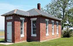
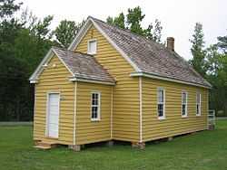
Stanley Institute |
|
01975-09-11-0000September 11, 1975
(#75000888) |
South of Cambridge on Maryland Route 16
38°32′42″N 76°06′27″W / 38.545°N 76.1075°W / 38.545; -76.1075 (Stanley Institute) |
Cambridge |
|
| 24 |
Sycamore Cottage |
|
01988-03-30-0000March 30, 1988
(#88000231) |
417 High St.
38°34′12″N 76°04′46″W / 38.57°N 76.079444°W / 38.57; -76.079444 (Sycamore Cottage) |
Cambridge |
|
| 25 |
Willin Village Archeological Site |
|
01975-05-12-0000May 12, 1975
(#75000890) |
Address Restricted
|
Eldorado |
|
| 26 |
Yarmouth |
Upload image |
01978-03-29-0000March 29, 1978
(#78001455) |
Southeast of Cambridge on Bestpitch Ferry Rd.
38°26′12″N 76°00′10″W / 38.436667°N 76.002778°W / 38.436667; -76.002778 (Yarmouth) |
Cambridge |
|